The test case we are doing in the class is the `Storm of the Century' (or SOC) case that occurred 13-14 March 1993. The date and time of our model simulation will start at 0000 UTC March 13, and the simulation will run for 24 hours till 0000 UTC March 14 1993. You can read more about the case at the end of this chapter.
Create a working directory, such as `tutorial' or `MM5V3'. cd to it, and obtain MM5 program tar files under the directory from NCAR's anonymous ftp site:
> Password: your-email-address
`prompt' and `mget' allow you to download all files with .gz. Uncompress each program tar file:
Before you start to work on the first program, TERRAIN, in the MM5 modeling system, check to see if you have NCAR Graphics installed on your machine, since program TERRAIN can make a good use of the NCAR Graphics when one configures the model domains. Refer to Chapter 2, section 2.3 to see if NCARG_ROOT is set. If your NCAR Graphics is installed in a different directory than those listed, you may need to edit Makefiles in TERRAIN, RAWINS and GRAPH to change how NCAR Graphics library is loaded (look for LOCAL_LIBRARIES for your particular platform).
Once you have done this, you are ready to start with program TERRAIN.
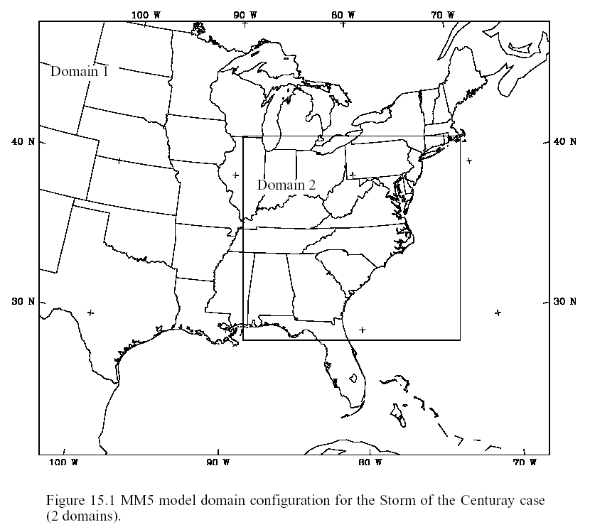
Figure 15.1 shows the model domain set up for the SOC case. The domain configurations for the case study are summarize below.
Centered at 36.0 N and 85.0 W (remember west longitude is negative). The grid size is 90 km, and the domain IX (north-south) and JX (east-west) dimensions are 35x41. Use expanded coarse domain for objective analysis. The expansion on each side of coarse domain is 360 km.
Resides inside the coarse domain. Domain 2 dimensions are 49x52, and the grid spacing is 30 km. The location of (1,1) point of the fine mesh in the coarse mesh is 10 and 17, respectively.
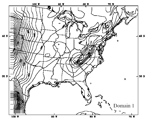
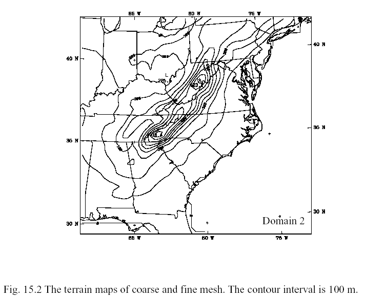
Run TERRAIN program on two domains according to Fig. 15.1 to obtain the terrain and land-use data for REGRID. Use either old 13 category landuse, or new landuse. Figure 15.2 shows the maps of terrain for the two domains. Either use the old or new landuse data. For this exercise we will not use the land-surface model option.
Use the NCEP ON84 first guess field and NCEP ON84 SST for REGRID. Obtain the first guess fields only on coarse domain at 10 mandatory pressure levels (default) and a few new levels. The mandatory pressure levels are 100000, 85000, 70000, 50000, 40000, 30000, 25000, 20000, 15000, and 10000 Pascals, and new levels are 95000, 92500, 90000, 80000, 75000, 65000, 60000, 55000, 45000, 35000 Pascals. Define ptop_in_Pa = 10000 Pascals. Obtain first guess for 3 time periods: 1993-03-13_00, 1993-03-13_12, and 1993-03-14_00. Use snow cover option. (Note, if you choose to run little_r later, you must create all new levels (see below) in REGRID.)
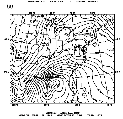
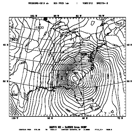
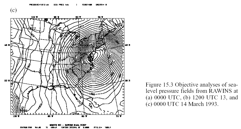
Run little_r (or Rawins) only for coarse domain. Create surface FDDA file for coarse domain. Analyzed sea-level pressure fields are shown in Fig. 15.3.
Define the full σ levels in namelist.input file as 1., .99, .98, .96, .93, .89, .85, .8, .75, .7, .65, .6, .55, .5, .45, .4, .35, .3, .25, .2, .15,.1, 0.05, and 0.0. Use INTERPF to obtain the initial, lateral and lower boundary condition files for domain 1 to run MM5 for the 3 time periods. Set isfc=1, usesfc=.TRUE., and reference state parameters p0, tlp and ts0.
Run the model on the desktop workstation, starting by obtaining the mm5 tar file.
Start the MM5 model at 0000 UTC 13 March, 1993, and integrate for 24 hours. Use the boundary and initial condition files from Interpf for domain 1, and domain 2 terrain input file from Terrain program output as input. Output history files every 6 hours. Save files for restart and set SVLAST = .TRUE.. Set time step to be 270 sec. Use IOVERW=2 for the nest.
Use the following physics in the MM5 simulation. Remember some switches are set in configure.user file, and some in mm5.deck.
1) Run 1 (This run requires about 40 Mb memory, and 2100 sec. if you are the only running):
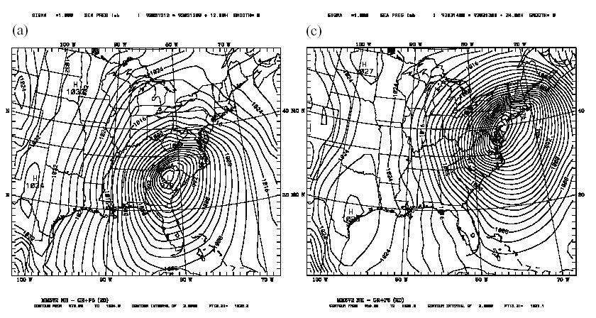
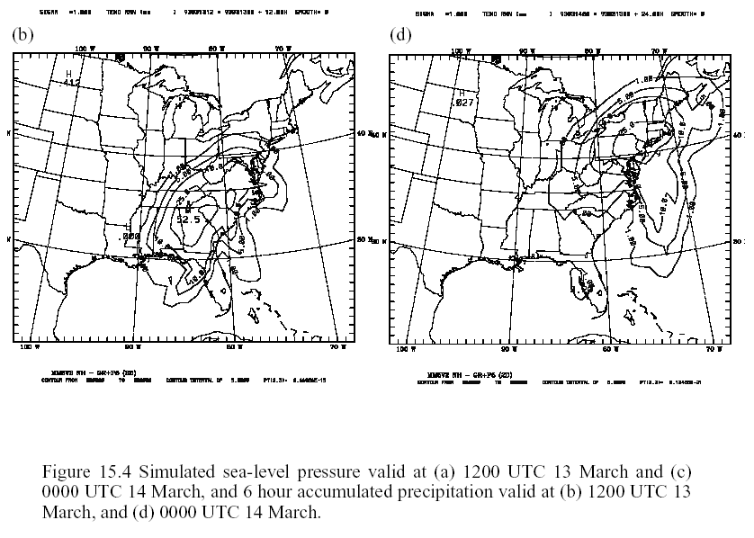
MM5 simulated sea-level pressure and precipitation are shown in Fig. 15.4.
Use RIP or Graph program to view the model output you generate. For RIP, follow the instruction given in Appendix G. For Graph, follow the instruction given in Chapter 12. Run RIP/Graph for both domain 1 and 2 model outputs.
The following is a reprint of an article from the Web page:
NATIONAL CLIMATIC DATA CENTER RESEARCH CUSTOMER SERVICE GROUP
A REVIEW OF THE MARCH 12-14, 1993 "STORM OF THE CENTURY"
NEAL LOTT, PHYSICAL SCIENTIST, MAY 14, 1993
******************************************************************************
On March 12-15, a storm now called "The Storm of the Century" struck the eastern seaboard. Following are the highlights of the information gathered about the storm thus far:
1) The preliminary death toll for the U.S. is approximately 270, and 48 people were reported as missing at sea (Gulf of Mexico and Atlantic, including Canadian waters). This is over 3 times the combined death toll of 79 attributed to hurricanes Hugo and Andrew. The death toll includes those caused by direct and indirect (e.g., shoveling snow) results of the storm. Due to the widespread nature of the storm, assessing its toll has been quite difficult for damage survey teams--hurricanes are easier to assess due to their more limited areal coverage. The following breakdown by state (not including lost at sea) is still preliminary (its summation does not reflect all deaths from the storm):
Florida 44; New York 23; South Carolina 1; Alabama 16; Georgia 15;
Tennessee 14, North Carolina 19; Kentucky 5; Virginia 13; Maryland 3;
West Virginia 4; Maine 2; Pennsylvania 49
2) Thousands of people were isolated by record snowfalls, especially in the Georgia, North Carolina, and Virginia mountains. Over 200 hikers were rescued from the North Carolina and Tennessee mountains. Curfews were enforced in many counties and cities as `states of emergency' were declared. The National Guard was deployed in many areas to protect lives and property. Generally, all interstate highways from Atlanta northward were closed.
3) For the first time, every major airport on the east coast was closed at one time or another by the storm. The Asheville, NC airport was closed for 3 days. Snowfall rates of 2-3 inches per hour were common during the height of the storm. Generally, New York's Catskill Mountains along with most of the central and southern Appalachians received at least 2 feet of snow. In areas to the east, wind-driven sleet occurred in some areas, with central New Jersey reporting 2.5 inches of sleet on top of 12 inches of snow--somewhat of an "ice-cream sandwich" affect.
4) Hundreds of roof collapses occurred due to the weight of the heavy wet snow. Over 3 million customers were without electrical power at one time due to fallen trees and high winds.
5) At least 18 homes fell into the sea on Long Island due to the pounding surf. About 200 homes along North Carolina's Outer Banks were damaged and may be uninhabitable. Over 160 people were rescued at sea by the Coast Guard in the Gulf of Mexico and Atlantic. At least 1 freighter sank in the Gulf of Mexico.
6) Florida was struck by an estimated 15 tornadoes, and 44 deaths in Florida were attributed either to the tornadoes or other severe weather. A 12-foot storm surge occurred in Taylor County, FL resulting in at least 7 deaths. Also, up to 6 inches of snow fell in the Florida panhandle.
7) 3 storm-related deaths were reported in Quebec and 1 in Ontario. About 110 miles south of Cape Sable Island, Nova Scotia, a 177-meter ship sank in heavy seas, with all 33 of its crew lost at sea. 65-foot waves were reported in the area. Also, a wind gust of 131 MPH occurred at Grand Etang, Nova Scotia. Some parts of northern New Brunswick experienced temperature drops of 45 degrees Fahrenheit in 18 hours. 3 deaths occurred in Cuba (Havana was blacked out), and a tornado left 5000 people homeless in Reynosa, Mexico (near Texas border).
8) Highest recorded wind gusts included:
144 MPH on Mount Washington, NH
109 MPH in the Dry Tortugas (west of Key West, FL)
101 MPH on Flattop Mountain, NC (by NCDC employee Grant Goodge--due to ice accumulation on anemometer, he estimated 105- 107 MPH)
92 MPH on South Marsh Island, LA
56 inches on Mount LeConte, TN
50 inches on Mount Mitchell, NC (14-foot drifts)
36 inches in Latrobe, PA (10-foot drifts)
24 inches in Mountain City, GA
19 inches in Portland, ME 19 inches in Asheville, NC
17 inches near Birmingham, AL (6-foot drifts) 16 inches in Roanoke, VA
10) Record low temperatures included (some records for March):
-12 degrees in Burlington, VT and Caribou, ME
-10 degrees on Mount LeConte, TN
-4 degrees in Waynesville, NC and Rochester, NY
2 degrees in Asheville, NC and Birmingham, AL
11 degrees in Chattanooga, TN and Philadelphia, PA
15 degrees in New York-JFK and Washington, DC
18 degrees in Columbia, SC and Atlanta, GA
19 degrees in Augusta, GA 21 degrees in Mobile, AL
25 degrees in Savannah, GA and Pensacola, FL
31 degrees in Daytona Beach, FL
11) Record low sea-level pressures included:
28.38 inches in White Plains, NY
28.43 inches in Philadelphia, PA
28.54 inches in Washington, DC
28.61 inches in Raleigh-Durham, NC
28.74 inches in Greenville-Spartanburg, SC
12) The National Weather Service's Office of Hydrology estimated the volume of water that fell as snow as 44 million acre-feet. This is comparable to 40 days' flow on the Mississippi River at New Orleans. For example, the NWS office at the Asheville, NC airport reported a snow/water ratio of 4.2 to 1 from core samples of new snow. Numerous core samples taken in a nearby area by an NCDC employee showed similar results with a ratio of 5.3 to 1. This equated to 4-5 inches of liquid equivalent precipitation (or even higher in some areas) from the storm. Areas north of Asheville which reported up to 4 feet of snow probably received `dryer' snow with similar liquid equivalent amounts. Due to the weight of the heavy snow, damage to trees and some buildings was extensive. Polk County, NC reported 99% of its electrical customers without power at one point during the storm. Some sleet also occurred during the storm, contributing to its `heavy' nature. Many of the power outages occurred before the high winds arrived (due to snow-induced tree damage).
13) Overall damage figures are not yet complete, but the insured property damage estimates now exceed $1.6 billion. Therefore, this was the 4th costliest storm in U.S. history, and by far the most costly extra-tropical storm. Some estimates of total damages and costs from the storm now exceed $6 billion.