The Version 1 header has been in use since 1994. During the period since, several ways to improve on it became apparent, and these are put into effect with Version 3. Firstly, Version 1 files are unnecessarily long because before every time period there are about 3.5 Mbytes of header record, only a small fraction of which is used. Version 1 had a first effort at a format that was self-describing, in that the header contains information about all the fields in the file. However it was made a little awkward to use because this information on each field is buried in the header. When adding a new field, the location and order in the header had to be consistent, as well as updating the total number of fields, so the files were difficult to manipulate.
Version 3 improves in both respects: the files are shorter, and it becomes easier to add or retrieve selected fields. The length of the header is reduced. The header still has 20 sections (second index which indicates program name), but now only 50 integers, and 20 reals, together with their 80-character descriptions, are in each section. This makes the header size a little over 100 kbytes. Moreover, there is only one header which is at the beginning of the file, but there is enough generality in the format to allow more headers at other times such as at the beginning of a restart run or when a nest moves. The header still contains information about the preprocessor options, and domain characteristics and location. However it no longer contains 1-dimensional fields, such as sigma or pressure levels, nor information about what is in the rest of the file. Version 3 introduces the concept of a sub-header, a 1-record description directly ahead of each field. This description includes information on the name, dimensionality, index order, index range, size and time of the following field. Flags in the file indicate whether to read a "big header'', or sub-header and field, or whether it is the end of a time period. It can be seen that it is easy to insert a field as long as it is accompanied by a relevant flag and sub-header. It is also easy to search for a given field by reading sub-headers until a match is found then reading the following field.
An MM5 Version 3 modeling system output file contains the following records:
big header flag (integer value of 0)
sub-header flag (integer value of 1)
sub-header flag (integer value of 1)
sub-header flag (integer value of 1)
end-of-time-period flag (integer value of 2)
sub-header flag (integer value of 1)
sub-header flag (integer value of 1)
sub-header flag (integer value of 1)
end-of-time-period flag (integer value of 2)
No particular order of fields is assumed, other than that they are chronologically grouped. When reading files in the modeling system, each field has to be read and matched to an expected 8-character name before being assigned to a variable in the program. Note that 1D, 2D, and 3D fields could be mixed, but that the sub-header gives enough information to assign an appropriate array to the read statement.
Thus, a simple read program would look like:
read (input_unit, end=900) flag
In Version 3, there are two boundary condition files: one contains only the lateral boundary condition arrays, and the other the lower boundary condition file which fields like substrate temperature and SST. Both files have the same file structure as the rest of modeling system output files.
The big header has four 2-D arrays similar to that in the V1/V2 system, which we refer to in the V3 modeling system programs as
and the dimensions of these arrays are
BHI(50,20),BHR(20,20),BHIC(50,20),BHRC(20,20)
where BHI is an integer array, and BHIC is the companion array that contains the description of what is in BHI. Similarly BHR is a real array, and BHRC contains the description of what is in BHR.
The first value in the header, BHI(1,1), still represents data types. But there are some changes as shown below:
BHI(1,1) |
Data Types |
|
1 |
Terrain |
|
2 |
Regrid |
|
3 |
Little_R / Rawins |
|
4 |
Rawins' surface analysis |
|
5 |
Model initial condition file |
|
6 |
Model lower boundary condition file |
|
7 |
Model lateral boundary condition file |
|
8 |
Interpolated model output on pressure levels |
|
11 |
Model output |
MM5 model output actually occupies header locations 11 through 16.
A sub-header contains the following information:
ndim, start_index(4), end_index(4), xtime, staggering, ordering, current_date, name, units, description
ndim: |
integer |
dimension of the field (integer) |
start_index: |
integer(4) |
starting indices of the field array (generally 1's) |
end_index: |
integer(4) |
ending indices of the field array (generally IX, JX, KX, and 1) (the fourth dimension is not yet used) |
xtime: |
real |
the integration or forecast time for this field (unit in minutes) |
staggering: |
char*4 |
whether the field is at dot or cross point (character C or D) |
ordering: |
char*4 |
the order of the field array dimension (4-character string with the following values: YXP: 3-D field, pressure data dimensioned by (IX,JX,KXP) YXS: 3-D field, sigma data dimensioned by (IX,JX,KXS) YXW: 3-D field, sigma data dimensioned by (IX,JX,KXS+1) (e.g. vertical motion in MM5) YX: 2-D field, with array dimensioned by (IX,JX) with IX in Y direction. CA: 2-D field, with array dimensioned by (landuse-categories,2). Arrays storing land property values, such as albedo, roughness length, etc. XSB: 3-D field, containing north and south boundary arrays, dimensioned by (JX,KXS,5) YSB: 3-D field, containing west and east boundary arrays, dimensioned by (IX,KXS,5) XWB: 3-D field, containing north and south boundary arrays for vertical motion, dimensioned by (JX,KXS+1,5) YWB: 3-D field, containing west and east boundary arrays forvertical motion, dimensioned by (IX,KXS+1,5) P: 1-D field, pressure level array S: 1-D field, sigma level array |
current_date: |
char*24 |
24-character representation of date valid for this field |
name: |
char*8 |
8-character field name (kept the same as in Version 1/2 system) |
unit: |
char*25 |
25-character unit description |
description: |
char*46 |
field description (kept mostly the same as in Version 1/2 system) |
There are few locations in big header that contains special information about the data (where X is the number indicating the program name:
BHI(1,1): Program name for this dataset
BHI(2,X): Version 3 MM5 system format edition number
BHI(3,X): Program version number
BHI(4,X): Program minor revision number
BHI(5-10,X): Beginning time for this dataset
BHI(12,X): Number of vertical levels in this dataset
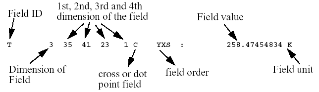
In the following pages, you will see a complete list of big record header in each MM5 dataset, and a list of output fields from the dataset. What printed in the output field list are the following: field name, dimension of the field (either 1, 2 or 3), first (y), second (x), and third (pressure or s) dimension of the field, forth dimension of the field (1; and not used), whether the field is a cross (C) or dot (D) one, how the field is ordered (YXS, for example), a value from the field (in the middle of the domain), and the unit for the field. For example,
TERRAIN Portion of big header:
BHI( 1, 1): 1 : PROGRAM NAME : TERRAIN
BHI( 2, 1): 1 : TERRAIN VERSION 3 MM5 SYSTEM FORMAT EDITION NUMBER
BHI( 3, 1): 6 : TERRAIN PROGRAM VERSION NUMBER
BHI( 4, 1): 1 : TERRAIN PROGRAM MINOR REVISION NUMBER
BHI( 5, 1): 35 : COARSE DOMAIN GRID DIMENSION IN I (N-S) DIRECTION
BHI( 6, 1): 41 : COARSE DOMAIN GRID DIMENSION IN J (E-W) DIRECTION
BHI( 7, 1): 1 : MAP PROJECTION. 1: LAMBERT CONFORMAL, 2: POLAR STEREOGRAPHIC,
3:
MERCATOR
BHI( 8, 1): 0 : IS COARSE DOMAIN EXPANDED?, 1: YES, 0: NO
BHI( 9, 1): 35 : EXPANDED COARSE DOMAIN GRID DIMENSION IN I DIRECTION
BHI( 10, 1): 41 : EXPANDED COARSE DOMAIN GRID DIMENSION IN J DIRECTION
BHI( 11, 1): 0 : GRID OFFSET IN I DIR DUE TO COARSE GRID EXPANSION
BHI( 12, 1): 0 : GRID OFFSET IN J DIR DUE TO COARSE GRID EXPANSION
BHI( 13, 1): 1 : DOMAIN ID
BHI( 14, 1): 1 : MOTHER DOMAIN ID
BHI( 15, 1): 0 : NEST LEVEL (0: COARSE MESH)
BHI( 16, 1): 35 : DOMAIN GRID DIMENSION IN I DIRECTION
BHI( 17, 1): 41 : DOMAIN GRID DIMENSION IN J DIRECTION
BHI( 18, 1): 1 : I LOCATION IN THE MOTHER DOMAIN OF THE DOMAIN POINT (1,1)
BHI( 19, 1): 1 : J LOCATION IN THE MOTHER DOMAIN OF THE DOMAIN POINT (1,1)
BHI( 20, 1): 1 : DOMAIN GRID SIZE RATIO WITH RESPECT TO COARSE DOMAIN
BHI( 21, 1): 1 : DOMAIN GRID SIZE RATIO WITH RESPECT TO MOTHER DOMAIN
BHI( 22, 1): 2 : SMOOTHER (1: 1-2-1, 2:SMOOTHER-DESMOOTHER)
BHI( 23, 1): 16 : USGS 25-CATEGORY LAND USE: WATER CATEGORY
BHI( 24, 1): 1 : IS THIS DOMAIN A ONE-WAY OR TWO-WAY NEST? 1: 1-WAY,
2:
2-WAY. 1 FOR DOMAIN 1
***Floats:
BHR( 1, 1): 90000.00 : COARSE DOMAIN GRID DISTANCE (m)
BHR( 2, 1): 36.00 : COARSE DOMAIN CENTER LATITUDE (degree)
BHR( 3, 1): -85.00 : COARSE DOMAIN CENTER LONGITUDE (degree)
BHR( 4, 1): 0.72 : CONE FACTOR
BHR( 5, 1): 60.00 : TRUE LATITUDE 1 (degree)
BHR( 6, 1): 30.00 : TRUE LATITUDE 2 (degree)
BHR( 7, 1): 90.00 : POLE POSITION IN DEGREE LATITUDE
BHR( 8, 1):360000.00 : APPROX EXPANSION (m)
BHR( 9, 1): 90000.00 : GRID DISTANCE (m) OF THIS DOMAIN
BHR( 10, 1): 1.00 : I LOCATION IN THE COARSE DOMAIN OF THE DOMAIN POINT (1,1)
BHR( 11, 1): 1.00 : J LOCATION IN THE COARSE DOMAIN OF THE DOMAIN POINT (1,1)
BHR( 12, 1): 35.00 : I LOCATION IN THE COARSE DOMAIN OF THE DOMAIN POINT (IX,JX)
BHR( 13, 1): 41.00 : J LOCATION IN THE COARSE DOMAIN OF THE DOMAIN POINT (IX,JX)
BHR( 14, 1): 0.50 : TERRAIN DATA RESOLUTION (in degree)
BHR( 15, 1): 0.50 : LANDUSE DATA RESOLUTION (in degree)
0000-00-00_00:00:00 0.00000 Hours
TERRAIN 2 35 41 1 1 C YX : 475.45861816 m
LAND USE 2 35 41 1 1 C YX : 11.00000000 category
VEGFRC01 2 35 41 1 1 C YX : 39.89308548 %
VEGFRC02 2 35 41 1 1 C YX : 43.45289612 %
VEGFRC03 2 35 41 1 1 C YX : 50.00000000 %
VEGFRC04 2 35 41 1 1 C YX : 68.57250977 %
VEGFRC05 2 35 41 1 1 C YX : 100.00000000 %
VEGFRC06 2 35 41 1 1 C YX : 98.89189148 %
VEGFRC07 2 35 41 1 1 C YX : 99.99304199 %
VEGFRC08 2 35 41 1 1 C YX : 94.87342834 %
VEGFRC09 2 35 41 1 1 C YX : 94.89308167 %
VEGFRC10 2 35 41 1 1 C YX : 77.98728943 %
VEGFRC11 2 35 41 1 1 C YX : 48.47255707 %
VEGFRC12 2 35 41 1 1 C YX : 40.46560287 %
TEMPGRD 2 35 41 1 1 C YX : 285.15682983 K
LANDMASK 2 35 41 1 1 C YX : 1.00000000 category
SOILINDX 2 35 41 1 1 C YX : 6.00000000 category
LATITCRS 2 35 41 1 1 C YX : 35.58544922 degree
LONGICRS 2 35 41 1 1 C YX : -85.50784302 degree
MAPFACCR 2 35 41 1 1 C YX : 0.98003817 dimensionless
LATITDOT 2 35 41 1 1 D YX : 35.16879654 degree
LONGIDOT 2 35 41 1 1 D YX : -86.00925446 degree
MAPFACDT 2 35 41 1 1 D YX : 0.98123306 dimensionless
CORIOLIS 2 35 41 1 1 D YX : 0.00008400 1/s
REGRID Portion of big header:
***Integers:
BHI( 2, 2): 1 : REGRID Version 3 MM5 System Format Edition
Number
BHI( 3, 2): 6 : REGRID Program Version Number
BHI( 4, 2): 1 : REGRID Program Minor Revision Number
BHI( 5, 2): 1993 : Four digit year of the start time
BHI( 6, 2): 3 : Two digit month (01 through 12) of the start time
BHI( 7, 2): 13 : Two digit day (01 through 31) of the start time
BHI( 8, 2): 0 : Two digit hour (00 through 23) of the start time
BHI( 9, 2): 0 : Two digit minute (00 through 59) of the start time
BHI( 10, 2): 0 : Two digit second (00 through 59) of the start time
BHI( 11, 2): 0 : Four digit ten thousandth of a second (0000 through 9999)
of the start time
BHI( 12, 2): 21 : Anticipated number of vertical levels in 3d data
***Floats:
BHR( 1, 2): 43200.00 : Time increment between analysis times (s)
BHR( 2, 2): 10000.00 : Top pressure used in analysis, pressure defining model lid (Pa)
1993-03-13_00:00:00.0000 0.00000 Hours
T 3 35 41 21 1 C YXP : 262.65667725 K
U 3 35 41 21 1 D YXP : 7.14344168 m/s
V 3 35 41 21 1 D YXP : 10.38981056 m/s
RH 3 35 41 21 1 C YXP : 96.45741272 %
H 3 35 41 21 1 C YXP : 3529.16406250 m
ALBSNOMX 2 35 41 1 1 C YX : 38.97982025 %
PSEALVLC 2 35 41 1 1 C YX : 101799.22656250 Pa
SKINTEMP 2 35 41 1 1 C YX : 276.31039429 K
WEASD 2 35 41 1 1 C YX : 0.00000000 kg m{-2}
SOILT010 2 35 41 1 1 C YX : 277.13571167 K
SOILT200 2 35 41 1 1 C YX : 280.43368530 K
SOILT400 2 35 41 1 1 C YX : 286.95452881 K
SOILM010 2 35 41 1 1 C YX : 0.33993921 fraction
SOILM200 2 35 41 1 1 C YX : 0.37924942 fraction
SEAICE 2 35 41 1 1 C YX : 0.00000000 0/1 Flag
SNOWCOVR 2 35 41 1 1 C YX : 0.00000000 0/1 Flag
PSEALVLD 2 35 41 1 1 D YX : 101726.61718750 Pa
TERRAIN 2 35 41 1 1 C YX : 475.45861816 m
LAND USE 2 35 41 1 1 C YX : 11.00000000 category
VEGFRC01 2 35 41 1 1 C YX : 39.89308548 %
VEGFRC02 2 35 41 1 1 C YX : 43.45289612 %
VEGFRC03 2 35 41 1 1 C YX : 50.00000000 %
VEGFRC04 2 35 41 1 1 C YX : 68.57250977 %
VEGFRC05 2 35 41 1 1 C YX : 100.00000000 %
VEGFRC06 2 35 41 1 1 C YX : 98.89189148 %
VEGFRC07 2 35 41 1 1 C YX : 99.99304199 %
VEGFRC08 2 35 41 1 1 C YX : 94.87342834 %
VEGFRC09 2 35 41 1 1 C YX : 94.89308167 %
VEGFRC10 2 35 41 1 1 C YX : 77.98728943 %
VEGFRC11 2 35 41 1 1 C YX : 48.47255707 %
VEGFRC12 2 35 41 1 1 C YX : 40.46560287 %
TEMPGRD 2 35 41 1 1 C YX : 285.15682983 K
LANDMASK 2 35 41 1 1 C YX : 1.00000000 category
SOILINDX 2 35 41 1 1 C YX : 6.00000000 category
LATITCRS 2 35 41 1 1 C YX : 35.58544922 degree
LONGICRS 2 35 41 1 1 C YX : -85.50784302 degree
MAPFACCR 2 35 41 1 1 C YX : 0.98003817 dimensionless
LATITDOT 2 35 41 1 1 D YX : 35.16879654 degree
LONGIDOT 2 35 41 1 1 D YX : -86.00925446 degree
MAPFACDT 2 35 41 1 1 D YX : 0.98123306 dimensionless
CORIOLIS 2 35 41 1 1 D YX : 0.00008400 1/s
BHI( 2, 3): 1 : little_r Version 3 MM5 System Format Edition Number
BHI( 3, 3): 6 : little_r Program Version Number
BHI( 4, 3): 1 : little_r Program Minor Revision Number
BHI( 5, 3): 1993 : FOUR-DIGIT YEAR OF THE STAR TIME (1900 - 2099)
BHI( 6, 3): 3 : TWO-DIGIT MONTH OF THE START TIME (01-12)
BHI( 7, 3): 13 : TWO-DIGIT DAY OF THE START TIME (01-31)
BHI( 8, 3): 0 : TWO-DIGIT HOUR OF THE START TIME (00-23)
BHI( 9, 3): 0 : TWO-DIGIT MINUTE OF THE START TIME (00-59)
BHI( 10, 3): 0 : TWO-DIGIT SECOND OF THE START TIME (00-59)
BHI( 11, 3): 0 : FOUR-DIGIT TEN-THOUSANDTH OF A SECOND OF THE START TIME (
BHI( 12, 3): 21 : NUMBER OF PRESSURE LEVELS IN OUTPUT, INCLUDING SURFACE LEVEL
BHR( 1, 3): 43200.00 : TIME DIFFERENCE (s) BETWEEN OUTPUT ANALYSIS TIMES
BHR( 2, 3): 10.00 : MAXIMUM TEMPERATURE DIFFERENCE ALLOWED IN ERROR MAX (K)
BHR( 3, 3): 13.00 : MAXIMUM SPEED DIFFERENCE ALLOWED IN ERROR MAX (m/s)
BHR( 4, 3): 6.00 : MAXIMUM SEA-LEVEL PRESSURE DIFFERENCE ALLOWED IN ERROR MAX (Pa)
BHR( 5, 3): 1.00 : TOLERANCE FOR BUDDY CHECK (0 = NO BUDDY CHECK)
1993-03-13_00:00:00.0000 0.00000 Hours
T 3 35 41 21 1 C YXP : 263.60055542 K
U 3 35 41 21 1 D YXP : 7.07863760 m/s
V 3 35 41 21 1 D YXP : 9.47566032 m/s
RH 3 35 41 21 1 C YXP : 100.00000000 %
H 3 35 41 21 1 C YXP : 3529.16406250 m
ALBSNOMX 2 35 41 1 1 C YX : 38.97982025 %
PSEALVLC 2 35 41 1 1 C YX : 101740.06250000 Pa
SKINTEMP 2 35 41 1 1 C YX : 276.31039429 K
WEASD 2 35 41 1 1 C YX : 0.00000000 kg m{-2}
SOILT010 2 35 41 1 1 C YX : 277.13571167 K
SOILT200 2 35 41 1 1 C YX : 280.43368530 K
SOILT400 2 35 41 1 1 C YX : 286.95452881 K
SOILM010 2 35 41 1 1 C YX : 0.33993921 fraction
SOILM200 2 35 41 1 1 C YX : 0.37924942 fraction
SEAICE 2 35 41 1 1 C YX : 0.00000000 0/1 Flag
SNOWCOVR 2 35 41 1 1 C YX : 0.00000000 0/1 Flag
PSEALVLD 2 35 41 1 1 D YX : 101726.61718750 Pa
TERRAIN 2 35 41 1 1 C YX : 475.45861816 m
LAND USE 2 35 41 1 1 C YX : 11.00000000 category
VEGFRC01 2 35 41 1 1 C YX : 39.89308548 %
VEGFRC02 2 35 41 1 1 C YX : 43.45289612 %
VEGFRC03 2 35 41 1 1 C YX : 50.00000000 %
VEGFRC04 2 35 41 1 1 C YX : 68.57250977 %
VEGFRC05 2 35 41 1 1 C YX : 100.00000000 %
VEGFRC06 2 35 41 1 1 C YX : 98.89189148 %
VEGFRC07 2 35 41 1 1 C YX : 99.99304199 %
VEGFRC08 2 35 41 1 1 C YX : 94.87342834 %
VEGFRC09 2 35 41 1 1 C YX : 94.89308167 %
VEGFRC10 2 35 41 1 1 C YX : 77.98728943 %
VEGFRC11 2 35 41 1 1 C YX : 48.47255707 %
VEGFRC12 2 35 41 1 1 C YX : 40.46560287 %
TEMPGRD 2 35 41 1 1 C YX : 285.15682983 K
LANDMASK 2 35 41 1 1 C YX : 1.00000000 category
SOILINDX 2 35 41 1 1 C YX : 6.00000000 category
LATITCRS 2 35 41 1 1 C YX : 35.58544922 degree
LONGICRS 2 35 41 1 1 C YX : -85.50784302 degree
MAPFACCR 2 35 41 1 1 C YX : 0.98003817 dimensionless
LATITDOT 2 35 41 1 1 D YX : 35.16879654 degree
LONGIDOT 2 35 41 1 1 D YX : -86.00925446 degree
MAPFACDT 2 35 41 1 1 D YX : 0.98123306 dimensionless
CORIOLIS 2 35 41 1 1 D YX : 0.00008400 1/s
SFC RAWINS Portion of big header:
BHI( 2, 4): 1 : little_r Version 3 MM5 System Format Edition Number
BHI( 3, 4): 6 : little_r Program Version Number
BHI( 4, 4): 1 : little_r Program Minor Revision Number
BHI( 5, 4): 1993 : FOUR-DIGIT YEAR OF THE STAR TIME (1900 - 2099)
BHI( 6, 4): 3 : TWO-DIGIT MONTH OF THE START TIME (01-12)
BHI( 7, 4): 13 : TWO-DIGIT DAY OF THE START TIME (01-31)
BHI( 8, 4): 0 : TWO-DIGIT HOUR OF THE START TIME (00-23)
BHI( 9, 4): 0 : TWO-DIGIT MINUTE OF THE START TIME (00-59)
BHI( 10, 4): 0 : TWO-DIGIT SECOND OF THE START TIME (00-59)
BHI( 11, 4): 0 : FOUR-DIGIT TEN-THOUSANDTH OF A SECOND OF THE START TIME (
BHI( 12, 4): 1 : NUMBER OF PRESSURE LEVELS IN OUTPUT, INCLUDING SURFACE LEVEL
BHR( 1, 4): 10800.00 : TIME DIFFERENCE (seconds) BETWEEN SURFACE ANALYSES
1993-03-13_00:00:00.0000 0.00000 Hours
T 2 35 41 1 1 C YX : 273.91900635 K
U 2 35 41 1 1 D YX : -0.72313094 m/s
V 2 35 41 1 1 D YX : -4.36657429 m/s
RH 2 35 41 1 1 C YX : 91.08442688 %
Q 2 35 41 1 1 C YX : 0.00384220 kg kg{-1}
PSTARCRS 2 35 41 1 1 C YX : 85925.07812500 Pa
PSEALVLC 2 35 41 1 1 C YX : 101738.28125000 Pa
BHI( 2, 5): 1 : INTERP Version 3 MM5 System Format Edition Number
BHI( 3, 5): 6 : INTERP Program Version Number
BHI( 4, 5): 1 : INTERP Program Minor Revision Number
BHI( 5, 5): 1993 : Four-digit year of start time
BHI( 6, 5): 3 : Month of the year of the start time (1-12)
BHI( 7, 5): 13 : Day of the month of the start time (1-31)
BHI( 8, 5): 0 : Hour of the day of the start time (0-23)
BHI( 9, 5): 0 : Minute of the start time (0-59)
BHI( 10, 5): 0 : Second of the start time (0-59)
BHI( 11, 5): 0 : Ten thousandths of a second of the start time (0-9999)
BHI( 12, 5): 23 : Number of half-sigma layers in the model input data (top down)
BHR( 1, 5): 43200.00 : Time difference (seconds) between model IC input files
BHR( 2, 5):100000.00 : Non-hydrostatic base state sea-level pressure (Pa)
BHR( 3, 5): 275.00 : Non-hydrostatic base state sea-level temperature (K)
BHR( 4, 5): 50.00 : Non-hydrostatic base state lapse rate d(T)/d(ln P)
BHR( 5, 5): 0.00 : Non-hydrostatic base state isothermal stratospheric
1993-03-13_00:00:00.0000 0.00000 Hours
T 3 35 41 23 1 C YXS : 259.52917480 K
U 3 35 41 23 1 D YXS : 13.80757618 m/s
V 3 35 41 23 1 D YXS : 14.90762901 m/s
Q 3 35 41 23 1 C YXS : 0.00224648 kg/kg
PP 3 35 41 23 1 C YXS : 1911.64038086 Pa
W 3 35 41 24 1 C YXW : 0.04734292 m/s
GROUND T 2 35 41 1 1 C YX : 273.84320068 K
PSTARCRS 2 35 41 1 1 C YX : 84232.07031250 Pa
TSFC 2 35 41 1 1 C YX : 273.84320068 K
USFC 2 35 41 1 1 D YX : -0.79890132 m/s
VSFC 2 35 41 1 1 D YX : -4.37785530 m/s
RHSFC 2 35 41 1 1 C YX : 85.66202545 %
HSFC 2 35 41 1 1 C YX : 475.45861816 m
ALBSNOMX 2 35 41 1 1 C YX : 38.97982025 %
PSEALVLC 2 35 41 1 1 C YX : 101740.06250000 Pa
TSEASFC 2 35 41 1 1 C YX : 276.31039429 K
WEASD 2 35 41 1 1 C YX : 0.00000000 kg m{-2}
SOILT010 2 35 41 1 1 C YX : 277.13571167 K
SOILT200 2 35 41 1 1 C YX : 280.43368530 K
SOILT400 2 35 41 1 1 C YX : 286.95452881 K
SOILM010 2 35 41 1 1 C YX : 0.33993921 fraction
SOILM200 2 35 41 1 1 C YX : 0.37924942 fraction
SEAICE 2 35 41 1 1 C YX : 0.00000000 0/1 Flag
SNOWCOVR 2 35 41 1 1 C YX : 0.00000000 0/1 Flag
PSEALVLD 2 35 41 1 1 D YX : 101726.61718750 Pa
TERRAIN 2 35 41 1 1 C YX : 475.45861816 m
LAND USE 2 35 41 1 1 C YX : 11.00000000 category
VEGFRC01 2 35 41 1 1 C YX : 39.89308548 %
VEGFRC02 2 35 41 1 1 C YX : 43.45289612 %
VEGFRC03 2 35 41 1 1 C YX : 50.00000000 %
VEGFRC04 2 35 41 1 1 C YX : 68.57250977 %
VEGFRC05 2 35 41 1 1 C YX : 100.00000000 %
VEGFRC06 2 35 41 1 1 C YX : 98.89189148 %
VEGFRC07 2 35 41 1 1 C YX : 99.99304199 %
VEGFRC08 2 35 41 1 1 C YX : 94.87342834 %
VEGFRC09 2 35 41 1 1 C YX : 94.89308167 %
VEGFRC10 2 35 41 1 1 C YX : 77.98728943 %
VEGFRC11 2 35 41 1 1 C YX : 48.47255707 %
VEGFRC12 2 35 41 1 1 C YX : 40.46560287 %
TEMPGRD 2 35 41 1 1 C YX : 285.15682983 K
LANDMASK 2 35 41 1 1 C YX : 1.00000000 category
SOILINDX 2 35 41 1 1 C YX : 6.00000000 category
LATITCRS 2 35 41 1 1 C YX : 35.58544922 degree
LONGICRS 2 35 41 1 1 C YX : -85.50784302 degree
MAPFACCR 2 35 41 1 1 C YX : 0.98003817 dimensionless
LATITDOT 2 35 41 1 1 D YX : 35.16879654 degree
LONGIDOT 2 35 41 1 1 D YX : -86.00925446 degree
MAPFACDT 2 35 41 1 1 D YX : 0.98123306 dimensionless
CORIOLIS 2 35 41 1 1 D YX : 0.00008400 1/s
SIGMAH 1 23 1 1 1 H S : 0.52499998 sigma
MM5 Substrate Temp File big header:
BHI( 2, 6): 1 : INTERP Version 3 MM5 System Format Edition Number
BHI( 3, 6): 6 : INTERP Program Version Number
BHI( 4, 6): 1 : INTERP Program Minor Revision Number
BHI( 5, 6): 1993 : Four-digit year of start time
BHI( 6, 6): 3 : Month of the year of the start time (1-12)
BHI( 7, 6): 13 : Day of the month of the start time (1-31)
BHI( 8, 6): 0 : Hour of the day of the start time (0-23)
BHI( 9, 6): 0 : Minute of the start time (0-59)
BHI( 10, 6): 0 : Second of the start time (0-59)
BHI( 11, 6): 0 : Ten thousandths of a second of the start time (0-9999)
BHI( 12, 6): 1 : Number of levels in the lower boundary condition file
BHR( 1, 6): 43200.00 : Time difference (seconds) during which the lower
BHI( 2, 7): 1 : INTERP Version 3 MM5 System Format Edition Number
BHI( 3, 7): 6 : INTERP Program Version Number
BHI( 4, 7): 1 : INTERP Program Minor Revision Number
BHI( 5, 7): 1993 : Four-digit year of start time
BHI( 6, 7): 3 : Month of the year of the start time (1-12)
BHI( 7, 7): 13 : Day of the month of the start time (1-31)
BHI( 8, 7): 0 : Hour of the day of the start time (0-23)
BHI( 9, 7): 0 : Minute of the start time (0-59)
BHI( 10, 7): 0 : Second of the start time (0-59)
BHI( 11, 7): 0 : Ten thousandths of a second of the start time (0-9999)
BHI( 12, 7): 1 : Number of levels in the lower boundary condition file
BHR( 1, 7): 43200.00 : Time difference (seconds) during which the lateral
1993-03-13_00:00:00.0000 0.00000 Hours
UEB 3 35 23 5 1 D YSB : 1284.62487793 kPa m/s
UWB 3 35 23 5 1 D YSB : 991.48913574 kPa m/s
UNB 3 41 23 5 1 D XSB : 1166.55163574 kPa m/s
USB 3 41 23 5 1 D XSB : 1022.80157471 kPa m/s
UEBT 3 35 23 5 1 D YSB : -0.00204996 kPa m/s/s
UWBT 3 35 23 5 1 D YSB : 0.00547681 kPa m/s/s
UNBT 3 41 23 5 1 D XSB : -0.00773819 kPa m/s/s
USBT 3 41 23 5 1 D XSB : 0.05125543 kPa m/s/s
VEB 3 35 23 5 1 D YSB : 768.32391357 kPa m/s
VWB 3 35 23 5 1 D YSB : -2715.44311523 kPa m/s
VNB 3 41 23 5 1 D XSB : -554.05780029 kPa m/s
VSB 3 41 23 5 1 D XSB : 897.45916748 kPa m/s
VEBT 3 35 23 5 1 D YSB : 0.01266296 kPa m/s/s
VWBT 3 35 23 5 1 D YSB : 0.03035343 kPa m/s/s
VNBT 3 41 23 5 1 D XSB : -0.00653175 kPa m/s/s
VSBT 3 41 23 5 1 D XSB : -0.02874910 kPa m/s/s
TEB 3 35 23 5 1 C YSB : 23971.13867188 kPa K
TWB 3 35 23 5 1 C YSB : 19236.74023438 kPa K
TNB 3 41 23 5 1 C XSB : 20320.28515625 kPa K
TSB 3 41 23 5 1 C XSB : 24464.29296875 kPa K
TEBT 3 35 23 5 1 C YSB : 0.00578337 kPa K/s
TWBT 3 35 23 5 1 C YSB : -0.00315023 kPa K/s
TNBT 3 41 23 5 1 C XSB : -0.00162751 kPa K/s
TSBT 3 41 23 5 1 C XSB : 0.00058096 kPa K/s
QEB 3 35 23 5 1 C YSB : 0.10734902 kPa kg/kg
QWB 3 35 23 5 1 C YSB : 0.01490723 kPa kg/kg
QNB 3 41 23 5 1 C XSB : 0.00913386 kPa kg/kg
QSB 3 41 23 5 1 C XSB : 0.08680473 kPa kg/kg
QEBT 3 35 23 5 1 C YSB : 0.00000125 kPa kg/kg/s
QWBT 3 35 23 5 1 C YSB : 0.00000099 kPa kg/kg/s
QNBT 3 41 23 5 1 C XSB : -0.00000006 kPa kg/kg/s
QSBT 3 41 23 5 1 C XSB : -0.00000078 kPa kg/kg/s
WEB 3 35 24 5 1 C YWB : -0.10622037 kPa m/s
WWB 3 35 24 5 1 C YWB : -6.22259235 kPa m/s
WNB 3 41 24 5 1 C XWB : 0.65768749 kPa m/s
WSB 3 41 24 5 1 C XWB : 2.64147258 kPa m/s
WEBT 3 35 24 5 1 C YWB : 0.00002296 kPa m/s/s
WWBT 3 35 24 5 1 C YWB : 0.00007693 kPa m/s/s
WNBT 3 41 24 5 1 C XWB : -0.00005458 kPa m/s/s
WSBT 3 41 24 5 1 C XWB : -0.00014272 kPa m/s/s
PPEB 3 35 23 5 1 C YSB : 296879.78125000 kPa Pa
PPWB 3 35 23 5 1 C YSB : 197363.87500000 kPa Pa
PPNB 3 41 23 5 1 C XSB : -18028.70507812 kPa Pa
PPSB 3 41 23 5 1 C XSB : 289880.34375000 kPa Pa
PPEBT 3 35 23 5 1 C YSB : -0.09617984 kPa Pa/s
PPWBT 3 35 23 5 1 C YSB : 0.09014142 kPa Pa/s
PPNBT 3 41 23 5 1 C XSB : -0.13370353 kPa Pa/s
BHI( 2,11): 1 : MM5 Version 3 MM5 System Format Edition Number
BHI( 3,11): 6 : MM5 Program Version Number
BHI( 4,11): 1 : MM5 Program Minor Revision Number
BHI( 5,11): 1993 : FOUR-DIGIT YEAR OF START TIME
BHI( 6,11): 3 : INTEGER MONTH OF START TIME
BHI( 7,11): 13 : DAY OF THE MONTH OF THE START TIME
BHI( 8,11): 0 : HOUR OF THE START TIME
BHI( 9,11): 0 : MINUTES OF THE START TIME
BHI( 10,11): 0 : SECONDS OF THE START TIME
BHI( 11,11): 0 : TEN THOUSANDTHS OF A SECOND OF THE START TIME
BHI( 12,11): 23 : MKX: NUMBER OF LAYERS IN MM5 OUTPUT
BHI( 13,11): 0 : IFDDAG: 1=GRIDDED FDDA OPTION COMPILED, 0=NOT COMPILED
BHI( 14,11): 0 : IFDDAO: 1=OBS FDDA OPTION COMPILED, 0=NOT COMPILED
BHI( 15,11): 0 : INAV: 1=TKE ARRAY PRESENT, 0=NOT PRESENT
BHI( 16,11): 0 : INAV2: 1=TKE ARRAY PRESENT, 0=NOT PRESENT
BHI( 17,11): 0 : INAV3: 1=TKE ARRAY PRESENT, 0=NOT PRESENT
BHI( 18,11): 0 : IICE: 1=CLOUD ICE AND SNOW ARRAYS PRESENT, 0=NOT PRESENT
BHI( 19,11): 0 : IICEG: 1=GRAUPEL AND NUMBER CONC ARRAYSPRESENT, 0=NOT PRESENT
BHI( 20,11): 1 : IEXMS: 1=CLOUD WATER AND RAIN WATER ARRAYS PRESENT,
BHI( 21,11): 0 : IKFFC: 1=KF AND/OR FC ARRAYS PRESENT, 0=NOT PRESENT
BHI( 22,11): 0 : IARASC: 1=ARAKAWA-SCHUBERT ARRAYS PRESENT, 0=NOT PRESENT
BHI( 23,11): 1 : IRDDIM: 1=ATMOSPHERIC RADIATION TENDENCY ARRAY PRESENT,
BHI( 24,11): 0 : ISLDIM: 1=5-LAYER SOIL MODEL ARRAYS PRESENT, 0=NOT PRESENT
BHI( 25,11): 1 : ILDDIM: 1=LAND-SURFACE MODEL ARRAYS PRESENT, 0=NOT PRESENT
BHR( 1,11): 10800.00 : INTTIM: TIME DIFFERENCE IN MODEL OUTPUT
BHI( 1,12): 0 : IFREST: 1 = RESTARTED JOB; 0 = NOT A RESTARTED JOB
BHI( 2,12): 0 : IXTIMR: TIME OF RESTART
BHI( 3,12): 1 : IFSAVE: 1 = DATA SAVED FOR RESTART;
0 = DATA NOT SAVED FOR RESTART
BHI( 4,12): 1 : IFTAPE: 1 = OUTPUT DATA SAVED FOR GRIN; 0 = NO OUTPUT FOR GRIN
BHI( 5,12): 99999 : MASCHK: MASS CONSERVATION CHECK FREQUENCY (MINUTES)
BHR( 1,12): 720.00 : TIMAX: SIMULATION END TIME (MINUTES)
BHR( 2,12): 240.00 : TISTEP: COARSE-DOMAIN TIME STEP IN SECONDS
BHR( 3,12): 360.00 : SAVFRQ: TIME INTERVAL (MINUTES) THAT DATA WERE
BHR( 4,12): 180.00 : TAPFRQ: TIME INTERVAL (MINUTES) THAT DATA WERE SAVED FOR GRIN
BHR( 5,12): 0.00 : BUFFRQ: TIME FREQ USED TO SPLIT OUTPUT FILES (MINUTES).
BHI( 1,13): 2 : IFRAD: 0=NO RADIATIVE COOLING; 1=SIMPLE; 2=CLOUD RADIATION;
BHI( 2,13): 3 : ICUPA: 1-8/NO/ANTHES-KUO/GRELL/A-S/F-C/KAIN-FRITSCH/B
BHI( 3,13): 4 : IMPHYS: 1-8 DRY/STABLE/WARM RAIN/SIMPLE ICE/REISNER1/GODDARD/
BHI( 4,13): 5 : IBLTYP: 0=FRICTIONLESS; 1=BULK;2=BLACKADAR;3=B-T;
BHI( 5,13): 2 : ISOIL: 0=BLACKADAR SLAB MODEL, 1=MULTI-LAYER,
BHI( 6,13): 0 : ISHALLO: 1=SHALLOW CONVECTION SCHEME USED;
0=SHALLOW CONVECTION SCHEME NOT USED
BHI( 7,13): 1 : IMVDIF: 1=MOIST-ADIABATIC VERTICAL DIFFUSION IN CLOUDS INCLUDED;
BHI( 8,13): 1 : IVQADV: =0, LOG, =1, LINEAR INTERPOLATION OF MOISTURE IN
BHI( 9,13): 1 : IVTADV: =0, THETA, =1, LINEAR INTERPOLATION OF TEMPERATURE
BHI( 10,13): 1 : ITHADV: =0, STANDARD, = 1, USING POTENTIAL TEMPERATURE IN
BHI( 11,13): 1 : ITPDIF: =1, HORIZONTAL DIFFUSION OF PERTURBATION
BHI( 12,13): 1 : ICOR3D: 1=FULL CORIOLIS WITH VERTICAL COMPONENT;
0=VERTICAL COMPONENT NEGLECTED
BHI( 13,13): 1 : IFUPR: 1= UPPER RADIATIVE BOUNDARY CONDITION USED;
BHI( 14,13): 0 : IFDRY: 1=FAKE DRY RUN; 2=NOT A FAKE DRY RUN
BHI( 15,13): 3 : IBOUDY: SPECIFIED 0=FIXED, 2=TIME DEPENDENT,
3=RELAXATION ZONE/IO DEPENDENT
BHI( 16,13): 0 : IFSNOW: 1=SNOW-COVER EFFECTS CONSIDERED0=NOT CONSIDERED
BHI( 17,13): 1 : ISSFLX: 1=SURFACE HEAT AND MOISTURE FLUXES CALCULATED;
BHI( 18,13): 1 : ITGFLG: 1=TG CALCULATED FROM BUDGET; 2=SINUSOIDAL FUNCTION;
BHI( 19,13): 1 : ISFPAR: 1=SFC/LAND-USE PARAMETERS VARIABLE;
0=SFC/LAND-USE PARAMETERS CONSTANT
BHI( 20,13): 1 : ICLOUD: 0=CLOUD EFFECTS NOT CONSIDERED;1,
2=CLOUD EFF THR CLOUD WATER/ICE OR RH
BHI( 21,13): 0 : ICDCON: 1=DRAG COEFFS ARE CONSTANT F(TER-ELEV) IN BULK PBL;
BHI( 22,13): 1 : IVMIXM: 1=VERTICAL MIXING OF MOMENTUM CONSIDERED;
BHI( 23,13): 1 : IEVAP: -1=EVAP OF RAIN NOT CONSIDERED;
0=EVAP NOT CONSIDERED; 1=EVAP CONSIDERED
BHI( 24,13): 1 : ICUSTB: 1=STABILITY CHECK IN CUMULUS SCHEME ACTIVATED;
BHI( 25,13): 0 : IMOIAV: 1=USE BUCKET MODEL W/O EXTRA INPUT;
2=USE BUCKET MODEL W SOIL MOIS INPUT
BHI( 26,13): 0 : IBMOIST: 1=BOUNDARY AND INITIAL WATER/ICE SPECIFIED;
BHI( 27,13): 0 : IFOGMD: 1=FOG MODEL IS USED 0=FOG MODEL IS NOT USED
BHI( 28,13): 0 : ISSTVAR: 1=SST VARYING IN TIME
BHR( 1,13): 30.00 : RADFRQ: FREQUENCY THAT SOLAR RADIATION IS COMPUTED (MINUTES)
BHR( 2,13): 1.00 : HYDPRE: 1.0 = WATER LOADING EFFECTS IN HYDROSTATIC EQN;
BHI( 1,14): 1 : IOVERW: 1=NEST INITIAL CONDITIONS OVERWRITTEN WITH USER
BHI( 2,14): 3 : IFEED: 0=NO FB; 1=9-PT FB; 1-PT FD/2=NO SMOOTH; 3=LIGHT SMOOTH;
BHI( 3,14): 10 : MAXMV: MAXIMUM NUMBER OF MOVES ALLOWED
BHI( 4,14): 0 : IMOVE: 1=THIS DOMAIN MOVES; 0=THIS DOMAIN DOES NOT MOVE
BHI( 5,14): 1 : IMOVCO: MOVE NUMBER
BHI( 6,14): 0 : IMOVET: TIME OF MOVE (MINUTES FROM START OF FORECAST)
BHI( 7,14): 0 : IMOVET: TIME OF MOVE (MINUTES FROM START OF FORECAST)
BHI( 8,14): 0 : IMOVET: TIME OF MOVE (MINUTES FROM START OF FORECAST)
BHI( 9,14): 0 : IMOVET: TIME OF MOVE (MINUTES FROM START OF FORECAST)
BHI( 10,14): 0 : IMOVET: TIME OF MOVE (MINUTES FROM START OF FORECAST)
BHI( 11,14): 0 : IMOVET: TIME OF MOVE (MINUTES FROM START OF FORECAST)
BHI( 12,14): 0 : IMOVET: TIME OF MOVE (MINUTES FROM START OF FORECAST)
BHI( 13,14): 0 : IMOVET: TIME OF MOVE (MINUTES FROM START OF FORECAST)
BHI( 14,14): 0 : IMOVET: TIME OF MOVE (MINUTES FROM START OF FORECAST)
BHI( 15,14): 0 : IMOVET: TIME OF MOVE (MINUTES FROM START OF FORECAST)
BHI( 16,14): 0 : IMOVEI: I INCREMENT OF MOVE
BHI( 17,14): 0 : IMOVEI: I INCREMENT OF MOVE
BHI( 18,14): 0 : IMOVEI: I INCREMENT OF MOVE
BHI( 19,14): 0 : IMOVEI: I INCREMENT OF MOVE
BHI( 20,14): 0 : IMOVEI: I INCREMENT OF MOVE
BHI( 21,14): 0 : IMOVEI: I INCREMENT OF MOVE
BHI( 22,14): 0 : IMOVEI: I INCREMENT OF MOVE
BHI( 23,14): 0 : IMOVEI: I INCREMENT OF MOVE
BHI( 24,14): 0 : IMOVEI: I INCREMENT OF MOVE
BHI( 25,14): 0 : IMOVEI: I INCREMENT OF MOVE
BHI( 26,14): 0 : IMOVEJ: J INCREMENT OF MOVE
BHI( 27,14): 0 : IMOVEJ: J INCREMENT OF MOVE
BHI( 28,14): 0 : IMOVEJ: J INCREMENT OF MOVE
BHI( 29,14): 0 : IMOVEJ: J INCREMENT OF MOVE
BHI( 30,14): 0 : IMOVEJ: J INCREMENT OF MOVE
BHI( 31,14): 0 : IMOVEJ: J INCREMENT OF MOVE
BHI( 32,14): 0 : IMOVEJ: J INCREMENT OF MOVE
BHI( 33,14): 0 : IMOVEJ: J INCREMENT OF MOVE
BHI( 34,14): 0 : IMOVEJ: J INCREMENT OF MOVE
BHI( 35,14): 0 : IMOVEJ: J INCREMENT OF MOVE
BHR( 1,14): 0.00 : XSTNES: STARTING TIME (MINUTES) OF DOMAIN
BHR( 2,14): 1440.00 : XENNES: ENDING TIME (MINUTES) OF DOMAIN
BHR( 1,15): 0.10 : ZZLND: ROUGHNESS LENGTH (M) OVER LAND (WHEN ISFPAR=1)
BHR( 2,15): 0.00 : ZZWTR: ROUGHNESS LENGTH (M) OVER WATER (WHEN ISFPAR=1)
BHR( 3,15): 0.15 : ALBLND: ALBEDO OVER LAND (WHEN ISFPAR=1)
BHR( 4,15): 0.04 : THINLD: THERMAL INERTIA OVER LAND (WHEN ISFPAR=1)
BHR( 5,15): 0.30 : XMAVA: MOISTURE AVAILABLITY OVER LAND AS A FRACTION OF 1
BHR( 6,15): 1.00 : CONF: CONDENSATION THRESHOLD
BHR( 7,15): 1.00 : other namelist variables
BHI( 1,16): 0 : I4D(3D): 1=3-D ANALYSIS NUDGING; 0=NO 3-D ANALYSIS NUDGING
BHI( 2,16): 1 : IWIND(3D): 1=3-D ANALYSIS NUDGING OF WIND;
0=NO 3-D ANALYSIS NUDGING OF WIND
BHI( 3,16): 1 : ITEMP(3D): 1=3-D ANALYSIS NUDGING OF TEMP;
0=NO 3-D ANALYSIS NUDGING OF TEMP
BHI( 4,16): 1 : IMOIS(3D): 1=3-D ANALYSIS NUDGING MOISTURE:
0=NO 3-D ANALYSIS NUDGING MOISTURE
BHI( 5,16): 0 : IROT: 1=3-D ANALYSIS NUDGING OF ROTATIONAL WIND;
BHI( 6,16): 0 : I4D(SFC): 1=SFC ANALYSIS NUDGING; 0=NO SFC ANALYSIS NUDGING
BHI( 7,16): 1 : IWIND(SFC): 1=SFC ANALYSIS NUDGING OF WIND;
0=NO SFC ANALYSIS NUDGING OF WIND
BHI( 8,16): 1 : ITEMP(SFC): 1=SFC ANALYSIS NUDGING OF TEMP;
0=NO SFC ANALYSIS NUDGING OF TEMP
BHI( 9,16): 1 : IMOIS(SFC): 1=SFC ANALYSIS NUDGING MOISTURE:
0=NO SFC ANALYSIS NUDGING MOISTURE
BHI( 10,16): 0 : INONBL(U): 0 = B.L. NUDGING OF U INCLUDED;
1 = B.L. NUDGING OF U EXCLUDED
BHI( 11,16): 0 : INONBL(V): 0 = B.L. NUDGING OF V INCLUDED;
1 = B.L. NUDGING OF V EXCLUDED
BHI( 12,16): 1 : INONBL(T): 0 = B.L. NUDGING OF T INCLUDED;
1 = B.L. NUDGING OF T EXCLUDED
BHI( 13,16): 1 : INONBL(M.R.): 0 = B.L. NUDGING OF M.R. INCLUDED;
1 = B.L. NUDGING M.R. EXCLUDED
BHI( 14,16): 0 : I4DI: 1=OBSERVATIONS NUDGING; 2=NO OBSERVATIONS NUDGING
BHI( 15,16): 1 : ISWIND: 1=OBS NUDGING OF THE WIND FIELD;
2=NO OBS NUDGING OF THE WIND FIELD
BHI( 16,16): 1 : ISTEMP: 1=OBS NUDGING OF THE TEMP FIELD;
2=NO OBS NUDGING OF THE TEMP FIELD
BHI( 17,16): 1 : ISMOIS: 1=OBS NUDGING OF THE MIXING RATIO FIELD;
BHI( 18,16): 2 : IONF: FREQUENCY (COARSE-GRID TIMESTEPS) TO COMPUTE
BHI( 19,16): 0 : IDYNIN: =1, USING RAMPING FUNCTION AT END OF FDDA, =0, NO RAMP
BHR( 1,16): 0.00 : FDASTA: STARTING TIME FOR FDDA (MINUTES)
BHR( 2,16): 780.00 : FDAEND: ENDING TIME FOR FDDA (MINUTES)
BHR( 3,16): 720.00 : DIFTIM(3D): TIME INTERVAL (MINUTES) BETWEEN 3-D ANALYSES
BHR( 4,16): 180.00 : DIFTIM(SFC): TIME INTERVAL (MINUTES) BETWEEN SURFACE ANALYSES
BHR( 5,16): 0.00 : GV(3D): NUDGING COEFFICIENT FOR 3-D ANALYSIS FDDA OF WINDS
BHR( 6,16): 0.00 : GT(3D): NUDGING COEFFICIENT FOR 3-D ANALYSIS FDDA OF TEMP
BHR( 7,16): 0.00 : GQ(3D): NUDGING COEFFICIENT FOR 3-D ANALYSIS FDDA OF
BHR( 8,16): 5000000. : GR(3D): NUDGING COEFFICIENT FOR 3-D ANALYSIS FDDA OF
BHR( 9,16): 0.00 : GV(SFC): NUDGING COEFFICIENT FOR SFC ANALYSIS FDDA OF WINDS
BHR( 10,16): 0.00 : GT(SFC): NUDGING COEFFICIENT FOR SFC ANALYSIS FDDA OF TEMP
BHR( 11,16): 0.00 : GQ(SFC): NUDGING COEFFICIENT FOR SFC ANALYSIS FDDA OF
BHR( 12,16): 250.00 : RINBLW: RADIUS OF INFLUENCE FOR SURFACEANALYSIS NUDGING
BHR( 13,16): 0.00 : GIV: NUDGING COEFFICIENT FOR OBS NUDGING OF THE WIND FIELD
BHR( 14,16): 0.00 : GIT: NUDGING COEFFICIENT FOR OBS NUDGING OF THE TEMP FIELD
BHR( 15,16): 0.00 : GIQ: NUDGING COEFFICIENT FOR OBS NUDGING OF THE MIXING
BHR( 16,16): 240.00 : RINXY: OBS NUDGING RADIUS OF INFLUENCE (KM) IN THE HORIZONTAL
BHR( 17,16): 0.00 : RINSIG: OBS NUDGING RADIUS OF INFLUENCE (SIGMA UNITS) IN
BHR( 18,16): 0.67 : TWINDO: OBS NUDGING HALF PERIOD (MINUTES) OF THE TIME WINDOW
BHR( 19,16): 60.00 : DTRAMP: IF IDYNIN=1, RAMPING TIME IN MINUTES
1993-03-13_00:00:00.0000 0.00000 Hours
U 3 35 41 23 1 D YXS : 13.80757618 m/s
V 3 35 41 23 1 D YXS : 14.90762901 m/s
T 3 35 41 23 1 C YXS : 259.52917480 K
Q 3 35 41 23 1 C YXS : 0.00224648 kg/kg
CLW 3 35 41 23 1 C YXS : 0.00000000 kg/kg
RNW 3 35 41 23 1 C YXS : 0.00000000 kg/kg
RAD TEND 3 35 41 23 1 C YXS : 0.00000000 K/DAY
W 3 35 41 24 1 C YXW : 0.04734292 m/s
PP 3 35 41 23 1 C YXS : 1911.64025879 Pa
PSTARCRS 2 35 41 1 1 C YX : 84232.07031250 Pa
GROUND T 2 35 41 1 1 C YX : 273.84320068 K
RAIN CON 2 35 41 1 1 C YX : 0.00000000 cm
RAIN NON 2 35 41 1 1 C YX : 0.00000000 cm
TERRAIN 2 35 41 1 1 C YX : 475.45858765 m
MAPFACCR 2 35 41 1 1 C YX : 0.98003811 (DIMENSIONLESS)
MAPFACDT 2 35 41 1 1 D YX : 0.98123312 (DIMENSIONLESS)
CORIOLIS 2 35 41 1 1 D YX : 0.00008400 1/s
RES TEMP 2 35 41 1 1 C YX : 285.15682983 K
LATITCRS 2 35 41 1 1 C YX : 35.58544922 DEGREES
LONGICRS 2 35 41 1 1 C YX : -85.50784302 DEGREES
LAND USE 2 35 41 1 1 C YX : 11.00000000 category
TSEASFC 2 35 41 1 1 C YX : 271.56176758 K
PBL HGT 2 35 41 1 1 C YX : 0.00000000 m
REGIME 2 35 41 1 1 C YX : 0.00000000 (DIMENSIONLESS)
SHFLUX 2 35 41 1 1 C YX : 0.00000000 W/m^2
LHFLUX 2 35 41 1 1 C YX : 0.00000000 W/m^2
UST 2 35 41 1 1 C YX : 0.00000000 m/s
SWDOWN 2 35 41 1 1 C YX : 0.00000000 W/m^2
LWDOWN 2 35 41 1 1 C YX : 0.00000000 W/m^2
SWOUT 2 35 41 1 1 C YX : 0.00000000 W/m^2
LWOUT 2 35 41 1 1 C YX : 0.00000000 W/m^2
SOIL T 1 2 35 41 1 1 C YX : 277.13571167 K
SOIL T 2 2 35 41 1 1 C YX : 277.79531860 K
SOIL T 3 2 35 41 1 1 C YX : 279.27941895 K
SOIL T 4 2 35 41 1 1 C YX : 281.52362061 K
SOIL M 1 2 35 41 1 1 C YX : 0.33993921 m^3/m^3
SOIL M 2 2 35 41 1 1 C YX : 0.34780127 m^3/m^3
SOIL M 3 2 35 41 1 1 C YX : 0.36549085 m^3/m^3
SOIL M 4 2 35 41 1 1 C YX : 0.37924942 m^3/m^3
SOIL W 1 2 35 41 1 1 C YX : 0.33993921 m^3/m^3
SOIL W 2 2 35 41 1 1 C YX : 0.34780127 m^3/m^3
SOIL W 3 2 35 41 1 1 C YX : 0.36549085 m^3/m^3
SOIL W 4 2 35 41 1 1 C YX : 0.37924942 m^3/m^3
CANOPYM 2 35 41 1 1 C YX : 0.00000000 m
WEASD 2 35 41 1 1 C YX : 0.00000000 mm
SNOWH 2 35 41 1 1 C YX : 0.00000000 m
SNOWCOVR 2 35 41 1 1 C YX : 0.00000000 fraction
ALB 2 35 41 1 1 C YX : 0.17000000 fraction
GRNFLX 2 35 41 1 1 C YX : 0.00000000 W m{-2}
VEGFRC 2 35 41 1 1 C YX : 48.91479874 fraction
SEAICE 2 35 41 1 1 C YX : 0.00000000 (DIMENSIONLESS)
SFCRNOFF 2 35 41 1 1 C YX : 0.00000000 mm
UGDRNOFF 2 35 41 1 1 C YX : 0.00000000 mm
T2 2 35 41 1 1 C YX : 0.00000000 K
Q2 2 35 41 1 1 C YX : 0.00000000 kg kg{-1}
U10 2 35 41 1 1 C YX : 0.00000000 m s{-1}
V10 2 35 41 1 1 C YX : 0.00000000 m s{-1}
ALBD 2 27 2 1 1 CA : 12.00000000 PERCENT
SLMO 2 27 2 1 1 CA : 0.50000000 fraction
SFEM 2 27 2 1 1 CA : 0.94999999 fraction
SFZ0 2 27 2 1 1 CA : 50.00000000 cm
THERIN 2 27 2 1 1 CA : 5.00000000 100*cal cm^-2 K^-1 s^1/2
SFHC 2 27 2 1 1 CA : 2920000.00000000 J m^-3 K^-1
SCFX 1 27 1 1 1 CA : 0.00000000 fraction
Interpolated MM5 Portion of big header:
BHI( 2, 8): 1 : INTERPB Version 3 MM5 System Format Edition Number
BHI( 3, 8): 2 : INTERPB Program Version Number
BHI( 4, 8): 0 : INTERPB Program Minor Revision Number
BHI( 5, 8): 1993 : Four-digit year of start time
BHI( 6, 8): 3 : Month of the year of the start time (1-12)
BHI( 7, 8): 13 : Day of the month of the start time (1-31)
BHI( 8, 8): 0 : Hour of the day of the start time (0-23)
BHI( 9, 8): 0 : Minute of the start time (0-59)
BHI( 10, 8): 0 : Second of the start time (0-59)
BHI( 11, 8): 0 : Ten thousandths of a second of the start time (0-9999)
BHI( 12, 8): 20 : Number of pressure levels in the output, bottom up,
BHR( 1, 8): 21600.00 : Time difference (seconds) between isobaric interpolated
1993-03-13_00:00:00.0000 0.00000 Hours
U 3 35 41 20 1 D YXP : 11.72152519 m/s
V 3 35 41 20 1 D YXP : 12.60861397 m/s
T 3 35 41 20 1 C YXP : 261.79498291 K
Q 3 35 41 20 1 C YXP : 0.00264599 kg/kg
CLW 3 35 41 20 1 C YXP : 0.00000000 kg/kg
RNW 3 35 41 20 1 C YXP : 0.00000000 kg/kg
RAD TEND 3 35 41 20 1 C YXP : 0.00000000 K/DAY
W 3 35 41 20 1 C YXP : 0.04727403 m/s
PP 3 35 41 20 1 C YXP : 1809.39270020 Pa
H 3 35 41 20 1 C YXP : 4142.13671875 m
RH 3 35 41 20 1 C YXP : 98.65138245 %
PSTARCRS 2 35 41 1 1 C YX : 84232.07031250 Pa
GROUND T 2 35 41 1 1 C YX : 273.84320068 K
RAIN CON 2 35 41 1 1 C YX : 0.00000000 cm
RAIN NON 2 35 41 1 1 C YX : 0.00000000 cm
TERRAIN 2 35 41 1 1 C YX : 475.45858765 m
MAPFACCR 2 35 41 1 1 C YX : 0.98003811 (DIMENSIONLESS)
MAPFACDT 2 35 41 1 1 D YX : 0.98123312 (DIMENSIONLESS)
CORIOLIS 2 35 41 1 1 D YX : 0.00008400 1/s
RES TEMP 2 35 41 1 1 C YX : 285.15682983 K
LATITCRS 2 35 41 1 1 C YX : 35.58544922 DEGREES
LONGICRS 2 35 41 1 1 C YX : -85.50784302 DEGREES
LAND USE 2 35 41 1 1 C YX : 11.00000000 category
TSEASFC 2 35 41 1 1 C YX : 271.56176758 K
PBL HGT 2 35 41 1 1 C YX : 0.00000000 m
REGIME 2 35 41 1 1 C YX : 0.00000000 (DIMENSIONLESS)
SHFLUX 2 35 41 1 1 C YX : 0.00000000 W/m^2
LHFLUX 2 35 41 1 1 C YX : 0.00000000 W/m^2
UST 2 35 41 1 1 C YX : 0.00000000 m/s
SWDOWN 2 35 41 1 1 C YX : 0.00000000 W/m^2
LWDOWN 2 35 41 1 1 C YX : 0.00000000 W/m^2
SWOUT 2 35 41 1 1 C YX : 0.00000000 W/m^2
LWOUT 2 35 41 1 1 C YX : 0.00000000 W/m^2
SOIL T 1 2 35 41 1 1 C YX : 277.13571167 K
SOIL T 2 2 35 41 1 1 C YX : 277.79531860 K
SOIL T 3 2 35 41 1 1 C YX : 279.27941895 K
SOIL T 4 2 35 41 1 1 C YX : 281.52362061 K
SOIL M 1 2 35 41 1 1 C YX : 0.33993921 m^3/m^3
SOIL M 2 2 35 41 1 1 C YX : 0.34780127 m^3/m^3
SOIL M 3 2 35 41 1 1 C YX : 0.36549085 m^3/m^3
SOIL M 4 2 35 41 1 1 C YX : 0.37924942 m^3/m^3
SOIL W 1 2 35 41 1 1 C YX : 0.33993921 m^3/m^3
SOIL W 2 2 35 41 1 1 C YX : 0.34780127 m^3/m^3
SOIL W 3 2 35 41 1 1 C YX : 0.36549085 m^3/m^3
SOIL W 4 2 35 41 1 1 C YX : 0.37924942 m^3/m^3
CANOPYM 2 35 41 1 1 C YX : 0.00000000 m
WEASD 2 35 41 1 1 C YX : 0.00000000 mm
SNOWH 2 35 41 1 1 C YX : 0.00000000 m
SNOWCOVR 2 35 41 1 1 C YX : 0.00000000 fraction
ALB 2 35 41 1 1 C YX : 0.17000000 fraction
GRNFLX 2 35 41 1 1 C YX : 0.00000000 W m{-2}
VEGFRC 2 35 41 1 1 C YX : 48.91479874 fraction
SEAICE 2 35 41 1 1 C YX : 0.00000000 (DIMENSIONLESS)
SFCRNOFF 2 35 41 1 1 C YX : 0.00000000 mm
UGDRNOFF 2 35 41 1 1 C YX : 0.00000000 mm
T2 2 35 41 1 1 C YX : 0.00000000 K
Q2 2 35 41 1 1 C YX : 0.00000000 kg kg{-1}
U10 2 35 41 1 1 C YX : 0.00000000 m s{-1}
V10 2 35 41 1 1 C YX : 0.00000000 m s{-1}
PSFC 2 35 41 1 1 C YX : 95925.21093750 Pa
PSEALVLC 2 35 41 1 1 C YX : 101745.21093750 Pa
PSEALVLD 2 35 41 1 1 D YX : 101671.34375000 Pa
LATITDOT 2 35 41 1 1 D YX : 35.16881180 degrees
LONGIDOT 2 35 41 1 1 D YX : -86.00924683 degrees
RH SFC 2 35 41 1 1 C YX : 82.59911346 %
There are several data files in the MM5 modeling system that do not conform with the above format; therefore special programs are needed to read these files. These are a file required for observational nudging, a file for boundary conditions, three observation output files from Rawins.
This input file to MM5 model is a binary file containing 9 real numbers per record, and data are in order of increasing time. The READ statement in the model is the following:
READ(NVOL,END=111) TIMEOB,RIO,RJO,RKO,(VAROBS(IVAR),IVAR=1,5)
TIMEOB: Julian date in dddhh. Example: 16623.5 - Julian day 166 and hour 2330 UTC
RIO: y-location - I dot-point location on coarse mesh
RJO: x-location - J dot-point location on coarse mesh
RKO: z-location - K half-σ level
IVAR(1): u wind - in m/sec rotated to model grid
IVAR(2): v wind - in m/sec rotated to model grid
IVAR(3): temperature - in Kelvin
IVAR(4): water vapor mixing ratio - in kg/kg
IVAR(5): Pstar - in cb (only used in hydrostatic model)
A user may include more information at the end of a record which are not read by the model but can be used to identify the station and data type. The no-data value is 99999.. If running the model in nonhydrostatic mode, 99999. can be used to fill up the Pstar spot.
This is an output file written by program Rawins after the surface data have gone through error checks. Only those surface observations that have passed the error checks are included. These are the surface observations that were used in the objective analysis. The local file name is sfc4dobs.out, the NCAR MSS filename is SFC4DOBS_DOMAINx, and the fortran unit number in program Rawins is unit 60. This file may be used to construct an observation nudging file for use in MM5.
This file is an unformatted fortran output file. Each record contains surface observations for a single station. The fortran READ statement for each record is:
JDATE 16-character string date in yyyy-mm-dd_hh:mm
JSTA station identifier (character*8)
JLAT station latitude * 10 (integer)
JLON station longitude * 10 (integer)
JSFCEL station elevation (integer)
XU u component of wind rotated to model grid (m/s)
XV v component of wind rotated to model grid (m/s)
This is an output file written by program Rawins after the upper-air data have gone through error checks. Only those upper-air observations that have passed the error checks are included. These are the upper-air observations that were used in the objective analysis. The local file name is upr4dobs.out, the NCAR MSS filename is UPR4DOBS_DOMAINx, and the fortran unit number in program Rawins is unit 61. This file may be used to construct an observation nudging file for use in MM5.
This file is an unformatted fortran output file. Each record contains the upper-air observations for a single station. The fortran READ statement for each record is:
READ (61) JDATE,JSTA,JLAT,JLON,JSFCEL,JTOTLV,
(XP(L),L=1,JTOTLV),(XU(L),L=1,JTOTLV),(XV(L),L=1, JTOTLV),
JDATE 16-character string date in yyyy-mm-dd_hh:mm
JSTA station identifier (character*6)
JLAT station latitude * 10 (integer)
JLON station longitude * 10 (integer)
JSFCEL station elevation (integer)
XU u component of wind rotated to model grid (m/s)
XV v component of wind rotated to model grid (m/s)
This is an output file written by program Rawins before the upper-air data have gone through error checks. The local file name is rawobs.out, NCAR MSS filename is RAOBS_DOMAINx, and fortran unit number in program Rawins is unit 11.
This file is an unformated fortran output file. Each record contains the upper-air observations for a single station. The fortran READ statement for each record is:
READ (11) JIDENT,NTT,POT,TOT,HOT,ZOT,NWW,PWW,PWT,DOT,SOT,
JIDENT station identifier (character*6)
NTT number of pressure levels for temperature and height
POT pressure values for temp and height reports
NWW number of pressure levels for wind reports
PWT pressure values for wind reports
DOT wind direction (this is NOT rotated to model grid)
JSFCEL station elevation (integer)