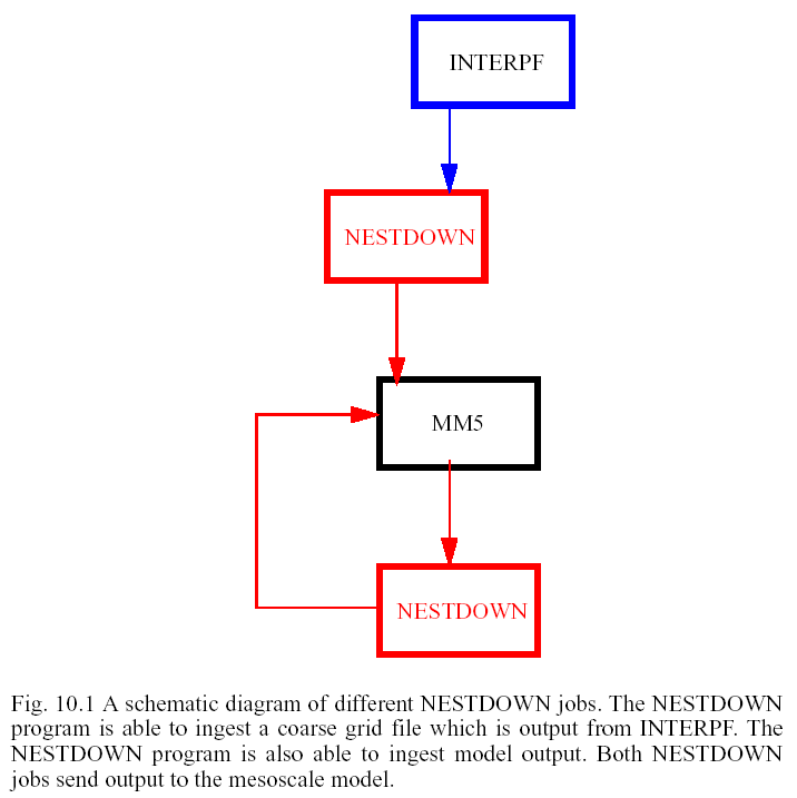
The NESTDOWN program horizontally interpolates σ−coordinate data, from a coarse grid to a fine grid. Modifying the number of vertical levels or their spatial distribution is permitted, usually for the purpose of increasing vertical resolution to complement a finer horizontal grid. The input data is on a σ-coordinate, either output from the mesoscale model or the initial condition file for model input. The output remains on the σ−coordinate. The program requires that the fine grid TERRAIN data be made available as input. Optionally, the coarse-grid lower boundary file may be required.
If this program is being used to produce a higher resolution model run from a coarse grid, there are several advantages: 1) the model has lateral boundary conditions that use consistent physics with the coarse grid model; 2) the lateral boundary conditions are available at a relatively high temporal frequency; 3) the vertical structure of the atmosphere is not significantly modified through vertical interpolation. Without the inclusion of observations, though, the model is able to drift.
The NESTDOWN program runs on the following platforms: Compaq/Alpha, Cray, DEC, HP, IBM, SGI, Sun, PCs running Linux (Fedora with PGI or Intel compilers), and MAC (OSX with xlf). The NESTDOWN code is written in FORTRAN 90.
The base state computation is handled identically to that described in Chapter 7 INTERPF. However, two base states are computed: one for the coarse grid and one for the fine grid. The only difference between the two is the terrain elevation, as all of the other constants use the same values (P00, Ts0, A, PTOP, TISO). If vertical nesting is requested, then the base state for the new sigma level distribution is also computed, but only for the fine grid.
All of the MM5 system job decks for NCAR IBMs are written as C-shell executables. Strict adherence to C-shell syntax is required in this section.
Most of the available options for the NESTDOWN code are handled through the namelist input file. Since this is a FORTRAN namelist (a FORTRAN 90 standard), syntax is very strict. There are five namelist records for NESTDOWN. There are no default values, the entire namelist must be correctly modified for each program execution. However, there are a few values that do not often need to be changed.
|
T/F flag of whether to force less than 24 h in the analysis (FALSE by default) |
There are several horizontal interpolation options used inside NESTDOWN, though the user is only allowed to control the selection of positive definite (slow) vs. overlapping parabolic (faster). If the user selects a 3:1 ratio in the TERRAIN program, a tailored 3:1 interpolator is employed. Other ratios require the BINT function. For masked fields, a linear 4-point interpolation is selected if all four surrounding points are valid. If at least one of the points is inappropriate for a masked interpolation and at least one of the points is valid, then an average of the possible data points (of the four surrounding values) is computed. Masked fields with no valid surrounding points have various default values based on the field name.
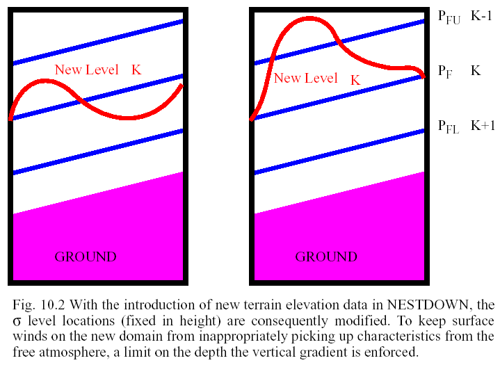
The horizontal interpolation takes place on σ coordinates. With the introduction of the fine grid terrain elevation data, there are locations with a significant extent of orographic change. The 3D temperature, 3D mixing ratio, 2D ground temperature, and the 2D soil temperatures are slightly modified to reduce the initial imbalance the model will feel with these fields.
The air temperature and ground temperature adjustments are based upon the difference in the reference temperature change at the particular (i,j,k) location. The "F" subscript is the new variable with fine grid terrain elevation, the "C" subscript denotes the coarse terrain values, and the "R" refers to the reference temperature. Other than a few constants, the reference temperature differences are a function of terrain elevation differences only. For the ground temperature and soil temperature adjustments, the lowest σ level value of the reference temperature difference is used as the correction.
 |
(10.1) |
The original fine grid mixing ratio, computed with the original fine grid temperature, is converted to relative humidity. This is re-diagnosed as mixing ratio, but using the adjusted fine grid temperature. Essentially, RH is conserved.
The option to modify the horizontal winds based on the elevation differences from the horizontally interpolated terrain elevation and the fine grid input terrain is currently commented out, which matches the treatment given to fine grid domains initialized within MM5.
1. restrict the vertical extrapolation to only 1 level at most
 |
(10.2) |
1) Obtain the source code tar file from one of the following places:
ftp://ftp.ucar.edu/mesouser/MM5V3/NESTDOWN.TAR.gz
/MESOUSER/MM5V3/NESTDOWN.TAR.gz
3) Type `make' to create an executable for your platform.
4) On the NCAR IBMs, edit nestdown.deck.ibm (located in ~mesouser/MM5V3/IBM) to select script options and to select namelist options. On a workstation, edit the namelist.input file for the namelist options.
5) On the NCAR IBMs, type nestdown.deck.ibm to compile and execute the program. It is usually a good practice to redirect the output to a file so that if the program fails, you can take a look at the log file. To do so, type: nestdown.deck.ibm >& nestdown.log, for example. On a workstation, or on a IBM running interactively, run the executable directly (nestdown >& nestdown.log).
Either MMINPUT_DOMAINn or MMOUT_DOMAINn
where n is the coarse grid domain identifier on input and m is the fine grid domain identifier. The location of the input files (directory information) is provided in the namelist.input file.
where m is the fine grid domain identifier on output. These files are created in the current working directory. The user has no control over the naming convention.
The NESTDOWN program has input and output files that are ingested and created during the program execution. The gridded input files and all of the output files are unformatted FORTRAN (binary, sequential access). One of the input files is a human-readable namelist formatted file of run-time options.
The following tables are lists of input and output units for the NESTDOWN program.
|
optional input file, contains the coarse grid reservoir temperature and mean SST |
|
|
fine grid lower boundary condition (reservoir temperature and mean SST) |
The nestdown.tar file contains the following files and directories:
CHANGES |
Description of changes to the NESTDOWN program |
Makefile |
Makefile to create NESTDOWN executable |
|
README |
General information about the NESTDOWN directory |
|
namelist.input |
Namelist file containing run-time options |
|
nestdown.deck |
Job deck for usage on one of NCAR's Crays |
|
src/ |
NESTDOWN source code |