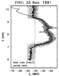
This figure is an altitude profile through a cirrus cloud of simultaneous measurements by the replicator and the NOAA K-band radar, acquired during the 1991 FIRE-II experiment in Coffeyville, Kansas. The dots are individual radar measurements of Equivalent Radar Reflectivity Factor (Ze) for a 15 minute period that encompassed a replicator ascent through the cloud. The spread in the radar data at a given altitude indicates the horizontal variability in Ze as the cloud advected over the radar, and the bold line is the mean Ze at a given altitude during the time period. The lighter line is Ze calculated from the replicator measurements of crystal size and shape, at 28 levels in the cloud. The excellent agreement is, among other things, validation of new relationships for calculating a crystal's mass from its size and shape. The dashed line at -40 dBZ is approximately the radar's detection threshold at the cloudtop altitude, and it is apparent from the replicator data that the radar is unable to detect the upper 800 m of the cloud because the reflectivity is low (due to small crystals at cloudtop, which is typical of cirrus). The shape of this Ze profile is typical of cirrus, and results from the growth of crystals as they fall through ice-supersaturated air from their formation at cloudtop, until they begin to sublimate in drier air in the lower portion of the cloud.