
|
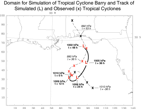
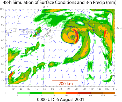
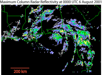
A 48-h simulation of a tropical cyclone for a stage prior and approximately up to the landfall of the observed tropical cyclone Barry (2001) was performed using the mass-coordinate version of the WRF model. This simulation utilized 10-km horizontal grid spacing, the Betts-Miller-Janic cumulus (cu_physics = 2), NCEP simple ice microphysics (mp_physics = 3), and MRF PBL (bl_pbl_physics = 1) paramterization schemes. The model horizontal domain and both the simulated and observed tracks of the storm are displayed in Fig. 1. After the first 12 h of simulation, the observed cylone (denoted by red x symbols) and the simulated cyclone (denoted by the red L symbols) follow similar northward tracks. The observed storm made landfall 5 h after the simulation ended (note the black x symbol near NW coastal Florida in Fig. 1). Although the track of the simulated storm was similar to the observed, it's central surface pressure was less deep. This may be due in part to the lowest pressure being ~10 hPa higher in the ETA 40-km analysis (used to initialize the model) than was observed at 0000 UTC 04 August 2001 (not shown). The simulated precipitation pattern at 0000 UTC 06 August 2001 (t = 48 h) shown in Fig. 2 is similar to observations at the same time (Fig. 3), 5 h prior to landfall. Both contain a large area of precipitation over the northeastern Gulf of Mexico and the ajacent Florida land mass and southern Gulf coast states, with a concentration of strong spiral bands located close to the storm center (e.g., Fig. 2). Click here to download this dataset. |
|
|