
|
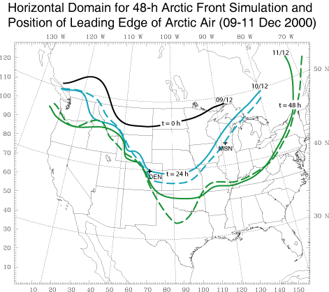
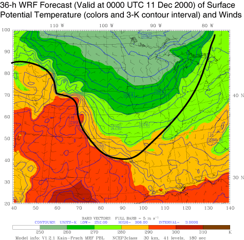
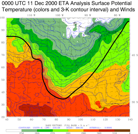
The mass coordinate version of the WRF model was used to simulate a shallow arctic cold front which advanced southward and eastward in the lee of the Rocky Mountains during a 48-h period from 1200 UTC 9 December to 1200 UTC 11 December 2000. This simulation employed 30-km horizontal grid spacing and was run with the Kain-Fritsch cumulus (cu_physics = 1), NCEP simple microphysics (mp_physics = 3), and the MRF boundary layer (bl_pbl_physics = 1) parameterizations. The model horizontal domain and the advance of the leading edge of the arctic air are shown in Fig. 1. During the 48-h of simulation the westward progression of the shallow front is retarded in the central and southern Rockies but moves rapidly southward along the eastern edge of the mountains and adjacent high plains during the first 36 h and then eastward through the upper midwest during the final 24 h of simulation. Observations of the frontal positions at 24 and 48 h (dashed lines in Fig. 1 and bold lines in Figs. 2 and 3) and a comparison of the surface potential temperatures and winds from WRF at t = 36 h (Fig. 2) and the ETA analysis (Fig. 3) from the same time (0000 UTC 11 December) illustate the general success of the simulation in capturing a strong surface temperature drop, and its approximate timing, associated with the frontal passage. However, close to the Rockies near DEN (location shown in Fig. 1), and southeastward, the advance of arctic air is slow compared with observations. Some aspects of the simulated diurnal temperature cycle in the immediate lee of the southern Rockies prior to frontal passage are also not completely captured by the model (not shown). Click here to download this dataset. |
|
|