
|
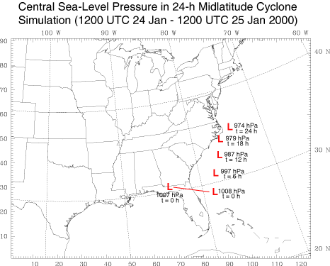
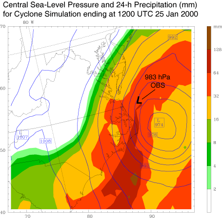
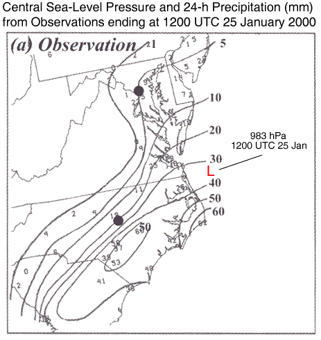
A 24-h simulation was performed for a coastal winter cyclone that produced heavy snow over portions of the midatlantic states on 25 January 2000. The mass-coordinate version of the WRF model was run at 30-km horizontal grid spacing, and utilized the Kain-Fritsch cumulus (cu physics = 1), MRF boundary layer (b1_pbl_physics = 1), and NCEP 3-class microphysical (mp_physics = 3) parameterizations. The horizontal domain of the model and the 24-h track of the simulated surface cyclone are displayed in FIG. 1. FIGURE 2 depicts the surface cyclone after 24 h of simulation. The central pressure of 974 hPa is 9 hPa deeper and located ~100 km southeast of that analyzed by Zhang et al. (Monthly Weather Review, 2002, 1617-1632) from observations. In general, the simulated 24-h accumulated precipitation pattern compares favorably with observations in FIG. 3 (from Zhang et al.). However, the simulation fails to capture some important details including 1) an inland local precipitation maximum extending southwestward from southeaster North Carolina into eastern South Carolina and 2) the westward extent of the precipitation, which was influencing Washington D.C. (the northernmost dot in Fig. 3) by 1200 UTC 25 January. Deficiencies of a similar nature in deterministic operational forecasts of this major winter precipitation event have been been reported by several investigators including Langland et al. (Monthly Weather Review, 2002, 957-974), Buizza and Chessa (Monthly Weather Review, 2002, 1531-1551), and Zhang et al.. Click here to download this dataset. |
|
|