Land-Surface Models in MM5 Version 3
How to run Noah LSM
Since Version 3.6, the Oregon State University / NCEP Eta Land-Surface
Model (OSU LSM) in MM5 (Chen and Dudhia 1999) has been replaced
by an updated version of the model, known as the Noah LSM, which
includes many improvements from NCEP, NCAR, AFWA and UCLA. Like
the OSU LSM, using the Noah LSM option in MM5 requires additional
inputs to initialize the model.
1. Noah LSM Requirements in Model Pre-Processing System
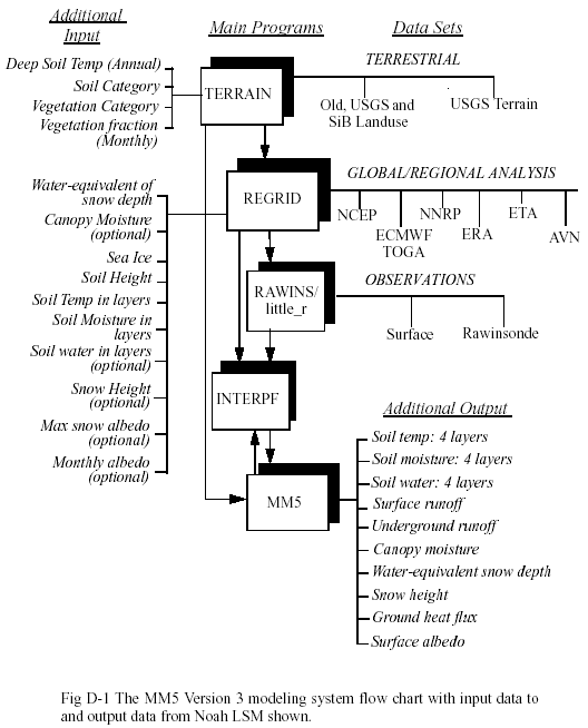
To use the Noah LSM option, the MM5 model requires several additional
input fields. The Version 3 TERRAIN program provides an annual-mean
deep soil temperature adjusted to model terrain elevation, a monthly
climatological vegetation fraction, dominant soil type, and dominant
vegetation type in each grid cell. All of the inputs to the TERRAIN
program are provided by mesouser.
The REGRID program provides soil moisture, soil temperature
at various depths, water-equivalent snow depth, sea ice, and optionally
canopy moisture and soil water content. These additional fields
are currently available from the NCEP/NCAR Reanalysis (NNRP, 2.5
degree resolution over past 40 more years), NCEP's global Final
Analyses (FNL, 1.0 degree resolution since Sept 1999) and the Eta
AWIP analyses (for the Continental US only, about 40 km resolution
since May 1995). These datasets are archived at NCAR. The additional
soil data are also available in real-time from NCEP's ftp site from
Eta and AVN model outputs (ftp://ftpprd.ncep.noaa.gov/pub/data/nccf/),
or from AFWA-produced AGRMET data (http://www2.mmm.ucar.edu/mm5/doc.html).
These input data are illustrated in Fig. D-1.
Two additional types of input can be ingested in the REGRID/regridder
program as well: 1-degree global maximum snow albedo, and 0.15-degree
monthly climatological (snow-free) albedo. The recommendation is
to use the maximum snow albedo (which is used in the Noah LSM to
limit values of albedo when snow is present), and use the climatological
albedo with caution (for example, one may want to only use this
field when the grid size is above the data resolution which is about
16 km). These two datasets are provided by mesouser. The maximum
snow albedo data are provided in REGRID tar file (REGRID/regridder/ALMX_FILE),
and one can obtain monthly albedo from:
ftp://ftp.ucar.edu/mesouser/MM5V3/REGRID_DATA/MONTHLY_ALBEDO.TAR.gz
or on MSS:
/MESOUSER/DATASETS/REGRID/MONTHLY_ALBEDO.TAR.gz
All LSM fields are passed along in programs RAWINS/LITTLE_R
and INTERPF.
2. How to Set Program Switches to Run LSM
Terrain -
In terrain.deck, set namelist variable
LSMDATA = .T.,
and select values 1 or 2 for VEGTYPE. e.g.,
VEGTYPE = 1,
(In V3.3 or earlier terrain.deck, select
set NewLandUseOnly = FALSE
set LandSurface = TRUE
and either
set VegType = USGS
or
set VegType = SiB
The rest of the terrain.deck is the same.)
Note that SiB data is only available for North America, but these
categories corresepond to those used in the Eta model's operational
LSM. However, either set can be used in MM5's version of the LSM.
Also, note that the SiB classification lacks an `urban' category.
These setups will make use of the terrestrial datasets to create
the following additional fields on the model grid in the TERRAIN
output:
1. VEGFRCnn (nn=1,12): vegetation fraction monthly climatology
2. TEMPGRD: annual mean ground temp adjusted to model terrain elevation
3. SOILINDX: dominant soil type (currently 30" over US, 5-minutes
elsewhere)
Note, for soil types, one may choose either soil type data over
top layer (0 - 30 cm), or bottom layer (30 - 100 cm). Selecting
the bottom soil data can be done by uncommenting the script variable
BotSoil near the top of terrain.deck. A comparison of top
and bottom soil types over the continental US may be found online
at http://www2.mmm.ucar.edu/mm5/mm5v3/new-soil.html.
REGRID -
The datasets that have the required additional fields to run Noah
LSM in MM5 are Eta (AWIP or Eta212 grid), NNRP and NCEP's FNL data
archived at NCAR (DSS609.2, DSS090.0, and DSS083.2, respectively).
Real-time data from NCEP's Eta and AVN can also be used.
To get the NNRP data from NCAR archive, use either get_nnrp.deck.ibm
for batch IBM job, or get_nnrp.csh for running interactively
from pregrid/nnrp directory.
To get the FNL data from NCAR archive, go to http://dss.ucar.edu/datasets/ds083.2/inventories/,
and download individual files as needed.
There isn't a deck or script to get NCAR archived AWIP data at
this time. But you can do the following to obtain the data (Note
that the Eta dataset only covers Continental US. It starts May 1995,
and may have missing periods):
1. Use Web browser to go to
ftp://ncardata.ucar.edu/datasets/ds609.2/inventories/eta.inv
and find out which Gxxxxx file contains the time period of your
interest. Should get both 3Danal and SFanal files.
2. On NCAR's computer, type the following to get the dataset in
non-cos-blocked format:
msread -fBI Gxxxxx /DSS/Gxxxxx
(You may then ftp this file back to your local workstation to do
the rest. Note though these files are very BIG in size: the 3Danal
file is about 1Gb each, and SFanal is about 250 mb. If ftping big
file is a problem, do steps 3 and 4 on Cray, and ftp the files after
step 4.)
3. Type the following to obtain all file listed in the Gxxxxx file:
tar tvf Gxxxxx > tar.list
Or find out the files from
ftp://ncardata.ucar.edu/datasets/ds609.2/inventories/TARLIST
and click on the appropriate tarlist file.
4. Extract the tmXX files to use by typing, using G40001 (containing
upperair data) and G40006 (containing surface data) files as an
example:
tar -xvf G40001 9706_3Danal/97062400.AWIP3D00.tm00
and
tar -xvf G40006 9706_SFanal/97062400.AWIPSF00.tm00
Repeat the last two commands several times to obtain all time periods.
The tm00 files are to be used by pregrid program. (If one wants
to use other tmXX files, please refer to the DSS document at http://dss.ucar.edu/datasets/ds609.2/docs/awip212.html.)
The extracted file for each time period is considerably smaller
in file size: about 5 Mb each for upperair data and 1.2 Mb for surface
data. You can ftp each file back to your workstation, or tar them
up and then ftp the file back. Note, if you would like to run REGRID
on NCAR's IBM using AWIP dataset, you can either run the job interactively
if your domain size is not too big (IBM allows for 32 Mb of memory
for interactive job only), or you can modify the deck to extract
the files only.
In pregrid.csh make sure you have either Eta (AWIP or Eta212
grid), or NNRP, or FNL data for the relevant dates, set SRCSOIL
to either $SRC3D or different input files, and:
set VTSOIL = ../grib.misc/Vtable.AWIPSOIL
or
set VTSOIL = ../grib.misc/Vtable.NNRPSOIL
or
set VTSOIL = ../grib.misc/Vtable.AVNSOIL
For snow data, you will need to set SRCSNOW for input files
and use one of the Vtable file for VTSNOW (Vtable.AWIPSNOW,
or Vtable.NNRPSNOW, or Vtable.AVNSNOW).
If you have other LSM data, check the Vtables above to see
which fields that may be used. The fields added to the standard
meteorological fields by setting SRCSOIL (and SRCSNOW)
are:
1. SOILTnnn: Soil temp at various depths (nnn are in cm; unit:
K)
2. SOILMnnn: Soil moisture at various depths (nnn are in cm; unit:
fraction)
3. SOILHGT: Analysis surface elevation, used in REGRID to
adjust soil temp (unit: m)
4. WEASD: Water-equivalent snow depth (optional but highly desirable;
unit: kg m{-2})
5. SEAICE: Sea-ice mask (optional but highly desirable; 0 or 1)
6. SOILWnnn: Soil water (optional and currently from AGRMET only;
unit: m3/m3)
where nnn is equal to 010, 040, 100 and 200 (10, 40, 100
and 200 cm, respectively) for various datasets we support. Among
these fields, only the soil temperature, soil moisture, and soil
height fields are required by the Noah LSM option. But we recommend
that fields WEASD and SEAICE are made available. If
your LSM data contain fields at levels other than those listed,
you can still use them. For example, you may get soil temperature
at 10 and 200 cm only, or perhaps at other levels, you can modify
Vtable to extract these fields. When you run MM5, you can
use the namelist options ISTLYR and ISMLYR (available
since V3-2) to define where your data are (see below).
Since V3.6, REGRID may ingest AGRMET LSM data. This dataset
is produced by AFWA, and made available to MM5 users since October
2002 (with two months delay in real-time). The data are archived
at NCAR on MSS: /MESOUSER/DATASETS/AGRMET/. Vtables for this
dataset are provided in REGRID/pregrid/grib.misc/Vtable.AGRMETxxxx.
Soil temperature, moisture, water, landsea mask and soil height
fields are extracted from this dataset. One may use this dataset
in combination with other three-dimensional meteorological input.
In regridder, do not use sst_to_ice_threshold in
the namelist.input, i.e. do not turn sea water into land ice. Use
the SEAICE field in the input instead.
MM5 -
To use the Noah LSM, set ISOIL=2 in configure.user prior
to compilation. IBLTYP=4 or 5 (the Eta or MRF PBL) must be
used for now. They are the only ones coupled to the LSM.
If you have ingested climatological albedo fields from REGRID,
you may choose to use or not use them in MM5. Set the following
namelist variables to .FALSE. if you don't want to use them in the
model:
RDMAXALB = .FALSE.,
RDBRDALB = .FALSE.,
We generally recommend that one uses the climatological maximum
snow albedo only.
To use input soil temperature and moisture at levels other than
the default, one can add namelist variables ISTLYR and ISMLYR
in the namelist LPARAM section to specify these levels. For
example,
ISTLYR = 10,200,0,0,
ISMLYR = 10,200,0,0,
TThis shows that the input soil temperature only comes in at 10
and 200 cm levels. Note that one can only input up to 4 levels of
soil temperature and moisture. The prediction levels in current
MM5/Noah LSM are 5, 25, 70, and 150 cm and are bounded between surface
and 300 cm below. The climatological deep soil temperature generated
in program TERRAIN is used as the lower boundary condition
for the Noah LSM, while open-boundary condition is used for soil
moisture and soil water.
Additional Noah LSM prognostic outputs from MM5 are:
1. SOIL Tn (n=1,4): The soil temp at all 4 soil levels, unit K;
2. SOIL Mn (n=1,4): The soil moisture at all 4 soil levels, unit
m3/m3;
3. SOIL Wn (n=1,4): The soil water at all 4 soil levels, unit m3/m3;
4. CANOPYM: Canopy moisture, unit m;
5. SNOWH: Snow height, unit m;
6. WEASD: Water equivalent snow depth, unit mm;
7. SFCRNOFF: Surface runoff accumulation, unit mm;
8. UGDRNOFF: Underground runoff accumulation, unit mm;
9. GRNFLX: Ground head flux, unit W m-2;
10. ALB: Albedo, unit fraction.
Note 1: If using NNRP soil moisture, you may want to check
init.F and initnest.F, where there is a correction for
some known biases in soil moisture. Comment out GOTO 1001, and GOTO
2001 in those routines respectively, if you want to use this correction.
Note 2: If you want diagnostic LSM prints at a gridpoint,
change the line in surfce.F (SURFCE.284) to NOOUT=1 and edit the
IF statements determining where and how often to output data.
Note 3: When using NESTDOWN to generate input files
for a one-way nested run, again make sure that one doesn't use the
sst_to_ice_threshold option, and check interpolated fields
(especially those of masked fields: e.g. sea ice, snow height, soil
water, and other LSM fields) carefully.
|
