
| General Questions NCAR IBM Related Questions Terrain Regrid Datagrid Little_R Rawins MM5 Graph Conventions used in MM5 Trouble shooting and clues on various computers |
Frequently Asked QuestionsTERRAIN
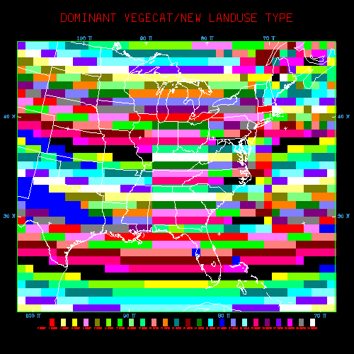
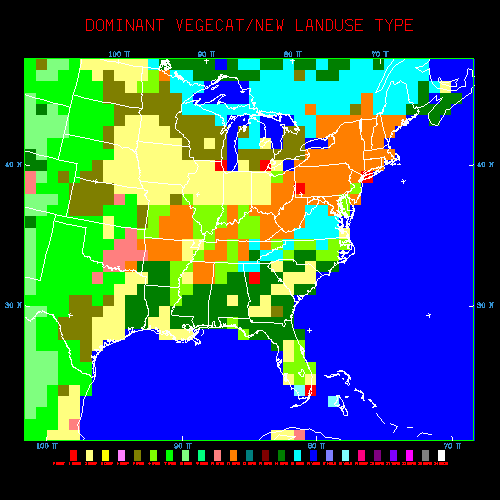
When terrain program fails, the first thing to check is to see if this line is included in your .cshrc file on NCAR's Cray: setenv NCARG_ROOT /usr/local Errors that may be associated with missing this `setenv' includes: ``ERROR 1 IN OPENMP" or ``STOP executed at line 129 in Fortran routine `SETER' ". Terrain and many of MM5 modeling system programs require this being set in the .cshrc file. Version 3 Terrain input data are available via NCAR's anonymous ftp. All data may be used on both Cray and workstations. It doesn't usually take much resource to run the Terrain program. But if you choose to use the 30-second data option, it will take a lot of memory. Approximately, it will take 1 Gb of memory to create a domain that covers a 10 deg by 10 deg area on 32-bit workstation, and nearly 240 Mw on 64-bit Cray. Yes, you can now. Version 3 and the latest V2 terrain program can be run without NCAR Graphics. Please see README file inside the tar file. Loading g77-compiled NCAR Graphics on a Linux machine with pgf77/90-compiler TERRAIN code requires a library called libf2c.a. Source code for f2c may be found on the net. If you are running RedHat 6, you can download one from our ftp site too. Please click here for information. There was a format change to the data files in version 3.5. If
you are getting a landuse plot with
diagonal stripes, rather than the landuse
plots you are use to, you are more than likely using version
3.4 data to run version 3.5 (or higher) code. You can still run TERRAIN version 3.4, but if you do, make use of the data in ftp://ftp.ucar.ed u/mesouser/MM5V3/DATA This is most often associated with a problem with one of the
30 sec input data files been corrupted. This may happen if (1)
there was a pipe break during the transfer of the data, or (2)
if you ftp-ed the data manually without specifing binary transfer
mode. |