|
Major Changes in Version 3 Pre-Processing Programs |
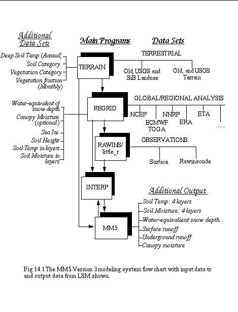
Version 3 MM5 Modeling System At A Glance4. Land-Surface Model The introduction of the Oregon State University / NCEP Eta Land-Surface Model (LSM) in MM5 (Chen and Dudhia 1999) has required that the modeling system be enhanced to allow for additional inputs and outputs. The land-surface model is capable of predicting soil moisture and temperature in four layers (10, 30, 60 and 100 cm thick), as well as canopy moisture and water-equivalent snow depth. It also outputs surface and underground run-off accumulations. The LSM makes use of vegetation and soil type in handling evapotranspiration, and has effects such as soil conductivity and gravitational flux of moisture. In MM5 it may be called instead of the SLAB model in the MRF PBL, taking surface-layer exchange coefficients as input along with radiative forcing, and precipitation rate, and outputting the surface fluxes for the PBL scheme. This scheme uses a diagnostic equation to obtain a skin temperature, and the exchange coefficients have to allow for this by use of a suitable molecular diffusivity layer to act as a resistance to heat transfer. In the future we expect to add several more land-surface models, such as BATS, PLACE, RUC's LSM and CCM3's LSM, and to couple them to more surface-layer/ boundary-layer schemes.
4.1 LSM Requirements in Model Pre-Processing System To operate with the LSM, MM5 requires several additional input fields. The Version 3 Terrain program provides an annual-mean surface temperature adjusted to terrain elevation, a monthly climatological vegetation fraction, dominant soil type, and dominant vegetation type in each grid cell. The Regrid program provides soil moisture and temperature at various depths, water-equivalent snow depth, sea ice, and optionally canopy moisture. Currently available sources of such fields are from the NCEP/NCAR Reanalysis, and the Eta AWIP analyses (for the US only). These input data are illustrated in figure below. 4.2 How to Set Program Switches to Run LSM Terrain In terrain.deck select set NewLandUseOnly = FALSE and either set VegType = USGS or set VegType = SiB The rest of the terrain deck is the same. Note that SiB is only available for North America, but these categories corresepond to those used in the Eta model's operational LSM. However, either set can be used in MM5's version of the LSM. Also, note that the SiB classification lacks an 'urban' category. These setups will make use of global datasets to create the following additional fields on the model grid: 1. VEGFRCnn (nn=1,12): vegetation fraction monthly climatology 2. TEMPGRD: annual mean ground temp adjusted to model terrain elevation 3. SOILINDX: soil type (currently only 30" over US, 1 deg elsewhere) REGRID The datasets that have required additional fields to run LSM in MM5 are either Eta (AWIP or Eta212 grid) or NNRP data. To get the NNRP data from NCAR archive, use either get_nnrp.deck for batch Cray job, or get_nnrp.csh for running interactively from pregrid/nnrp directory. There isn't a deck or script to get NCAR archived AWIP data. But you can do the following to get the data (Note the Eta dataset only covers US. It starts May 1995, and may have missing periods): 1. Use Web browser to go to ftp://ncardata.ucar.edu/datasets/ds609.2/inventories/eta.inv and find out which Gxxxxx file contains the time period of your interest. Should get both 3Danal and SFanal files. 2. On NCAR's Cray, type the following to get the dataset in non-cos-blocked format: msread -fBI Gxxxxx /DSS/Gxxxxx (You may then ftp this file back to your local workstation to do the rest. Note though these files are very BIG in size: the 3Danal file is about 1Gb each, and SFanal is about 250 mb. If ftping big file is a problem, do steps 3 and 4 on Cray, and ftp the files after step 4.) 3. Type the following to obtain all file listed in the Gxxxxx file: tar tvf Gxxxxx > tar.list Or find out the files from ftp://ncardata.ucar.edu/datasets/ds609.2/inventories/TARLIST and click on the appropriate tarlist file. 4. Extract the tmXX files to use by typing, using G40001 (containing upperair data) and G40006 (containing surface data) files as an example: tar -xvf G40001 9706_3Danal/97062400.AWIP3D00.tm00 and tar -xvf G40006 9706_SFanal/97062400.AWIPSF00.tm00 Repeat the last two commands several times to obtain all time periods. The tmXX files are to be used by pregrid program. The extracted file for each time period is considerably smaller in file size: about 5 Mb each for upperair data and 1.2 Mb for surface data. You can ftp each file back to your workstation, or tar them up and then ftp the file back. Note, if you would like to run REGRID on Cray using AWIP dataset, you can either run the job interactively if your domain size is not too big (Cray allows 32 Mw of memory for interactive job only), or you need to modify the deck to get your extracted files. In pregrid.csh make sure you have either Eta (AWIP or Eta212 grid) or NNRP data for the relevant dates and set SRCSOIL and either set VTSOIL = ../grib.misc/Vtable.AWIPSOIL or set VTSOIL = ../grib.misc/Vtable.NNRPSOIL For snow cover you will also want SRCSNOW and Vtable.AWIPSNOW, or Vtable.NNRPSNOW for VTSNOW. Eta data is only available over the US for recent years and has 40 km resolution. NNRP is available globally for the past 40 years or more, but has about 2.5 deg resolution. If you have other LSM data, check the Vtables above to see which fields are required. The fields added to the standard meteorological fields by setting SRCSOIL (and SRCSNOW) are: 1. SOILT010, SOILT200, SOILT400: Soil temp at various depths (10, 200, and 400 cm; unit: K) 2. SOILM010, SOILM200: Soil moisture at various depths (10 and 200 cm; unit: fraction) 3. SOILHGT: Analysis surface elevation (unit: m) 4. SEAICE: Sea-ice mask (optional; 0 or 1) 5. WEASD: Water-equivalent snow depth (optional; unit: kg m{-2}) If your LSM data contain fields at levels other than those listed, you can still use them. For example, you may get soil temperature at 10 and 200 cm only, or perhaps at other levels, you can modify Vtable to extract these fields. Later when you run MM5, you can use the new namelist options ISTLYR and ISMLYR (available in 3-2) to define where your data are. The current default prediction levels for soil temperature and moisture in MM5/LSM are bounded between surface and 300 cm below the surface, and there are 4 levels for each variable. MM5 To use the LSM, set ISOIL=2 in configure.user prior to compilation. IBLTYP=5 (the MRF PBL) must be used for now. It is the only one coupled to the LSM. To use input soil temperature and moisture at levels other than the default, one can add namelist variables ISTLYR and ISMLYR in LPARAM section to specify these levels. For example, ISTLYR = 10,200,0,0, ISMLYR = 10,200,0,0, This shows that the input soil temperature only comes in at 10 and 200 cm levels. Note that one can only input up to 4 levels of soil temperature and moisture. The prediction levels in current MM5/LSM are 5, 25, 70, and 150 cm. The climatological deep soil temperature generated in program Terrain is used as the lower boundary condition for LSM, while open-boundary condition is used for soil moisture. Additional LSM outputs are: 1. SOIL Tn (n=1,4). The soil temp at all 4 soil levels. 2. SOIL Mn (n=1,4). The soil moisture at all 4 soil levels. 3. CANOPYM. Canopy moisture. 4. SNODPTH. Snow depth. 5. SFCRNOFF. Surface runoff accumulation. 6. UGDRNOFF. Underground runoff accumulation. Note 1: If using NNRP soil moisture, you may want to check init.F and initnest.F, where there is a correction for some known biases. Comment GOTO 1001, and GOTO 2001 in those routines respectively, if you want to use this correction. Note 2: If you want diagnostic LSM prints at a gridpoint, change the line in surfce.F (SURFCE.241) to NOOUT=0 and edit the IF statements determining where and how often to output data to unit 29. Note 3: If you are making a nest run with LSM option, we recommend that you generate input files for all domains, especially when you are not running objective analysis package. The current nest initialization options in MM5, IOVERW = 0, or 2, do not yet interpolate masking fields correctly. This problem will be addressed. |