A Program for Visualizing
Mesoscale Model Output
Mark
T. Stoelinga
University of Washington
May
2008
      |
Table of Contents
- Introduction
- Setting up RIP on your system
- Preparing data with RIPDP
- The RIP user input file
- Running RIP
- Calculating and plotting trajectories
- Creating a data set for Vis5D
- Other special situations
Appendix
A. Keywords
Appendix B. Available fields
for plotting
Appendix C. Format of RIP data
files
RIP (which stands for Read/Interpolate/Plot) is a
Fortran program that invokes NCAR Graphics routines for the purpose of
visualizing output from gridded meteorological data sets, primarily from
mesoscale numerical models._ It was originally designed for
sigma-coordinate-level output from the PSU/NCAR Mesoscale Model (MM4/MM5), but
was generalized in April 2003 to handle data sets with any vertical coordinate,
and in particular, output from the Weather Research and Forecast (WRF) modeling
system. It can also be used to visualize model input or analyses on model
grids. It has been under continuous development since 1991, primarily by Mark
Stoelinga at both NCAR and the University of Washington. RIP is an officially
supported component of the WRF modeling system, but could potentially be used
with output from any mesoscale model.
The program is designed to be portable to any UNIX system that has a Fortran
77 or Fortran 90 compiler and the NCAR Graphics library. The UNIX operating
system is not necessarily a requirement, but this document is written with the
assumption that you are working on a UNIX system. The author has not given a
considerable amount of thought to problems that may arise on another operating
system.
RIP can be described as "quasi-interactive". You specify the
desired plots by editing a formatted text file. The program is executed, and an
NCAR Graphics output file is created. The plots can be modified, or new plots
created, by changing the user input file and re-executing RIP. Some of the
basic features of the program are outlined below:
- uses a preprocessing program (called RIPDP) which reads model output, and converts this data into standard RIP format data files that can be ingested by RIP. Three versions of RIPDP are provided: one for output from the MM5 Modeling System, one for output from the Advanced Research WRF (ARW) version of the WRF model, and one for output from the Nonhydrostatic Mesoscale Model (NMM) version of the WRF model. Other versions of RIPDP could potentially be constructed to ingest output from other mesoscale models.
- makes Lambert Conformal, Polar Stereographic, Mercator, or stretched-rotated-cylindrical-equidistant (SRCE) map backgrounds, with any standard parallels.
- makes horizontal plots of contours, color-filled contours, vectors, streamlines, or characters.
- makes horizontal plots on model vertical levels, as well as on pressure, height, potential temperature, equivalent potential temperature, or potential vorticity surfaces.
- makes vertical cross sections of contours, color-filled contours, full vectors, or horizontal wind vectors.
- makes vertical cross sections using vertical level index, pressure, log pressure, Exner function, height, potential temperature, equivalent potential temperature, or potential vorticity as the vertical coordinate.
- makes skew-T/log p soundings at points specified as grid coordinates, lat/lon coordinates, or station locations, with options to plot a hodograph or print sounding-derived quantities.
- calculates backward or forward trajectories, including hydrometeor trajectories, and calculates diagnostic quantities along trajectories.
- plots trajectories in plan view or vertical cross sections.
- makes a data set for use in the Vis5D visualization software package
- allows for complete user control over the appearance (color, line style, labeling, etc.) of all aspects of the plots
2. Setting up RIP on your system
a. Obtaining and unpacking the code and related files
The most recent version of the code can be downloaded from NCAR's WRF ARW
download web page (registration required), or from NCAR's PSU/NCAR Mesoscale Model ftp
site. Download the compressed tar file, RIP4.TAR.gz, to your local machine,
and uncompress the file (i.e., gunzip RIP4.TAR.gz).
The tar file contains a top-level directory called RIP, in which all the
RIP-related files reside. Unpacking the tar file (i.e., running tar xf RIP4.TAR) will create a RIP
directory, as a subdirectory of your current working directory, and will place
all the RIP-related files in that new RIP directory. Thus, before unpacking the
RIP tar file, you should first change to a directory that you want to be the
parent directory of your RIP directory. This would commonly be your home
directory. The tar file contains the following directories and files:
- CHANGES, a text file that logs changes to the RIP tar file.
- Doc/, a directory that contains documentation of RIP, most notably the HTML version of the Users' Guide that you are now reading (ripug.htm).
- Makefile, the top-level make file used to compile and link RIP.
- README, a text file containing basic information on running RIP.
- color.tbl, a file that contains a table defining the colors you want to have available for RIP plots.
- eta_micro_lookup.dat, a file that contains "look-up" table data for the Ferrier microphysics scheme.
- psadilookup.dat, a file that contains "look-up" table data for obtaining temperature on a pseudoadiabat.
- sample_infiles/, a directory that contains sample user input files for RIP and related programs. As of this version of the User' Guide, these files include bwave.in, grav2d_x.in, hill2d.in, qss.in, rip_sample.in, ripdp_wrfarw_sample.in, ripdp_wrfnmm_sample.in, sqx.in, sqy.in, tabdiag_sample.in, and tserstn.dat.
- src/, a directory that contains all of the source code files for RIP, RIPDP, and several other utility programs. Most of these are Fortran 77 source code files with extension .f. In addition, there are:
- a few .h and .c files, which are C source code files.
- comconst, commptf, comvctran, and CMASSI.comm, which are include files that contain common blocks that are used in several routines in RIP.
- pointers, an include file that contains pointer declarations used in some of the routines in RIP.
- Makefile, a secondary make file used to compile and link RIP.
- stationlist, a file containing observing station location information.
b. The RIP_ROOT environment variable
An important environment variable for the RIP system is RIP_ROOT._ RIP_ROOT
should be assigned the path name of the directory where all your RIP program
and utility files (color.tbl, stationlist, lookup tables, etc.) reside. If you unpacked the
RIP tar file in your home directory, then the natural choice for your RIP_ROOT
directory is the RIP subdirectory that was created when you unpacked the RIP
tar file.
For simplicity, you should define RIP_ROOT in one of your UNIX start-up
files. For example, if you use c-shell, and you have unpacked your RIP files
into a directory called /users/johndoe/RIP,
and that is where you intend to have the code and utility files reside, you
should include in your .login or .cshrc file the line
setenv RIP_ROOT /users/johndoe/RIP
RIP uses the system call getenv to
retrieve the value of RIP_ROOT from within the program. If your system's
Fortran does not support the system call getenv, you can use instead the variable rip_root in the &userin namelist in the RIP user input file (UIF) to tell
RIP where to find the utility files. This is described in more detail in Chapter 4 of the Users' Guide.
In general, the utility files mentioned above require no editing or user
input. The exceptions to this are the color table file, color.tbl, which allows you to define colors that will be used
by RIP, and the observing station listing file, stationlist, which provides location information for observing
stations that may be referenced in various aspects of the plot request._ These are described below.
c. Changing the color table file
As you become more familiar with how RIP uses colors, you may want to
customize color.tbl to suit your own
preferences. In the color table, colors are defined according to fractions of
red, green, and blue, with each fraction being a number from 0.0 to 1.0. Each
color is given a name. You can define up to 256 different colors, but RIP will
warn you if you define more than 200, because RIP also needs to make use of the
256 available color slots to define color shades for color-filled contour
plots. The basic structure of the table is as follows. The first four lines are
ignored – they are simply a banner that says that this is the color table. The
first two colors should always be given the names def.background and def.foreground, in that order. However, their color fractions can
be changed if desired. def.background is the color used by NCAR Graphics for any regions where no plotting
instructions have been given (i.e. the default background color). def.foreground is the color used by NCAR Graphics for any plotting
instructions in which you did not explicitly ask for a particular color (i.e.
the default foreground color). Usually these are either black and white, or
white and black, but the fractions can be changed to make them different
colors, as already mentioned above. It is recommended that, regardless of the
colors you use for def.foreground
and def.background, you also have
those colors defined with their appropriate names somewhere else in the table.
For example, even if color indices 0 and 1 are given the fractions 0.0,0.0,0.0
and 1.0,1.0,1.0, there should also be colors named black and white with the
same fractions somewhere else in the table. The explicitly named black or white
should be used when you want things to be black or white. That way, if you
change def.foreground or def.background to something else, the things that should remain
black and white won't change color. The table should end with a line that
contains several consecutive minus signs.
To give the user added flexibility, and for compatibility with previous versions of RIP, the user can place a color table (like the one that appears in color.tbl) directly into a RIP user input file (UIF). This allows the user to define different color tables that are unique to a particular UIF. The color table should be placed between the namelist section and the plot specification table in the UIF. If you run RIP with a UIF that contains a color table, RIP will recognize that color table and read it instead of (NOT in addition to) the color table in your RIP_ROOT directory.
Finally, there are a few important things that you should be aware of if you
will be translating your CGM plots to postscript:
- Postscript has no concept of "background color". Hence, regardless of what your index 0 color is, translation to postscript (either mono or color) will result in a blank or white background. If this is a problem, it can be circumvented by using the -simulatebg option on the ctrans command line.
- If you translate to mono postscript, all plotting instructions, regardless of the color used (black, white, red, blue, etc.), will come out black. This means any filled areas, regardless of color or color index used, will waste large amounts of toner when printed out.
- If you translate to color postscript, some monochromatic printers have the nice feature that they convert all colors to halftone gray shades.
d. Changing or adding station listings in the stationlist file
Any number of additional stations can be added to the station listing. The
important thing is to keep the station information properly lined up in the appropriate
columns. The important pieces of information to enter are the verbal
description of the location (under column "Location"), the ICAO
four-letter code identifying the station (under column "ICAO"), the
latitude and longitude (under columns "Lat" and "Lon"), and
the WMO number of the station (under column "WMO#"). The other
information is not read by RIP. Elevation should be entered if you have it,
because it may be used in the future. The author is unsure of the meaning of
the information in the third column. If the WMO number is unknown or the
station has no WMO number, enter "00000" in that column.
e. Compiling RIP and associated programs
RIP should be compiled with the UNIX make utility. There is a top-level make file, called Makefile, in the RIP/ directory, as well as a secondary Makefile in the RIP/src/ directory, that are
used for "making" RIP. The make command should be executed from within the RIP/ directory. First, you should run the command make without any options, which will
show a brief help listing on how to run make to compile RIP on your particular platform. You should choose
the option that will most likely work on your platform, and then run the make
command with that option. For example, if you are on a LINUX system, type
make linux >&! make.out &
The redirecting of make print output
to the file make.out is
optional. A successful compilation will probably take several minutes. If
you have a multiprocessor machine, you may want to find out how to run make so that the machine compiles on all processors at
the same time, as this may significantly speed up the compilation wall clock
time.
If the compiling of RIP fails, it is likely that the top-level make file
needs to be customized for your particular platform. This involves editing
Makefile so that the compile and link
commands and options are correctly configured for the particular system you are
running on. There are several sections of code in the makefile that pertain do different machines. One of
these sections needs to changed, or a new one created. The important
features that need to be adjusted are the compiler flags (FFLAGS), link flags (LDFLAGS), and libraries (LIBS). The libraries should include NCAR Graphics
libraries--make sure you have the correct location for the NCAR Graphics
libraries on your system. In some cases, you may be able to use ncargf77 as the compiler (i.e., set the CF variable to ncargf77) and not worry about specifying all the specific
libraries that are required for NCAR Graphics. Regardless of how you accomplish
the linking with NCAR Graphics, it should be pointed out that the author has
found some minor problems with RIP that occur if you use a version of NCAR
Graphics that is older than 4.0. Therefore, you should try to link with NCAR
Graphics 4.0 (or later) if you have it. It should also be noted that the
RANGS/GSHHS high-resolution map background capability is only functional if you
have NCAR Graphics 4.3 (or later). RANGS/GSHHS is not the most commonly used
map background outline set, so this does not represent a significant loss of
functionality if you cannot use it.
The two versions of RIPDP for the WRF modeling system, ripdp_wrfarw and ripdp_wrfnmm, need to link to the NetCDF library. This library of
routines is used for I/O with files in the “Network Common Data
Fromat” or NetCDF, which WRF uses. The only thing the user needs to be
concerned about is that the variables NETCDFLIB and NETCDFINC in the secondary Makefile in the RIP/src/ directory are set
properly for the path names of the directories where the NetCDF library file
and include files reside, respectively.
A successful compilation will result in the creation of several object and
executable files in the RIP/src/ directory.
The make file is also set up to create symbolic links in the RIP/ directory to the actual executables in the RIP/src/ directory. In UNIX, the best way to make the
RIP program and other associated executables accessible to you, regardless of
your current working directory, is to add the path name of your RIP directory
to your executable path list (e.g., the path shell variable in c-shell). For example, if the
above-mentioned symbolic links to the RIP executables reside in the directory ~johndoe/RIP, and you use the c-shell in UNIX, then you should
add the following line in your .cshrc file:
set path = ($path ~johndoe/RIP)
With the RIP directory in your executable path, the RIP program (and other
associated utilities like ripdp) can be
accessed easily without having to put the executables in your working directory
or having to specify full path names for the executables.
f. Notes on nonstandard Fortran 77
In general, the author has attempted to adhere to Fortran 77 standards as
much as possible in writing the code. However, a few nonstandard features have
been included, which are still available in most f77 and f90 compiling systems.
- Namelists: For some I/O, RIP and RIPDP use a nonstandard feature known as a namelist. A namelist is a Fortran input file structure that is not officially standard to Fortran 77, but which is available in most Fortran 77 compilers. Namelists are placed in text files that are opened and read by the Fortran program. The basic structure of a namelist is, on the first line, the name of the namelist (preceded by an ampersand), and then on subsequent lines a series of "variable = value" constructs, each separated by commas, blank spaces, or a new line. (On some machines, commas are required, so it's safest to always use them.) The final line ends the namelist should contain the single word end preceded by an ampersand. Each variable is an actual variable that is declared in a special namelist statement inside the Fortran program. The variables can be of any type. The value of a character variable should be enclosed in single quotes, although it doesn't have to be if all the characters in the string are alpha-numeric. The value of a logical variable should be ".true." or ".false.". Arrays can be assigned multiple values separated by commas (although it has come to the author's attention that with some compilers such as Sun's Fortran 90, each array element must be separately referenced with its index in parentheses). Here is a general example of a namelist:
&samplenlist
beatles='John','Paul','George','Ringo',
(or with Sun f90,
beatles(1)='John',beatles(2)='Paul',etc.)
primenumbers=1,2,3,5,7,11,13,
flag=.true.,
&end
Not all the variables that are defined as part of
the namelist in the Fortran program need to be given values in the namelist
file that is read. Typically, all the namelist variables are assigned default
values in the program prior to the reading of the namelist file, so that they
will retain those default values if they are omitted from the namelist file.
- System calls: RIP uses the following system calls: getenv (for retrieving the value of a UNIX environment variable from within a program), iargc (for retrieving the number of command line arguments), and getarg (for retrieving command line arguments). These system calls are quite common, and should be available in the f77 and f90 compilers from Cray, Sun, SGI, DEC, and IBM. There are also calls (commented out in the standard release) to the system routine flush (for flushing the standard output buffer, so that the progress of the program can be easily monitored when standard output is being sent to a file). These were commented out because they caused problems on some compilers, but you are free to reinstate them.
- RIP has been set up in a manner that requires adjustable dimensioning of local (non-argument) arrays in subroutine driver and a few other routines in RIP, and in subroutine process in RIPDP. In other words, in subroutine driver, for example, several arrays that are not in the subroutine argument list are dimensioned with integer variables that are in the argument list. This is technically illegal in Fortran 77, but many compilers support it because it makes dynamic memory allocation possible. It is standard in Fortran 90.
- RIP uses Cray pointers. This is nonstandard Fortran 77, but is supported by most Fortran 77 and Fortran 90 compilers.
3. Preparing data with RIPDP
RIP does not ingest model output files directly. First, a preprocessing step
must be executed that converts the model output data files to RIP-format data
files. The primary difference between these two types of files is that model
output data files typically contain all times and all variables in a single
file (or a few files), whereas RIP data has each variable at each time in a
separate file. The preprocessing step involves use of the program RIPDP (which
stands for RIP Data Preparation). RIPDP reads in a model
output file (or files), and separates out each variable at each time. There are
several basic variables that RIPDP expects to find, and these are written out
to files with names that are chosen by RIPDP (such as uuu, vvv, prs, etc.). These are the variable names that RIP users
are familiar with. However, RIPDP can also process unexpected variables that it
encounters in model output data files, creating RIP data file names for these
variables from the variable name that is stored in the model output file
metadata.
When you run make, it should produce
executable programs called ripdp_mm5,
ripdp_wrfarw, and ripdp_wrfnmm. Although these are three separate programs (one for
use with MM5 model system, one for WRF-ARW, and one for WRF-NMM), they serve
the same purpose, and will be referred to collectively as ripdp. Also, the two WRF versions of ripdp may be referred to collectively as ripdp_wrf, without the arw or nmm
specification.
a. Running RIPDP
The program has the following usage:
ripdp_XXX [-n namelist_file] model-data-set-name [basic|all]
data_file_1 data_file_2 data_file_3 ...
In the above, the "XXX" refers to either "mm5",
"wrfarw", or "wrfnmm". The argument model-data-set-name
can be any string you choose, that uniquely defines this model output data set.
It will be used in the file names of all the new RIP data files that are
created. data-file-1, data-file-2, ... are the path names (either
full or relative to the current working directory) of the model data set files,
in chronological order. When the program is finished, a large number of files
will have been created that will reside in the current working directory. This
is the RIP data that will be accessed by RIP to produce plots._ See Appendix C for a description of how these files are named
and the the format of their contents.
RIPDP is flexible in that it processes any variables it encounters in the
model output file, even those it is not expecting, and produces files for those
variables, using the variable name provided in the model output to create the
file name. Any such variables can be plotted with RIP--see the description of
the feld keyword in Appendix
A.
The "basic|all" option is available only for ripdp_wrf. basic causes ripdp_wrf to process only the basic variables that RIP
requires, whereas all causes ripdp_wrf to process all variables encountered (as in ripdp_mm5)._ If all is specified, the discard variable can be used in the ripdp namelist to
prevent processing of unwanted variables, as with ripdp_mm5._ However, if basic is specified, the user
can request particular other fields (besides the basic fields) to be processed
by setting a retain variable in
the ripdp namelist instead of the discard variable._ retain is set
in the same manner as discard,
i.e., you assign it one or more variable names in single quotes separated by
commas.
To provide more user control over the processing of data, a namelist can be
specified by means of the "-n" option, with namelist-file
specifying the path name of the file containing the namelist, on the ripdp_wrf command line. Namelists are a special type of
Fortran input structure that is described in Chapter 2.
The namelist file for ripdp_wrf should contain the namelist &userin. Examples of a namelist input files for ripdp_wrfarw
and ripdp_wrfnmm, called ripdp_wrfarw_sample.in and ripdp_wrfnmm_sample.in, respectively, are provided in the RIP tar file in
the sample_infiles directory. The
&userin namelist in that file
is shown below, followed by a description of the variables it sets. Each
variable has a default value (shown in parentheses), which is the value this
variable will take if its specification is omitted from the namelist.
&userin
ptimes=0,-72,1, ptimeunits='h',
tacc=90., discard='LANDMASK','H2SO4', iexpandedout=1
&end
- ptimes (real array, def.=9.0E+09), ptimeunits (character variable, def.='h'): ptimes specifies the desired times for ripdp to process. A value of 9.0E+09 indicates to RIPDP that you are using iptimes (see below) instead of ptimes to specify desired times. You can specify particular times to be processed, separated by commas. The units are determined by the value of ptimeunits, which can be either 'h' (for hours), 'm' (for minutes), or 's' (for seconds). You can also specify a series of times in the form A,-B,C, which is interpreted as "times from hour A to hour B, every C hours" (assuming ptimeunits='h'). Thus, in the example above, you want RIPDP to process times from hour 0 through hour 72, every hour (assuming they are encountered in the data). Individual times can be intermixed with series specifications. Thus, ptimes=0,1,3,-18,3,24 would cause RIPDP to process data at hours 0,1,3,6,9,12,15,18, and 24 (assuming those times are encountered).
- iptimes (not shown in the above example, integer array, def.=99999999): This is an integer array that also specifies desired times for RIPDP to process, but in the form of 8-digit "mdate" times (i.e. YYMMDDHH). A value of 99999999 indicates to RIPDP that you are using ptimes (see above) instead of iptimes to specify desired times. Either one or the other of ptimes or iptimes can be used, but not both. ptimeunits has no effect on the meaning of the values given for iptimes. iptimes can also include series specifications. For example, iptimes=99063012,99063018,-99070103,3,99070112 would cause RIPDP to process data at times 99063012, 99063018, 99063021, 99070100, 99070103, and 99070112.
Note: If you want RIPDP to simply process all times encountered, you can
indicate this in one of several ways. If both ptimes and iptimes are omitted from the namelist (and thus retain their default values)
or are both assigned their default values, RIPDP will process all encountered
times. Or, if the first (or only) value of either ptimes or iptimes is negative, RIPDP will process all encountered times.
- tacc (real variable, def.=1.0): This specifies a time tolerance, in seconds, for the values assigned to ptimes or iptimes. In other words, any times encountered in the model output that are within tacc seconds of one of the times specified in ptimes or iptimes will be processed.
- discard (character array, def.=' '): This specifies the names of variables that, if encountered in the model data file, will not be processed. The default value (blank) implies that all encountered fields should be processed. Do not discard any of the basic variables, such as temperature, winds, water vapor, pressure perturbation, etc. If you do, you will run into trouble when you attempt to run RIP with your data set. It is also important to note that the names assigned to the discard variable are compared against the variable names in the model output metadata. Therefore, you should be careful to assign names to discard as they appear in the model output metadata, NOT as they appear at the ends of the the names of the RIP data files. One thing to be particularly careful about is the use of blanks versus underscores. Variable names in the model output metadata may contain blanks. When RIP uses these names to build RIP data file names for unexpected variables, it converts blanks to underscores. For example, the MM5 output variable "SOIL T 6" at hour 12 will result in the creation of a RIP data file called something like mycase_012.00000_SOIL_T_6. If you want to discard "SOIL T 6", you should use discard='SOIL T 6', not discard='SOIL_T_6'.
- retain (character array, def.=' '): Note: works only with ripdp_wrf. Similar to discard, but instead, this specifies the names of variables that, if encountered in the model data file, should be processed, even though the user specified basic on the ripdp_wrf command line. The default value (blank) implies that no fields other than the basic fields should be retained.
- iexpandedout (integer variable, def.=0): This integer flag is relevant only to TERRAIN or REGRID output in the MM5V3 system. If the output from one of these two programs is on an expanded domain, iexpandedout determines whether the expanded domain will be processed (1) or the standard (unexpanded) domain will be processed (0).
Note: With some compilers such as Sun's Fortran 90, when assigning values to an array in a namelist, each array element must be separately referenced with its index in parentheses. This would apply to the ptimes, iptimes, and discard arrays described above. Thus, in this situation, the above namelist would appear as
&userin
ptimes(1)=0,ptimes(2)=-72,ptimes(3)=1,
ptimeunits='h', tacc=90., discard(1)='LANDMASK',discard(2)='H2SO4',
iexpandedout=1
&end
b. Special considerations for running RIPDP for WRF-NMM
The WRF-NMM model has a unique map background and grid structure, both of
which introduce special challenges for processing and plotting WRF-NMM data.
The map background is what can be referred to as a "stretched rotated
cylindrical equidistant", or SRCE, projection. RIPDP and RIP have been
made fully capable of handling this projection. The grid staggering in WRF-NMM,
however, presents more complications. The staggering pattern is known as the
"E-grid", which is essentially a B-grid (as used in MM5) rotated by
45 degrees.
Because of its developmental history with the MM5 model, RIP is inextricably
linked with an assumed B-grid staggering system. Therefore, the easiest way to
deal with E-grid data is to make it look like B-grid data. This can be done in
two ways, either of which the user can choose. In the first method, we define a
B-grid in which its mass ("cross or C") points collocate with all the
H and V points in the E-grid, and the B-grid's velocity ("dot or D")
points are staggered in the usual B-grid way. The RIPDP-created data files
retain only the E-grid data, but then when they are ingested into RIP, the E-grid
H-point data are transferred directly to overlapping B-grid cross points, and
non-overlapping B-grid cross points and all dot points are interpolated from
the E-grid's H and V points. This is the best way to retain as much of the
exact original data as possible, but effectively doubles the number of
horizontal grid points in RIP, which can be undesirable. The second method is
to define a completely new B-grid that has no relation to the E-grid points,
possibly (or even preferably) including a different map background, but
presumably with substantial overlap between the two grids, and a horizontal
resolution similar to the effective resolution of the E-grid. The E-grid data
is then bilinearly interpolated to the new B-grid in RIPDP and the new B-grid
data is then written out to the RIPDP output data files. With this method, the
fact that the original data was on the E-grid is completely transparent to the
RIP plotting program.
To specify which choice to make, and to define the new map background and
grid if choice 2 is made, several additional parameters need to be defined in
the &userin namelist. An example of
a full &userin namelist for
use with ripdp_wrfnmm is shown
below:
&userin
ptimes=0,-72,1,ptimeunits='h',tacc=90.,discard='LANDMASK',
iinterp=1,dskmcib=50.,miycorsib=100,mjxcorsib=100,nprojib=1,
xlatcib=30.,xloncib=-95.,truelat1ib=30.,truelat2ib=48.,
miyib=500,mjxib=500,yicornib=46.5509,xjcornib=40.0999,dskmib=5.
The additional parameters are described below:
- iinterp (integer, def.=0): a switch that specifies whether you want to follow "method 1--use collocated high-density B-grid" (iinterp=0) or "method 2--interpolate to a new B-grid" (iinterp=1), as described above.
- dskmcib (real, def.=50.0): If iinterp=1, this specifies the grid spacing, in km, of the coarse domain on which the new B-grid will be based.
- miycorsib, mjxcorsib (integer, def.=100): If iinterp=1, these specify the number of grid points in the y and x directions, respectively, of the coarse domain on which the new B-grid will be based.
- nprojib (integer, def.=1): If iinterp=1, this specifies the map projection number (0: none/ideal, 1: LC, 2: PS, 3: ME, 4: SRCE) of the coarse domain on which the new B-grid will be based.
- xlatcib, xloncib (real, def.=45.0, -90.0): If iinterp=1, these specify the central latitude and longitude, respectively, for the coarse domain on which the new B-grid will be based.
- truelat1ib, truelat2ib (real, def.=30.0, 60.0): If iinterp=1, these specify the two true latitudes for the coarse domain on which the new B-grid will be based.
- miyib, mjxib (integer, def.=75): If iinterp=1, these specify the number of grid points in the y and x directions, respectively, of the fine domain on which the new B-grid will be based.
- yicornib, xjcornib (integer, def.=25): If iinterp=1, these specify the coarse domain y and x locations, respectively, of the lower left corner point of the fine domain on which the new B-grid will be based.
- dskmib (real, def.=25.0): If iinterp=1, this specifies the grid spacing, in km, of the fine domain on which the new B-grid will be based.
It should be noted that, if iinterp=1,
grid points in the new domain that are outside the original E-grid domain will
be assigned a "missing value" by RIPDP. RIP (the plotting program)
handles "missing value" data inconsistently--some parts of the code
are designed to deal with it gracefully, and other parts are not. Therefore, it
is best to make sure that the new domain is entirely contained within the
original E-grid domain. Unfortunately, there is no easy way to do this. RIPDP
does not warn you when your new domain contains points outside the original
E-grid. The best way to go about it is by trial and error: define an
interpolation domain, run RIPDP, then plot a 2-D dot-point field such as map
factor on dot points (feld=dmap) in
color contours and see if any points do not get plotted. If any are missing,
adjust the parameters for the interpolation domain and try again.
4. The RIP user input file
Once the RIP data has been created with RIPDP, the next step is to prepare
the user input file (UIF) for RIP. This file is a text file, which tells RIP
what plots you want and how they should be plotted. A sample UIF, called rip_sample.in, is provided in the RIP tar file. This sample can
serve as a template for the many UIFs that you will eventually create.
A UIF is divided into two main sections. The first section specifies various
general parameters about the set up of RIP, in a namelist format. The second
section is the plot specification section, which is used to specify what plots
will be generated.
a. The namelist section
Namelists are a special type of Fortran input structure that is described in
Chapter 2. The first namelist in the UIF is called &userin. An example of a &userin namelist for RIP, which is also found in the sample
UIF rip_sample.in, is shown
below, followed by a description of the variables contains. Each variable has a
default value (shown in parentheses), which is the value this variable will
take if its specification is omitted from the namelist.
&userin
idotitle=1,titlecolor='def.foreground',
ptimes=0,6,12,
ptimeunits='h',tacc=120,timezone=-7,iusdaylightrule=1,
iinittime=1,ifcsttime=1,ivalidtime=1,inearesth=0,
flmin=.09,
frmax=.92, fbmin=.10, ftmax=.85,
ntextq=0,ntextcd=0,fcoffset=0.0,idotser=0,
idescriptive=1,icgmsplit=0,maxfld=10,itrajcalc=0,imakev5d=0
&end
Some background on the RIP frame title lines: The standard title at
the top of the RIP frame has up to two lines, depending on what information is
requested, as described below._ . The first shows and an initial time. The
second line shows the forecast hour, and the valid time in both UTC and local
time.
- idotitle (integer variable, def.=1) and title (not shown above, character variable, def.= 'auto'): These control the first part of the first title line. If idotitle=1 and title='auto', you'll get automatically generated information on the data set name (i.e., the root part of the RIP data file names for the data set being plotted) and the UIF file name (excluding the .in extension)._ If you set title to something else, that string will get used for the first part of the first title line instead of the automatically generated information._ If idotitle=0, no title will be printed.
- titlecolor (character variable, def.='def.foreground'): This specifies the color to use for the text in the title line(s). It should be chosen from the available colors listed in the utility file color.tbl, described in Chapter 2.
- iinittime (integer variable, def.=1): If this flag is set to 1, the initial date and time (in UTC) will be printed in one of the two title lines.
- ifcsttime (integer variable, def.=1): If this flag is set to 1, the forecast lead time (in hours) will be printed in one of the two title lines.
- ivalidtime (integer variable, def.=1): If this flag is set to 1, the valid date and time (in both UTC and local time) will be printed in one of the two title lines.
- inearesth (integer, def.=0): This flag allows you to have the hour portion of the initial and valid time be specified with two digits, rounded to the nearest hour, rather than the standard 4-digit HHMM specification.
- timezone (real variable, def: -7.0): This specifies the offset from Greenwich time (UTC) for the local time zone, and is required for the correct display of local time specification of the valid time. RIP will recognize familiar time zones of N. America (-8,-7,-6,-5) and show, for example, "MST" or "EDT". For unfamiliar time zones, it will show "LST" or "LDT".
- iusdaylightrule (integer variable, def.=1): This flag determines whether the U.S. daylight saving rule (i.e., daylight saving in effect between 1st Sunday in April and last Sunday in October, up to 2006. And between the 2nd Sunday in March and the first Sunday in November, since 2007) should be applied (1) or not (0) in displaying the local time specification of valid time.
- ptimes (real array, def.=9.0E+09), ptimeunits (character variable, def.='h'): ptimes specifies the desired times for RIP to plot. A value of 9.0E+09 indicates to RIP that you are using iptimes (see below) instead of ptimes to specify desired times. You can specify particular times to be plotted, separated by commas. The units are determined by the value of ptimeunits, which can be either 'h' (for hours), 'm' (for minutes), or 's' (for seconds). You can also specify a series of times in the form A,-B,C, which is interpreted as "times from hour A to hour B, every C hours" (assuming ptimeunits='h'). Individual times can be intermixed with series specifications. Thus, ptimes=0,1,3,-18,3,24 would cause RIP to plot data at hours 0,1,3,6,9,12,15,18, and 24 (assuming those times are available).
- iptimes (not shown in the above example, integer array, def.=99999999): This is an integer array that also specifies desired times for RIP to plot, but in the form of 8-digit "mdate" times (i.e. YYMMDDHH). A value of 99999999 indicates to RIP that you are using ptimes (see above) instead of iptimes to specify desired times. Either one or the other of ptimes or iptimes can be used, but not both. ptimeunits has no effect on the meaning of the values given for iptimes. iptimes can also include series specifications. For example, iptimes=99063012,99063018,-99070103,3,99070112 would cause RIP to plot data at times 99063012, 99063018, 99063021, 99070100, 99070103, and 99070112.
Note: If you want RIP to simply plot all times available, you can indicate this in one of several ways. If both ptimes and iptimes are omitted from the namelist (and thus retain their default values) or are both assigned their default values, RIP will plot all available times. Or, if the first (or only) value of either ptimes or iptimes is negative, RIP will plot all available times.
- tacc (real variable, def.=1.0): This specifies a time tolerance, in seconds, for the values assigned to ptimes or iptimes. In other words, any available times in the data that are within tacc seconds of one of the times specified in ptimes or iptimes will be plotted. This value should be increased if, for example, your "hourly" output is not exactly on the hour. It should be decreased if you have saved consecutive time steps and need to pin point one of those time steps.
- flmin, frmax, fbmin, and ftmax (real variables, def.=.05,.95,.10,.90, respectively): These specify the left frame limit, the right frame limit, the bottom frame limit, and the top frame limit, respectively. The size of all plots will be adjusted to be the maximum that can fit in this box. The box is defined in terms of the fractional coordinate system, i.e. all four values should be between 0.0 and 1.0
- ntextq (integer variable, def.=0): This is the text quality specifier ( 0=high; 1=medium; 2=low ).
- ntextcd (integer variable, def.=0): This is the text font specifier [ 0=complex (Times); 1=duplex (Helvetica) ].
Notes on ntextq and ntextcd:
- ntextcd only applies to high quality characters.
- Low and medium quality characters look identical except that the medium quality zero is unslashed.
- Medium quality characters are drawn with polylines so their size is independent of the local translator being used. The same is not true of low quality characters, which use the GKS primitive character set, whose size can vary from one system to another.
- Any messages that involve units will always use high quality, in order to make use of superscripting for exponents.
- fcoffset (real variable, def.=0.0): This is an optional parameter you can use to "tell" RIP that you consider the start of the forecast to be different from what is indicated by the forecast time recorded in the model output. It serves the same purpose as the now defunct mdatebf, but is specified as a relative time (in hours, + or -) rather than an absolute YYMMDDHH format, so it is more useful for automated real-time applications. A non-zero fcoffset causes RIP to adjust the displayed initial and forecast times to match what you consider to be the beginning of the forecast. Examples: fcoffset=12 means you consider hour 12 in the model output to be the beginning of the true forecast (you might use this for a run with a 12-h dynamic initialization period); fcoffset=-12 means you consider model output time 0 to be the true forecast hour 12 (you might use this if a high-resolution domain is initialized from the hour-12 output from a low-resolution domain).
- idotser (integer variable, def.=0): This flag means "do time series". By setting this flag to "1", you can print out time series of any RIP variable at any station location in the model domain. In order to do this, you must also do two other things. First, you must create a simple text file with a list of locations, one per line. Locations are specified in the same manner as cross section endpoints. See the description of keyword crsa in Appendix A for more information on how to specify locations. The file must be called tserstn.dat and should reside in your current working directory. A sample version of this file is provided in the RIP tar file. Then, you must request plots of the desired fields using the plot specification table. Any field for which ptyp=hc is specified will be included in the time series that is created. You can plot all the fields in one frame or in separate frames. You can request any of the RIP vertical coordinates, and multiple levels, just as you would if you were generating plots. In fact, when you run RIP, it will generate the plots asked for, but in addition, it will create an ASCII file with time series data at the requested stations for any fields that were plotted with ptyp=hc. The name of the ASCII file that is created will be rip-execution-name.tser.
- idescriptive (integer variable, def.=1): This flag can be set to 1 to turn on the printing of more descriptive plot titles instead of the traditional, more cryptic and technical titles.
- icgmsplit (integer variable, def.=0): Setting this to 1 causes each time level of plots to be in a separate metacode file. A value of 0 causes all times to be in a single metacode file. This is true for any ncarg_type setting excluding “x11”
- maxfld (integer variable, def.=10): This is a parameter that is used to reserve memory for RIP. It is typically set between 10 and 15, depending on how much scratch space is needed to calculate some diagnostic fields, and how many fields are plotted in a single frame. If it is set too low, RIP will simply tell you to increase it and re-run the program.
- itrajcalc (integer variable, def.=0): This is a switch which turns on (1) or off (0) trajectory calculation mode. Whenever you are making plots (even trajectory plots), it should be zero. It should only be set to 1 when you are calculating trajectories. See Chapter 6 for more details.
- imakev5d (integer variable, def.=0): This is a switch which turns on (1) or off (0) the Vis5D data set creation mode. Whenever you are making plots, it should be zero. It should only be set to 1 when you are producing Vis5D data. See Chapter 7 for more details.
- ncarg_type (not shown in above example, character variable,
def.='cgm'): Output type required. Options are ‘cgm’, ‘ps’, ‘pdf’, ‘pdfL’,
‘x11’. Where ‘pdf’ is portrait and ‘pdfL’ is landscape.
- istopmiss (not shown in above example, integer variable, def.=1): This switch determines the behavior for RIP when a user-requested field is not available. The default is to stop. Setting the switch to 0 tells RIP to ignore the missing field and to continue plotting.
- rip_root (not shown in above example, character variable, def.='/dev/null'): If for some reason RIP cannot access the path name that is stored in your UNIX environment variable RIP_ROOT (specifying where your RIP utility files are located), or you want to over-ride the path name specified in RIP_ROOT for a particular execution of RIP, you can specify a path name in the variable rip_root in the &userin namelist in your UIF. The default value of '/dev/null' causes RIP to try to access the path name from the environment variable RIP_ROOT, instead of trying to over-ride it.
Note: With some compilers such as Sun's Fortran 90, when assigning values to an array in a namelist, each array element must be separately referenced with its index in parentheses. This would apply to the ptimes and iptimes arrays described above. Thus, in this situation, the specification of ptimes in the above sample &userin namelist would appear as
ptimes(1)=0,ptimes(2)=6,ptimes(3)=12,
The second namelist in the UIF is called &trajcalc. This section is ignored by RIP if itrajcalc=0. Trajectory calculation mode and use of the &trajcalc namelist are described in Chapter 6.
b. The plot specification table
The plot specification table (PST) provides all of the user control over
particular aspects of individual frames and overlays. The basic structure of
the PST is as follows. The first line of the PST is a line of consecutive equal
signs. This line, as well as the next two lines, is ignored–they are simply a
banner that says that this is the PST. After that are several groups of one or
more lines separated by a full line of equal signs. Each group of lines is a
frame specification group (FSG), because it describes what will appear in a
frame. A frame is defined as one frame of metacode. Each FSG must be ended with
a full line of equal signs–that is how RIP knows that it has reached the end of
the FSG. (Actually, RIP only looks for four consecutive equal signs, but the
equal signs are continued to the end of the line for cosmetic purposes.) Each
line within the FSG is a plot specification line (PSL), because it describes
what will appear in a plot. A plot is defined as one call to a major plotting
routine (e.g. a contour plot, a vector plot, a map background, etc.). Hence, a
FSG that has three PSLs in it will result in a frame that has three overlaid
plots.
Each PSL contains several plot specification settings (PSSs), of the form
keyword = value [,value,value,...]
where keyword is a 4-character code
word that refers to a specific aspect of the plot. Some keywords need one
value, some need two, and some need an arbitrary number of values. Keywords
that require more than one value should have those values separated by commas.
Semicolons must separate all the PSSs within a PSL, but the final PSS in a PSL
must have no semicolon after it–this is how RIP identifies the end of the PSL.
Any amount of white space (i.e., blanks or tabs) is allowed anywhere in a PSS
or PSL, because all white space will be removed after the line is read into
RIP. The use of white space can help make your PST more readable. The order of
the PSSs in a PSL does not matter, though the common convention is to first
specify the feld keyword, then
the ptyp keyword, and then other
keywords in no particular order. A PSL may be as long as 240 characters,
including spaces. However, if you want to keep all your text within the width
of your computer screen, then a "greater than" symbol (>) at the
end of the line can be used to indicate that the PSL will continue onto the
next line. You may continue to the next line as many times as you want for a
PSL, but the total length of the PSL, including spaces, cannot exceed 240
characters.
Any line in the PST can be commented out, simply by putting a pound sign (#)
anywhere in the line (at the beginning makes the most sense). Note that the
pound sign only comments out the line, which is not necessarily the same as the
PSL. If the PSL is continued onto another line, both lines must be commented
out in order to comment out the entire PSL. A partial PSL will likely cause a
painful error in RIP. If all the PSLs in a FSG are commented out, then the line
of equal signs at the end of the FSG should also be commented out.
There is a special keyword, incl,
which allows the user to tell RIP to insert (at run time) additional
information from another file into the plot specification table. This
capability makes it easier to repeat large sections of plot specification
information in a single input file, or to maintain a library of "canned"
plot specifications that can be easily included in different input files. The incl keyword is described in more detail in Appendix A.
Each keyword has associated with it a variable in the program, and this
variable may be integer, real, character, or logical. It also may be an array.
The keywords that are associated with a real variable expect values that are of
Fortran floating-point format. All of the following are examples of valid
values:
1, 2, 1., 2., 1.23, 34565, -1e-13,
-1.01e+16, 6.52349, -5
The keywords that are associated with an integer variable also expect values
that are of Fortran floating point format. That is because they are initially
read in as a floating-point number, and then rounded (not truncated) to the
nearest integer. Hence, all of the above examples of numbers would also be
valid for keywords that are associated with an integer variable (except the 8th
number, which would be out of range for a 32-bit integer). The fifth and ninth
values would be rounded to 1 and 7, respectively.
The keywords that are associated with a character variable expect values
that are character strings. They should NOT be in single quotes, and should
also not have any blank characters, commas, or semicolons in them.
The keywords that are associated with a logical variable should not have any
value. They are set to .FALSE. by default, and simply the fact that the keyword
appears will cause the associated variable to be set to .TRUE..
The keywords that are associated with an array (of any type) may expect more
than one value. In this case, the values should be separated by commas, as
mentioned above.
As an example, here is a typical PSL:
feld= uuu,vvv; ptyp=hv; vcor =p;
levs=1000.,850,700, 500.; vmax=15; colr=>
sky.blue; nmsg; smth= 4
In this example, feld is a keyword
that has two character values, ptyp
has one character value, vcor has
one character value, levs has
four real values, vmax has one
real value, colr has one
character value, nmsg is a
logical flag that will cause the associated logical variable to be set to .true., and smth
has one integer value. Note the continuation character (>) at the end of the
first line, indicating that the PSL continues onto the next line. There should
be no semicolon at the end of the last PSS. Also in this example, a somewhat
sloppy placement of blank spaces was purposefully done to demonstrate that
blanks or tabs can be harmlessly placed anywhere in the PSL.
All the keywords are set to a default value prior to the reading of the plot
specification table. With regard to the default setting of keywords, there are
two basic types of keywords: those that "remember" their values, and
those that "forget" their values. The type that remembers its value
(which will subsequently be referred to as type R) is set to its default value only at the outset, and then it simply
retains its value from one PSL to the next (and even from one FSG to the next)
unless it is explicitly changed by a PSS. The type that forgets its value
(which will subsequently be referred to as type F) is reset to its default value after every PSL. Type
R keywords are primarily those
that deal with location (e.g. the subdomain for horizontal plots, the vertical
coordinate and levels for horizontal plots, cross section end points, etc.).
This chapter has described the basic rules to follow in creating the PST. Appendix A provides a description of all of the available
keywords, in alphabetical order.
Each execution of RIP requires three basic things: a RIP executable, a model
data set and a user input file (UIF). Assuming you have followed the procedures
outlined in the previous chapters, you should have all of these. The UIF should
have a name of the form rip-execution-name.in, where rip-execution-name is a name that
uniquely defines the UIF and the set of plots it will generate. The syntax for
the executable, rip, is as
follows:
rip [-f] model-data-set-name rip-execution-name
In the above, model-data-set-name is the same model-data-set-name
that was used in creating the RIP data set with the program ripdp. model-data-set-name may also include a path
name relative to the directory you are working in, if the data files are not in
your present working directory. rip-execution-name is the unique name
for this RIP execution, and it also defines the name of the UIF that RIP will
look for. The intended syntax is to exclude the ".in" extension in rip-execution-name.
However, if you include it by mistake, RIP will recognize it and proceed without
trouble. The –f option causes the
standard output (i.e., the textual print out) from RIP to be written to a file
called rip-execution-name.out.
Without the –f option, the
standard output is sent to the screen. The standard output from RIP is a
somewhat cryptic sequence of messages that shows what is happening in the
program execution.
As RIP executes, it creates either a single metacode file or a series of
metacode files, depending on whether or not icgmsplit was set to 0 or 1 in the &userin namelist. If only one file was requested, the name
of that metacode file is rip-execution-name.TYPE (where TYPE
could be cgm, ps, pdf). If separate files
were requested for each plot time, they are named rip-execution-nameA.TYPE,
rip-execution-nameB.TYPE, etc.
A common arrangement is to work in a directory that you've set up for a
particular data set, with your UIFs and plot files in that directory, and a
subdirectory called data that contains
the large number of RIP data files. So, for example, if your data set was called
"superstorm" and you had an input file called sfcfields.in, you would invoke RIP in the following manner:
rip data/superstorm sfcfields
RIP prints information to the screen as it runs, and then after it has
completed execution, there will be a new file in your present working
directory, sfcfields.TYPE. This is a
metacode file containing the plots you requested. If ncarg_type was set to ‘x11’, plots will be displayed on the
screen as they are being created.
You could also have the standard print information sent to the file sfcfields.out and run RIP in the background:
rip -f data/superstorm sfcfields
&
In this case, after RIP has completed execution, you will see two new files
in your present working directory. The file sfcfields.out contains print out from the RIP execution. The file sfcfields.TYPE is a metacode file containing the plots you
requested.
Although the TYPE=cgm metacode file has a .cgm suffix, it is not a standard computer graphics metacode (CGM) file. It
is an NCAR CGM file that is created by the NCAR Graphics plotting package. It
can be viewed with any of the standard NCAR CGM translators, such as ctrans, ictrans,
or idt.
6. Calculating and plotting trajectories
Because trajectories are a unique feature of RIP and require special instructions
to create, this chapter is devoted to a general explanation of the trajectory
calculating and plotting utility. RIP deals with trajectories in two separate
steps, each of which requires a separate execution of the program.
a. Trajectory calculation
The first step is trajectory calculation, which is controlled exclusively
through the namelist. No plots are generated in a trajectory calculation run.
In order to run RIP in trajectory calculation mode, the variable itrajcalc must be set to 1 in the &userin namelist. All other variables in the &userin part of the namelist are ignored. The &trajcalc part of the namelist contains all the information
necessary to set up the trajectory calculation run. The following is a
description of the variables that need to be set in the &trajcalc section:
- rtim: the release time (in forecast hours) for the trajectories.
- ctim: the completion time (in forecast hours) for the trajectories.
Note: the direction of the trajectory calculation (forward or backward) is determined by rtim and ctim. If rtim<ctim, trajectories are forward. If rtim>ctim, trajectories are backward.
- dtfile: the time increment (in seconds) between data files.
- dttraj: the time step (in seconds) for trajectory calculation. If this is set to a smaller value than dtfile, then velocity data are linearly interpolated in time to the trajectory time steps. Believe it or not, this actually does improve the accuracy of the trajectories. For hourly data, a ten minute (600 s) trajectory time step is often used.
- vctraj: the vertical coordinate of values specified for zktraj. vctraj is specified as a single character in single quotes:
‘s’: zktraj values are model vertical level indices
‘p’: zktraj values are pressure
values, in mb
‘z’: zktraj values are height values,
in km
‘m’: zktraj values are
temperature values, in _C
‘t’: zktraj values are potential
temperature values, in K
‘e’: zktraj values are equivalent
potential temperature values, in K
- ihydrometeor: a flag which, if set to 1, causes the trajectory calculation algorithm to use the hydrometeor fall speed (an average fall speed weighted by the mixing ratios of the different precipitation types) instead of the vertical air velocity. The purpose of this flag is to produce hydrometeor trajectories instead of air parcel trajectories.
- xjtraj,yitraj: real arrays containing x and y values (in grid points) of the initial positions of the trajectories. The grid values can be non-integer values, and should be relative to the grid position at the trajectory release time (this is important for trajectories in moving nests).
- zktraj: real array containing values of the vertical location of the initial points of the trajectories. The type of value used (e.g. pressure, height, etc.) must be consistent with vctraj. If vctraj is ‘s’, then the values can be specified either as s values (numbers between 0 and 1) or as k indices (integers greater than or equal to 1).
It is also possible to define a 3D array of trajectory initial points, without having to specify the [x,y,z] locations of every point. The grid can be of arbitrary horizontal orientation. To define the grid, you must specify the first seven values of xjtraj as follows: The first two values should be the x and y values of the lower left corner of the trajectory horizontal grid. The next two values should be the x and y values of another point defining the positive x-axis of the traj. grid (i.e., the positive x-axis will point from the corner point to this point). The fifth value should be the trajectory grid spacing, in model grid lengths. The final two values should be the number of points in the x and y directions of the trajectory horizontal grid. The first value of xjtraj should be negative, indicating that a grid is to be defined (rather than just individual points), but the absolute value of that value will be used. Any yitraj values given are ignored. The zktraj values specify the vertical levels of the 3D grid to be defined. Note that any vertical coordinate may still be used if defining a 3D grid of trajectories.
If no diagnostic quantities along the trajectories are desired, the plot specification table is left blank (except that the first three lines comprising the "Plot Specification Table" banner are retained). If diagnostic quantities are desired, they can be requested in the plot specification table (although no plots will be produced by these specifications, since you are running RIP in trajectory calculation mode). Since no plots are produced, only a minimum of information is necessary in the plot specification table. In most cases, only the feld keyword needs to be set. For some fields, other keywords that affect the calculation of the field should be set (such as strm, rfst, crag, crbg, shrd, grad, gdir, qgsm, smcp, and addf). Keywords that only affect how and where the field is plotted can be omitted. Any of the diagnostic quantities listed in Appendix B can be calculated along trajectories, with the exception of the Sawyer-Eliassen diagnostics. Each desired diagnostic quantity should be specified in its own frame specification group (FSG) (i.e. only one feld= setting between each line of repeated equal signs). The only exception to this is if you are using the addf keyword. In that case, all of the plot specification lines (PSLs) corresponding to the fields being added (or subtracted) should be in one FSG. As a simple example, if you want to calculate cloud water mixing ratio, pressure, omega, and relative humidity along your trajectories, your plot specification table would look like this:
============================================================
---------------- Plot Specification
Table ------------------
============================================================
feld=qcl
============================================================
feld=prs
============================================================
feld=omg
============================================================
feld=rhu
============================================================
Once the input file is set up, RIP is run as outlined in Chapter
5. Since no plots are generated when RIP is run in trajectory calculation
mode, no rip-execution-name.TYPE
file is created. (rip-execution-name is the unique name you've chosen for a particular
execution of RIP. See Chapter 5). However, two new files
are created that are not in a regular (non-trajectory-calculation) execution of
RIP. The first is a file that contains the positions of all the requested trajectories
at all the trajectory time steps, called rip-execution-name.traj. The second is a file that contains requested
diagnostic quantities along the trajectories at all data times during the
trajectory period, called rip-execution-name.diag. The .diag file is only created if diagnostic fields were requested in the plot
specification table.
b. Trajectory plotting
Once the trajectories have been calculated, they can be plotted in
subsequent RIP executions. Because the plotting of trajectories is performed
with a different execution of RIP than the trajectory calculation, the plotting
run should have a different rip-execution-name than any previous
trajectory calculation runs.
Trajectories are plotted by including an appropriate PSL in the PST. There are
three keywords that are necessary to plot trajectories, and several optional
keywords. The necessary keywords are feld,
ptyp, and tjfl. feld
should be set to one of five possibilities: arrow, ribbon,
swarm, gridswarm, or circle (these fields are described in detail below). ptyp should be set to either ht (for "horizontal trajectory plot") or vt (for "vertical (cross section) trajectory
plot"). tjfl tells RIP which
trajectory position file you want to access for the trajectory plot.
As mentioned above, there are four different representations of
trajectories, as specified by the feld
keyword:
- feld=arrow: This representation shows trajectories as curved arrows, with arrowheads drawn along each trajectory at a specified time interval. If the plot is a horizontal trajectory plot (ptyp=ht), the width of each arrowhead is proportional to the height of the trajectory at that time. If the plot is a vertical (cross section) trajectory plot (ptyp=vt), the width of each arrowhead is constant. The arrowhead that corresponds to the time of the plot is boldened.
- feld=ribbon: This representation shows trajectories as curved ribbons, with arrowheads drawn along each trajectory at a specified time interval. If the plot is a horizontal trajectory plot (ptyp=ht), the width of each arrowhead, and the width of the ribbon, is proportional to the height of the trajectory at that time. If the plot is a vertical (cross section) trajectory plot (ptyp=vt), the width of each arrowhead (and the ribbon) is constant. The arrowhead that corresponds to the time of the plot is boldened.
- feld=swarm: This representation shows a group of trajectories attached to each other by straight lines at specified times. The trajectories are connected to each other in the same order at each time they are plotted, so that the time evolution of a material curve can be depicted. Swarms can be plotted either as horizontal or vertical trajectory plots (ptyp=ht or ptyp=vt).
- feld=gridswarm: This is the same as swarm, except it works on the assumption that part or all of the trajectories in the position file were initially arranged in a row-oriented 2-D array, or "gridswarm". The evolution of this gridswarm array is depicted as a rectangular grid at the initial time, and as a deformed grid at other specified times. The gridswarm being plotted can have any orientation in 3D space, although the means to create arbitrarily oriented gridswarms when RIP is used in trajectory calculation mode are limited. Creative use of the "3D grid of trajectories" capability described above under the description of zktraj can be used to initialize horizontal gridswarms of arbitrary horizontal orientation (but on constant vertical levels).
- feld=circle: This representation shows the trajectories as circles located at the positions of the trajectories at the current plotting time, in which the diameter of the circles is proportional to the net ascent of the trajectories (in terms of the chosen vertical coordinate) during the specified time interval. It is only available as a horizontal trajectory plot (ptyp=ht).
The optional keywords that affect trajectory plots are listed below. The functionality of some of these keywords may depend on what type of trajectory representation (as specified by the feld keyword) you are using. See Appendix A, "Keywords", for more details.
colr: Color
of trajectories, swarms, or circles representing positive ascent.
cong: Color
of circles representing negative ascent.
dash: Dash
pattern of trajectories, swarms, or circles representing positive ascent.
dang: Dash
pattern of circles representing negative ascent.
lchl: Label
color for storm position (for storm-relative trajectories).
lcll: Label
color for trajectory labels.
linw: Line
width of trajectories, swarms, or circles representing positive ascent.
lwng: Line
width of circles representing negative ascent.
nmsg: No
trajectory height legend.
nohl: No
storm position marker (for storm-relative trajectories).
nolb: No
trajectory labels.
strm: Storm
velocity (for storm-relative trajectories).
tjar: Arrow
widths for trajectories or circles.
tjen: End
time (in forecast hour) of plotted trajectories or swarms, or end time for net
ascent calculation (for circles).
tjfl: File
name of trajectory position info.
tjid: ID
numbers of trajectories to be plotted or swarm points to be connected, or
gridswarm definition.
tjsp: Storm
position for storm-relative trajectories.
tjst: Start
time (in forecast hour) of plotted trajectories or swarms, or start time for
net ascent calculation (for circles).
tjti: Time
interval for trajectory arrow heads, or for swarms, in hours.
tshl: Text
size for storm position marker (for storm-relative trajectories).
tslb: Text
size for trajectory labels
vcor:
Vertical coordinate for trajectory height legend or for net ascent calculation
(for circles). (for ptyp=ht).
vwin:
Vertical window for trajectory height legend, or reference vertical
displacement for circles.
A simple example of an FSG that includes a trajectory plot follows:
============================================================
---------------- Plot Specification
Table ------------------
============================================================
feld=the; ptyp=hc; vcor=p; levs=850;
cint=2
feld=arrow; ptyp=ht; tjfl=tjcalc3.traj;
tjid=3,-12,3; vcor=z;>
colr=green; tjst=12;
tjen=18
feld=map; ptyp=hb
feld=tic; ptyp=hb
============================================================
In the above, the first line specifies that potential temperature contours
at 850 mb will be plotted. The second line specifies that
"arrow-type" trajectories will be plotted. The trajectories will come
from the trajectory position file called tjcalc3.traj, created by a previous execution of RIP in
trajectory calculation mode. The trajectories will be plotted in green, and
only the parts from forecast hours 12 through 18 will be plotted (i.e. you can
plot a subset of the time period for which the trajectories were calculated).
Only trajectory numbers 3, 6, 9, and 12 will be plotted, as specified by the tjid keyword. Finally, a map and tick mark background
will be plotted.
c. Printing out trajectory positions
Sometimes, you may want to examine the contents of a trajectory position
file. Since it is a binary file, the trajectory position file cannot simply be
printed out. However, a short program is provided in the src/ directory in the RIP tar file called showtraj.f, which reads the trajectory position file and prints
out its contents in a readable form. The program should have been compiled when
you originally ran make, and when
you run showtraj, it prompts you
for the name of the trajectory position file to be printed out.
d. Printing out diagnostics along trajectories
As mentioned above, if fields are specified in the plot specification table
for a trajectory calculation run, then RIP produces a .diag file that contains values of those fields along the
trajectories. This file is an unformatted Fortran file, so another program is
required to view the diagnostics. Among the Fortran files included in the src/ directory in the RIP tar file is tabdiag.f, which serves this purpose. It is also compiled when
make is run.
In order to use the program, you must first set up a special input file that
contains two lines. The first line should be the column headings you want to
see in the table that will be produced by tabdiag, with the entire line enclosed in single quotes. The second line is a
Fortran I/O format string, also enclosed in single quotes, which determines how
the diagnostic values are printed out. An example of an input file for tabdiag is included in the RIP tar file, called tabdiag.in, and is shown below.
‘ Time (h) qcl (g/kg) Press. (mb)
Omega (ubar/s) RH (%) ’
‘(5(3x,f9.3,3x))’
If a trajectory calculation run requested that qcl, prs, omg, and rhu be
calculated along the trajectories, this input file for tabdiag might be used to tabulate that data. Note that the tabdiag input file should include a column heading and
Fortran formatting for the time, in hours, in the first column. The program tabdiag always prints out the time in the first column,
regardless of which diagnostic fields were requested. Once the input file is
set up, tabdiag is run as
follows:
tabdiag diagnostic-output-file tabdiag-input-file
The result will be a text file with a table for each trajectory, showing the
time evolution of the diagnostic quantities. Some adjustment of the column
headings and format statement will probably be necessary to make it look just
right.
7.
Creating a data set for Vis5D
Vis5D is a powerful visualization
software package developed at the University of Wisconsin, and is widely used
by mesoscale modelers to perform interactive 3D visualization of model output.
Although it does not have the flexibility of RIP for producing a wide range of
2D plot types with extensive user control over plot details, its 3D
visualization capability and fast interactive response make it an attractive
complement to RIP.
A key difference between RIP and Vis5D is that RIP was originally developed
specifically for scientific diagnosis and operational display of mesoscale
modeling system output. This has two important implications: (1) The RIP system
can ingest model output files, and (2) RIP can produce a wide array of
diagnostic quantities that mesoscale modelers want to see. Thus, it makes sense
to make use of these qualities to have RIP act as a bridge between a mesoscale
model and the Vis5D package. For this reason, a Vis5D-format data-generating
capability was added to RIP. With this capability, you can create a Vis5D data
set from your model data set, including any diagnostic quantities that RIP
currently calculates.
The Vis5D mode in RIP is switched on by setting imakev5d=1 in the &userin namelist in the UIF. All other variables in the &userin part of the namelist are ignored. No plots are
generated in Vis5D mode. The desired diagnostic quantities are specified in the
plot specification table (PST). Since no plots are produced, only a minimum of
information is necessary in the plot specification table. In most cases, only the
feld keyword needs to be set, and
vertical levels should be specified with levs (in km) for the first field requested. The vertical
coordinate will automatically be set to 'z', so there is no need to set vcor=z. The levels specified with levs for the first requested field will apply to all 3D
fields requested, so the levs
specification need not be repeated for every field. You are free to choose
whatever levels you wish, bearing in mind that the data will be interpolated
from the data set's vertical levels to the chosen height levels.
For some fields, other keywords that affect the calculation of the field
should be set (such as strm, rfst, crag,
crbg, shrd, grad,
gdir, qgsm, smcp,
and addf). Keywords that only
affect how and where the field is plotted can be omitted. Any of the diagnostic
quantities listed in Appendix B can be added to the Vis5D
data set, with the exception of the Sawyer-Eliassen diagnostics. Each desired
diagnostic quantity should be specified in its own frame specification group
(FSG) (i.e. only one feld=
setting between each line of repeated equal signs). The only exception to this
is if you are using the addf keyword.
In that case, all of the plot specification lines (PSLs) corresponding to the
fields being added (or subtracted) should be in one FSG.
As a simple example, if you want to create a Vis5D data set with velocities,
pressure, sea-level pressure, potential temperature, cloud mixing ratio,
precipitation mixing ratio, potential vorticity, and water vapor mixing ratio,
your plot specification table would look something like this:
============================================================
---------------- Plot Specification
Table ------------------
============================================================
feld=uuu; levs=0,-12,.5
============================================================
feld=vvv
============================================================
feld=www
============================================================
feld=prs
============================================================
feld=slp
============================================================
feld=the
============================================================
feld=qcl
============================================================
feld=qpr
============================================================
feld=pvo
============================================================
feld=qvp
============================================================
Once the user input file is set up, RIP is run as outlined in Chapter 5. Since no plots are generated when RIP is run in
Vis5D mode, no rip-execution-name.TYPE file is created. (rip-execution-name is the unique name you've chosen for a particular execution
of RIP. See Chapter 5). However, a file is created with
the name rip-execution-name.v5d. This file is the Vis5D data set, which can be used by the Vis5D
program to interactively display your model data set.
The map projection information will automatically be generated by RIP and
included in the Vis5D data set. Therefore, you don't have to explicitly request
feld=map in the plot specification
table. However, there are some complications with converting the map background,
as specified in RIP, to the map background parameters required by Vis5D._
Currently, RIP can only make the conversion for Lambert conformal maps, and
even that conversion does not produce an exact duplication of the correct map
background.
Vis5D also has its own terrain data base for producing a colored
terrain-relief map background--you don't need to specifically request feld=ter to get this. However, if you want to look at the
actual model terrain as a contour or color-filled field, you should add feld=ter to your plot specification table.
a. 2-D model output
Some models (such as WRF) can be run in a 2-D mode._ In such a case, the
domain dimension in the y-direction will
be 3 “dot” (u/v) grid points and
2 “cross” (T/p) grid points._ The
only type of plots that make sense in this situation are vertical cross
sections (ptyp=vc, vv, vw, vt, or
vb)._ The y-value of the cross section endpoints (as specified
by the second value given for crsa
and crsb) should always be “2”.
This appendix is a list of all the available keywords.
Each entry contains the keyword, a brief statement of what the keyword is, the
type and number of values expected, the default values, whether they are type R
("remembered") or F ("forgotten"), the purpose of the
keyword, and, in some cases, a more extended explanation of how to use the
keyword.
The most important keywords, which must be specified for
every plot (and are typically specified first), are feld and ptyp.
These are described first._ Following these two is an alphabetic list of all
other keywords.
feld: Field to be
plotted
Expects 1, 2, or 3 character values, each up to 10
characters in length; defaults are dm1, dm2, and dm3 (these are
nonsense values); type is F.
Purpose: This specifies the field or fields for the
plot. For contour plots, character plots, skew-T temperature trace plots,
trajectory plots, vertical profiles, and background plots, only one value is
expected. For vector plots that require two components (if ptyp is set to hv, hs, vw, or sv),
two fields are expected. For vector plots that require three components (if ptyp is set to vv), three fields are expected. The available fields are described in Appendix B.
In addition to the available fields for plotting
described in Appendix B, feld can also
be set to the ending part of any ripdp data file name to plot the contents of
that data file. This capability is useful for plotting variables that RIPDP
encountered (but did not expect) in the model output. It also allows for the
plotting of diagnostic quantities that have been saved to a file with a
user-specified variable name, using the save keyword. For example, if there is a RIPDP data file
called mycase_012.00000_CATSANDDOGS,
it can be plotted by using feld=CATSANDDOGS.
ptyp: Plot type
Expects 1 character value of length 2; default is 'hc';
type is F.
Purpose: This keyword determines what type of plot will
be drawn for this PSL. There are currently 11 possibilities:
hc: horizontal
contour plot
hv: horizontal vector plot
hs: horizontal streamline plot
hh: horizontal character plot
(for things like land use, snow cover)
ht: horizontal trajectory plot
hb: horizontal background plot
(maps, perimeter tick marks)
vc: vertical (cross section)
contour plot
vv: vertical vector plot
(circulation vectors in the plain of the cross sec.)
vw: vertical wind vector plot
(hor. wind vectors in a vert. cross sec.)
vt: vertical trajectory plot
(trajectories projected onto the plane of the cross section)
vb: vertical background plot
(perimeter tick marks and ground curve for cross section)
sc: sounding contour plot (a
temperature trace on a skew-T)
sv: sounding vector plot (a wind
barb column on a skew-T)
sb: sounding background plot (the
background skew-T grid)
pc: vertical profile contour plot
(a trace of the specified variable as a function of height)
A few notes on vertical (cross section) plots: The
endpoints of the cross section are specified with keywords crsa and crsb
(see description of these keywords below)._ The data are interpolated in the
horizontal direction from the grid to an arbitrary number of equally spaced
points along the cross section. That number is automatically chosen by RIP for
contour plots, but you can specify it for vector plots. In the vertical
direction, the data are not interpolated. Rather, the plotting grid itself is
transformed so that the model vertical levels are correctly placed with respect
to whatever vertical coordinate has been chosen for the cross section. The tick
mark background plot will also draw a curve indicating the position of the
ground.
addf: Add (or
subtract) this field to (or from) the next field
Expects 1 real value; default is 0.0, which means do not
add this field to the next field; type is F.
Purpose: This option allows you to add fields together
prior to plotting. Added fields should appear as separate PSLs. In PSLs that
have the addf keyword, usually only the feld keyword needs to be set. For some fields, other
keywords that affect the calculation of the field should be set (such as strm, rfst,
crsa, crsb, shrd,
grad, gdir, qgsm,
redo, sepa, lapl, hadv, diff, and
smcp). PSLs that only affect how
and where the field is plotted can be omitted. In the final field to be added, addf should be omitted, and all the other desired
keywords should be set.
As an example, suppose you want to plot the sum of cloud
water, cloud ice, rain, and snow. This would be accomplished as follows:
feld=qcw;
ptyp=hc; addf=1
feld=qci; ptyp=hc; addf=1
feld=qra; ptyp=hc; addf=1
feld=qsn; ptyp=hc; vcor=p; levs=850;
cint=1
Each field is multiplied by its value of addf prior to adding. Hence, one can add or subtract a
field or a multiple of a field. For example, you could plot ageostrophic wind
vectors as follows (although this field exists, called uageo and vageo):
feld=ugeo,vgeo;
ptyp=hv; addf=-1
feld=uuu,vvv; ptyp=hv; vcor=p;
levs=500; intv=3
arng: Automatic
range
Expects no values (logical); default is .false.; type is
F.
Purpose: This flag turns on the automatic range feature.
The automatic range feature changes the way in which the cosq keyword works for color filling. If automatic range
is on, then the values in the color sequence should be made to range from 0 to
100, regardless of the units or the actual range of the data in the plotted
field. RIP then determines the minimum and maximum values in the plotted field,
and linearly maps the minimum-to-maximum range on the 0-to-100 range. Hence,
the full color range that is defined will automatically cover the exact range
of data in the plotted field. Note that if you use arng, specification of contour interval (cint), beginning contour (cbeg), and ending contour (cend) should still be specified in terms of the actual
values of the field if you need to use these keywords.
Example:
feld=tmc; ptyp=hc;
cmth=fill; arng; cosq=0,blue,50,white,100,red
axld: Large
labeled tick increment along distance axis
Expects 1 real value; default is 100.; type is F.
Purpose: This specifies how often (in units of km) there
should be large labeled tick marks along the distance axis of a cross section
if feld=tic is specified. A value of 0
indicates no large labeled tick marks should be drawn.
axlg: Large
labeled tick increment for horizontal plots
Expects 1 integer value; default is 10; type is F.
Purpose: This specifies how often (in grid points) there
should be large labeled tick marks in a horizontal plot if feld=tic is specified. A value of 0 indicates no large
labeled tick marks should be drawn.
axlv: Large
labeled tick increment along vertical axis
Expects 1 real value; default depends on vertical
coordinate; type is F.
Purpose: This specifies how often (in units of the
vertical coordinate) there should be large labeled tick marks along the
vertical axis of a cross section if feld=tic is specified. A value of 0 indicates no large labeled tick marks
should be drawn. The default values are 10 for vcor=s (model vertical level index), 100 mb for vcor=p,
l, or x (pressure, log pressure, or Exner function), 1.0 km
for vcor=z (height) , 10 K for vcor=t or e
(potential temperature or equivalent potential temperature), 10 _C for vcor=m (temperature), and 1.0 PVU for vcor=q (potential vorticity).
axtd: Small tick
increment along distance axis
Expects 1 real value; default is 10.; type is F.
Purpose: This specifies how often (in units of km) there
should be small tick marks along the distance axis of a cross section if feld=tic is specified. A value of 0 indicates no small tick
marks should be drawn.
axtg: Small tick
increment for horizontal plots
Expects 1 integer value; default is 1; type is F.
Purpose: This specifies how often (in grid points) there
should be small tick marks in a horizontal plot if feld=tic is specified. A value of 0 indicates no small tick
marks should be drawn.
axtv: Small tick
increment along vertical axis
Expects 1 real value; default depends on vertical
coordinate; type is F.
Purpose: This specifies how often (in units of the
vertical coordinate) there should be small labeled tick marks along the
vertical axis of a cross section if feld=tic is specified. A value of 0 indicates no small labeled tick marks
should be drawn. The default values are 1 for vcor=s (model vertical level index), 10 mb for vcor=p,
l, or x (pressure, log pressure, or Exner function), 0.1 km
for vcor=z (height), 1 K for vcor=t or e
(potential temperature or equivalent potential temperature), 1 _C for vcor=m (temperature), and 0.1 PVU for vcor=q (potential vorticity).
bogs: Flag to
output a bogus sounding
Expects no values (logical); default is .false.; type is
F.
Purpose: If this is true, RIP will output a bogus
sounding print out in "little-r" format to the file fort.66.
cbeg: Beginning
contour value
Expects 1 real value; default is -9.0e9 (nine times ten
to the ninth); type is F.
Purpose: This specifies the beginning contour value. A
value of -9.0e9 causes RIP to choose a nice value that is near the minimum
value in the plotted field. A value of 9.0e9 causes RIP to choose a nice value
that is near the maximum value in the plotted field. RIP generates contours by
starting at cbeg and stepping toward cend by the amount cint, until the value of cend is reached. This stepping process may go in either
direction, i.e. cint may be
greater or less than cbeg. cbeg is also used to specify the lower limit of the
horizontal axis for vertical profiles (ptyp=pr).
cend: Ending
contour value
Expects 1 real value; default is 9.0e9 (nine times ten
to the ninth); type is F.
Purpose: This specifies the ending contour value. A
value of -9.0e9 causes RIP to choose a nice value that is near the minimum
value in the plotted field. A value of 9.0e9 causes RIP to choose a nice value
that is near the maximum value in the plotted field. cend is also used to specify the upper limit of the
horizontal axis for vertical profiles (ptyp=pr).
chfl: Character
fill flag
Expects no values (logical); default is .false.; type is
F.
Purpose: If this is true, then the character plotting
routine will not plot characters, but instead will fill each grid box with the
appropriate color from the color sequence, using cell filling.
cint: Contour
interval (contour plots) or lat/lon line interval (for maps)
Expects 1 real value; default for contour plots is a
nice value that generates near the desired number of contours; default for maps
is 10_; type is F
Purpose: For contour plots, this specifies the contour
interval. If it is not specified, RIP will choose a nice value that generates
near the desired number of contours (as specified by the ncon keyword). For maps, cint specifies the contour interval for latitude and
longitude lines on a map background.
cmth: Contouring
method
Expects 1 character value; default is 'cont'; type is
F.
Purpose: Determines whether this plot will generate contour
lines (cont), contour filling with “area
fill” (fill), both contours and
contour filling with “area fill” (both), contour filling with “cell fill” (cell), or both contours and contour filling with “cell
fill” (ceco).
Note: There are two ways of making color-filled contour
plots._ One is with “area fill”, in which the regions between contours are
defined as polygonal areas which are filled with appropriate colors._ The other
is with “cell fill”, in which each grid point is assigned a square “cell” defined
as as the surrounding grid box, and the cell is assigned a color based on the
field value at the grid point._ Cell-filling is a new addition to RIP._ Its
advantage is that plots are generated considerably faster than with area
filling, especially for large domains._ It’s disadvantages are that it can look
a bit “pixely” for coarser domains; it is not compatible with the “transparent
color” feature (see keyword cosq); and
it produces strange behavior in the viewing program idt, namely, very slow refreshing of the plot when the
zoom feature is used.
coll: Labeled
contour color
Expects 1 character value; default is the value of colr; type is F.
Purpose: This sets the color of the labeled contours, if
it is to be different from colr. Any
color name that is defined in the color table is valid.
colr: Plot color
Expects 1 character value; default is 'def.foreground';
type is F.
Purpose: This is the main color that will be used for
the plot. Any color name that is defined in the color table is valid. Depending
on what type of plot is being drawn, colr
determines the color of contours, vectors, wind barbs, streamlines, characters
(in character plots), trajectories, swarms, trajectory net ascent circles,
lat/lon lines (in map plots), the perimeter square and tick marks, lines (for feld=line or feld=box), bullets, or station IDs. It also sets the color of the corresponding
plot title at the top of the plot, as well as the corresponding messages at the
bottom of the plot.
cong: Negative
contour color
Expects 1 character value; default is the value of colr; type is F.
Purpose: This sets the color of the negative contours,
if it is to be different from colr.
Also, for horizontal trajectory plots, if feld=circle is set, this color is used for circles representing
negative net height changes. Any color name that is defined in the color table
is valid.
conl: Negative
labeled contour color
Expects 1 character value; default is the value of cong; type is F.
Purpose: This sets the color of the negative labeled
contours, if it is to be different from cong. Any color name that is defined in the color table is valid.
cord: Contour
ordenal specification for color sequence
Expects no values (logical); default is .false.; type is F.
Purpose: This flag turns on the contour ordenal
specification for the color sequence. This feature changes the way in which the
cosq keyword works for color filling. If
cord is on, then the values in
the color sequence should be made to range from 1 to the number of contour
color bands expected (which is always one larger than the number of contours).
RIP then chooses colors for the contour color bands by interpolating in terms
of contour band ordenal, rather than contour band value. Note that if you use cord, specification of contour interval (cint), beginning contour (cbeg), and ending contour (cend) should still be specified in terms of the actual
values of the field if you need to use these keywords.
cosq: Color
sequence
Expects an arbitrary number of pairs of real and
character values; Default is such that all real values correspond to the color def.foreground; type is F.
Purpose: For contour plots, the color sequence
determines how colors are chosen for color filled contours. For horizontal
character plots, the color sequence is used for coloring the characters in
character plots. The color sequence is comprised of an arbitrary number of
pairs, each of which contains a real value and a color name. The values
correspond to values of the plotted field The color names can be any of the
names that are available in the color table.
Examples:
For color-filled contour plots:
cosq=-5,white,3.5,red,7,orange,12,yellow,15,green,20,blue,24.5,violet
The way in which colors for particular areas or cells
are assigned is as follows. Each of the areas that are bounded by two different
contours, or each cell whose grid value is bounded by two contour values, is
assigned a discrete value that is equal to the average of the values of the
bounding contours. For the areas or cells that are above the highest contour
level (or below the lowest contour level), the discrete value is chosen to be
half a contour interval above (or below) the bounding contour.
The discrete value is then compared to the color
sequence in order to find the two color sequence pairs whose values bracket the
discrete value. Interpolated values of red, green, and blue fractions are
calculated based on the discrete value, the bracketing color sequence values,
and the bracketing color sequence colors. This interpolated color is then used
to fill the area or cells.
If you want some contour-bounded areas of the plot to
appear transparent, so that other fields can be seen underneath, the color transparent can be specified in the color sequence. For a given
contour-bounded area, if either of the bracketing values in the color sequence
is assigned the color transparent,
that contour-bounded area will be transparent. Note that transparent only works for area filling, not for cell filling.
For character plots:
The color name refers to the color that you want a
particular value to be plotted in, and it can be any of the names that are
available in the color table. An example of a cosq setting for a character plot might be
feld=xlus; ptyp=hh;
cosq=1,red,2,blue,4,pink,5,yellow,>
7,sky.blue,8,violet,6,white,10,dark.blue
This would result in a plot in which, at every cross
point, the land use category number would be plotted in the color as specified
above. Any numbers that do not have a color specified would be plotted in the
default foreground color (such as 3, 9, 11, etc., in the above example)._ Also,
if keyword chfl is set, grid boxes are
filled with the chosen color (using cell filling), rather than values printed
in each box.
cozr: Zero
contour color
Expects 1 character value; default is the value of colr; type is F.
Purpose: This sets the color of the zero contour, if it
is to be different from colr. Any color
name that is defined in the color table is valid.
crsa: Left cross
section end point location
Expects a variety of values; defaults are 3,3; type is
R.
Purpose: For vertical cross section plots, this sets the
location (in the dot point domain) of the first (left) end point of a cross
section. It also applies to some horizontal background plots: it sets the lower
left corner of a box (feld=box), the
first end point of a line (feld=line),
or the location of a bullet (feld=bull). Finally, it is also used to define a vector from crsa to crsb,
which may be used to define the direction of a vector component for keywords strm, shrd,
and gdir.
There are four different ways to specify location. The
first is in terms of the x,y location on
the model grid. To specify location in this way, use two real values, separated
by a comma (i.e. x,y). The second way is in terms of latitude and longitude. To
specify location in this way, use two real values, each with the words
"lat" or "lon" immediately after the number, and separated
by a comma. The third way is in terms of the 5-digit WMO number for a station
in North America. To specify the location in this way, supply the WMO number as
a single integer value. The fourth way is in terms of a four-character ICAO
station identifier for a station that has such an identifier listed in the stationlist. To specify the location in this way, supply the identifier
as one string, and use only upper case for the string. Examples follow.
x,y format: crsa=20.4,30;
lat,lon format: crsa=40.24lat,-78.1lon;
WMO format: crsa=72240;
character ID format: crsa=ORD;
An important limitation to be aware of is that,
regardless of the format that is used, the resulting locations must be greater
than 1.5, and less than mjx-.5 for x points and miy-.5 for y points.
crsb: Right cross
section end point location
Expects a variety of values; defaults are 3,3; type is
R.
Purpose: For vertical cross section plots, this sets the
location (in the dot point domain) of the second (right) end point of a cross
section. It also applies to some horizontal background plots: it sets the
upper-right corner of a box (feld=box)
or the second end point of a line (feld=line). Finally, it is also used to define a vector from crsa to crsb,
which may be used to define the direction of a vector component for keywords strm, shrd,
and gdir.
dall: Labeled
contour dash pattern
Expects 1 integer value; default is the value of dash; type is F.
Purpose: This sets the dash pattern of the labeled
contours, if it is to be different from dash.
dang: Negative
contour dash pattern
Expects 1 integer value; default is the value of dash; type is F.
Purpose: This sets the dash pattern of the negative
contours, if it is to be different from dash. Also, for horizontal trajectory plots, if feld=circle is set, this dash pattern is used for circles
representing negative net height changes.
danl: Negative
labeled contour dash pattern
Expects 1 integer value; default is the value of dang; type is F.
Purpose: This sets the dash pattern of the negative
labeled contours, if it is to be different from dang.
dash: Dash
pattern
Expects one two-digit integer value; default is 10,
except if feld=map, default is 32; type
is F.
Purpose: Depending on the type of plot being drawn, this
sets the dash pattern for contour lines, lat/lon lines (for maps), boxes and
lines (ptyp=box or line), vertical bars in cross sections (feld=vbar), a temperature trace in a skew-T sounding,
trajectories, swarms, or trajectory net ascent circles. The specification is
based on the idea that a segment of a contour can be broken up into 16 pieces.
The first digit of dash specifies how many solid pieces should be drawn, and
the second digit specifies how many blank pieces should be drawn. If the two
digits do not add up to 16, then the pattern is repeated until a pattern of 16
pieces is achieved. If the two digits add up to more than 16, then the pattern
is cut off at 16. The 16-piece pattern is then used as the repeating pattern
for contour lines. Again, this is best seen by example:
|
Dash value |
This is what 2 repetitions of the 16-piece
pattern look like: |
|
10 |
________________________________
(solid) |
|
20 |
________________________________
(same as previous pattern) |
|
80 |
________________________________
(same as previous pattern) |
|
11 |
_ _ _ _ _ _ _ _
_ _ _ _ _ _ _ _ (shortest possible dash) |
|
21 |
__ __ __ __ __
___ __ __ __ __ _ |
|
32 |
___
___ ___ ____ ___ ___ _ |
|
88 |
________
________ |
|
17 |
_
_ _
_ |
You should experiment to determine the length of
dash pattern that is obtained for various settings of dash.
dazr: Zero
contour dash pattern
Expects 1 integer value; default is the value of dash; type is F.
Purpose: This sets the dash pattern of the zero contour,
if it is to be different from dash.
diff: Difference
fields
Expects one to three values, which are either real or
character, separated by a comma(s); the order is not important; Default is no
differencing; type is F.
Purpose: You can subtract from the specified field the
same field at a different time and/or in a different data set. If you want to
subtract the same field at a different time in the same data set, set diff equal to a real value, which is a time in hours from
the beginning of the forecast or analysis. The time specified will be
interpreted as an absolute time. However, if you want to specify a time
relative to the current plotted time (either positive or negative is
acceptable), also include the character string "rel" (no quotes) as
an additional value for the diff
keyword. If you want to subtract the same field at the same time in a different
model data set, set diff equal to
a character value, which is the prefix for the data set you want to subtract.
This should be specified as a path name relative to your current working
directory, the same as is model-data-set-name on the RIP command line.
If you want to subtract the same field at a different time and in a different
data set, set diff equal to a
real and a character value separated by a comma, where the real value is the
time in hours and the character value is the name of the data set to subtract.
These can be specified in either order: time,data-set or data-set,time.
Examples:
diff=10;
This would subtract the same field in the same data set
but at hour 10.
diff=-3,rel;
This would subtract the same field in the same data set
but 3 h prior to the current time.
diff=data/noflux;
This would subtract the same field at the same time
but from the data set "noflux" in the "data"
directory.
diff=rel,-6,data/dryrun; This
would subtract the same field
but from 6 h prior to the current time, and from the
data set "dryrun" in the "data" directory.
fchl: Fill color
for high/low label boxes in contour plots
Expects 1 character value; default is the value of fclb; type is F.
Purpose: This sets the fill color for high/low label
boxes, if it is to be different from fclb.
Any color name that is defined in the color table is valid.
fclb: Fill color
for label boxes in contour plots
Expects 1 character value; default is '999999', which
means "do not fill"; type is F.
Purpose: This sets the fill color for label boxes. Any
color name that is defined in the color table is valid.
fclo: Fill color
for low label boxes in contour plots
Expects 1 character value; default is the value of fchl; type is F.
Purpose: This sets the fill color for low label boxes,
if it is to be different from fchl. Any
color name that is defined in the color table is valid.
fcnl: Fill color
for negative contour label boxes in contour plots
Expects 1 character value; default is the value of fclb; type is F.
Purpose: This sets the fill color for negative contour
label boxes, if it is to be different from fclb. Any color name that is defined in the color table is valid.
fczr: Fill color
for zero contour label boxes in contour plots
Expects 1 character value; default is the value of fclb; type is F.
Purpose: This sets the fill color for zero contour label
boxes, if it is to be different from fclb.
Any color name that is defined in the color table is valid.
fulb: Full barb
value
Expects 1 character value; default is '5mps'; type is
F.
Purpose: Sets the value of a full wind barb on either
horizontal wind barb plots, vertical cross sections with horizontal wind barbs,
or wind barb columns in skew-T sounding plots. If you want to follow the
convention used on standard 20th-century (non-SI units) U.S. weather charts,
the appropriate value would be '10kts' (which refers to 10 knots). The other
choices are '10mps' or '5mps' (for "10 meters per second" of "5
meters per second", respectively). A message will appear on the plot
indicating the choice of fulb.
gdir: Direction
for horizontal gradient, Laplacian, or advection calculation
Expects 1 integer value; default is 362; type is F.
Purpose: This specifies the desired direction to be used
in the calculation of the horizontal gradient (with keyword grad), Laplacian (with keyword lapl), or advection (with keyword hadv). Values between, and including, 0 and 360, mean
that you want the component in that compass direction. A value of 361 means
that you want the magnitude of the gradient, the total Laplacian, or the total
advection. A value of 362 means that you want the component in the
along-cross-section (left to right) direction, where the cross section position
is defined by the keywords crsa
and crsb. (See descriptions of
keywords crsa and crsb). A value of 363 means that you want the component
into the cross section. Since the Laplacian and the advection are scalars, not
vectors, use of the word "component" above means that only velocity
components and derivatives in the specified direction are used. Thus, if a
direction is specified (gdir=1-360
or gdir=362 or gdir=363), this gives the second derivative in that
direction if lapl is used, or the
velocity component in that direction times the derivative of the field in that
direction if hadv is used.
grad: Calculate
(and plot) the gradient of a field
Expects no values (logical); default is .false.; type is F.
Purpose: This flag causes RIP to calculate (and plot)
the horizontal gradient (on a height surface) of the field specified by the feld keyword, instead of the field itself. Depending on
the setting of the keyword gdir,
either the magnitude of the gradient will be calculated, or the component of
the vector gradient in the direction specified will be calculated.
hadv: Calculate
(and plot) the horizontal advection of a field
Expects no values (logical); default is .false.; type is F.
Purpose: This flag causes RIP to calculate (and plot)
the horizontal advection (using constant-height derivatives) of the field
specified by the feld keyword, instead
of the field itself. Depending on the setting of the keyword gdir, either the total advection will be will be
calculated, or the advection due only to the wind component in the specified
direction times the derivative of the field in that direction will be
calculated.
hide: Hide
contours, vectors, or streamlines that are below ground.
Expects no values (logical); default is .false.; type is F.
Purpose: This flag causes contours, vectors, and
streamlines to be omitted in a grid box if the chosen vertical level is below
ground at any of the four corners of the grid box. If hide is not used, then for points where the chosen
vertical level is below ground, pressure and geopotential height are reduced
hydrostatically, some temperature-related variables are reduced with a standard
lapse rate, and all other variables are assigned the surface value. Also, if imakev5d=1, hide
will cause the height-interpolated data to be assigned the "missing"
flag below ground, so that Vis5D will show no contours, vectors, etc. below
ground. If hide is not used,
values will be assigned to variables at below-ground points as described above.
hodo: Plot a
hodograph.
Expects no values (logical); default is .false.; type is F.
Purpose: This flag is used in conjunction with
"ptyp=sv", and has the effect of producing a hodograph in the upper
left corner of the sounding plot. If a skew-T background is also drawn with
"feld=tic; ptyp=sb" (which it almost always is when you create a
skew-T sounding), then the hodo keyword
should also be included on the plot specification line for the background, so
that parts of the background will be omitted in the area where the hodograph is
drawn.
hvbr: Specify the
orientation (horizontal or vertical) of the filled contour label bar.
Expects 1 integer value; default is -1 (let RIP decide);
type is F.
Purpose: For color-filled contour plots, RIP creates a
label bar, which shows what values correspond to what colors. This bar may
appear either as a horizontal bar on the bottom of the plot, or as a vertical
bar on the right side of the plot. If hvbr
is NOT used, RIP chooses which orientation is best, based on the aspect ratio
of the plot. If you want to override RIP's choice of orientation, use hvbr=0 for a horizontal bar on the bottom, or hvbr=1 for a vertical bar on the right.
incl: Insert (at
run time) an "include" file of plot specification statements into the
current plot specification table.
Expects 1 character value; there is no default value;
type is F.
Purpose: This keyword allows the user to tell RIP to
insert (at run time) additional plot specification information from another
file into the plot specification table. This capability makes it easier to
repeat large sections of plot specification information in a single input file,
or to maintain a library of "canned" plot specifications that can be
easily included in different input files. The include file is specified as incl=filename, where filename is the pathname (relative to the current working directory) of the
file to be inserted. Use of this function has the effect of simply inserting
the contents of the included file in place of the line on which the incl keyword appears. In the original line, only the incl=filename specification is processed. Any text prior to the incl keyword is ignored, and any text after it is
considered to be part of the file name to be included.
intv: Vector or
character interval
Expects 1 integer value; default is 1; type is F.
Purpose: This specifies the plotting stride, in grid
intervals. For example, if intv=2,
vectors or characters will be plotted at every other grid point. It also
specifies a spacing of streamlines for horizontal streamline plots, though the
quantitative meaning of, say, intv=3
for streamlines is unclear. For streamlines, it's best to experiment with
values from 1-10 and see what looks nice.
lapl: Calculate
(and plot) the horizontal Laplacian of a field
Expects no values (logical); default is .false.; type is F.
Purpose: This flag causes RIP to calculate (and plot)
the horizontal Laplacian (on a constant-height surface) of the field specified
by the feld keyword, instead of the
field itself. Depending on the setting of the keyword gdir, either the total horizontal Laplacian will be will
be calculated, or the second derivative of the field in the specified direction
will be calculated.
lcbr: Label color
for filled contour label bar
Expects 1 character value; default is def.foreground; type is F.
Purpose: This sets the color of the label bar text and
box perimeter. Any color name that is defined in the color table is valid.
lchl: Label color
for high/low labels
Expects 1 character value; default is the value of colr; type is F.
Purpose: For contours, this sets the color of the
high/low label text and box perimeter, if it is to be different from colr. For trajectories, this sets the color of the
"L" marking the storm position for storm-relative trajectories. Any
color name that is defined in the color table is valid.
lcll: Label color
for labeled contours or trajectories.
Expects 1 character value; default is the value of coll for contours, or the value of colr for trajectories; type is F.
Purpose: For contours, this sets the color of the contour
label text and box perimeter, if it is to be different from coll. For trajectories, this sets the color of the
trajectory labels. Any color name that is defined in the color table is valid.
lclo: Label color
for low labels in contour plots.
Expects 1 character value; default is the value of lchl; type is F.
Purpose: This sets the color of the low label text and
box perimeter, if it is to be different from lchl. Any color name that is defined in the color table is valid.
lcnl: Label color
for negative labeled contours.
Expects 1 character value; default is the value of conl; type is F.
Purpose: This sets the color of the negative contour
label text and box perimeter, if it is to be different from conl. Any color name that is defined in the color table
is valid.
lczr: Label color
for zero contour.
Expects 1 character value; default is the value of cozr; type is F.
Purpose: This sets the color of the zero contour label
text and box perimeter, if it is to be different from cozr. Any color name that is defined in the color table
is valid.
levs: Level
specifier for horizontal plots.
Expects an arbitrary number of real values; default is a
single value equal to the index of the lowest model level; type is R.
Purpose: This defines the vertical levels to be plotted.
The levs keyword has many complexities
to it, which are described below.
The way in which the values of levs are specified depends on the setting of vcor:
For vcor=s, levs should be specified by vertical level index (i.e. k index). When k indices are used, you may specify them either in RIP's conventional
way (assuming top-most level is k=1
and bottom-most level is k=KMAX),
or in reverse orientation with a following "fb" to indicate
"from the bottom" (bottom-most level is k=1fb, second level above ground is k=2fb, etc.). For vcor=s, RIP will not interpolate between model levels--only
discrete values of k-index can be specified.
For other values of vcor, RIP will interpolate to the requested level.
For vcor=p, l, or
x (pressure, log pressure, or
Exner function), levs should be
specified in hPa; for vcor=z
(height), km; for vcor=t or e (potential temperature or equivalent potential
temperature), K; for vcor=m
(temperature), _C; and for vcor=q
(potential vorticity), PVU.
Any number of levels can be requested, separated by
commas. For example, consider the following:
vcor=p;
levs=1000,850,700,500;
vcor=s; levs=3,5,2fb,15,1fb,22;
vcor=z; levs=2.5,9.4,5;
vcor=t; levs=290,330,360;
The first example says you want plots at pressure =
1000, 850, 700, and 500 mb. The second example says you want plots at model
levels, and those levels will be k=3, k=5, k=2nd
level from the bottom, k=15, the
bottom level, and k=22. The third
example says you want plots at z
= 2.5, 9.4, and 5.0 km. The fourth example says you want plots at q = 290, 330, and 360 K.
There is a simple way to specify a range of levels
without having to ask for each one individually. This is done by use of the
minus sign. If the nth levs value has a minus sign, that means you want plots from
the (n-1)th value to the (-n)th value, with an increment of the (n+1)th value. This range specification style can be
intermixed with individual level values. This is all best understood by
example. Consider the following examples:
vcor=s;
levs=15,1fb,-26,2,17,21,-2fb,3,20fb
vcor=p;
levs=1000,-700,150,500,400,300,-50,50
The first example will give plots at model levels, and
(if there are 34 model levels total) those levels will be at k=15, k=34,
k=32, k=30, k=28,
k=26, k=17, k=21,
k=24, k=27, k=30,
k=33, and k=15,
The second example will give plots at pressure = 1000,
850, 700, 500, 400, 300, 250, 200, 150, 100, and 50 mb.
How does the plotting algorithm respond to PSLs that ask
for more than one level? The way it works is that for a given frame, if any of
the plots within the frame are requested at more than one level, then the
entire frame is repeated for each of the levels requested for that plot. If
more than one plot in a given frame is requested at multiple levels, then the
frame will be repeated n times, where n is the maximum number of levels requested for any of
the plots in the frame. The frames with less than n levels requested will have the last level repeated
until n frames have been plotted.
So then, consider the following unlikely, but illustrative, example of a FSG:
===================================================
feld=tmc; ptyp=hc; vcor=s;
levs=27,-23,1
feld=wsp; ptyp=hc; vcor=p;
levs=850,400,300
feld=map; ptyp=hb
feld=tic; ptyp=hb
===================================================
This example will cause the frame to repeat 5 times,
with the following plots overlaid:
1. Temp. (_C) at
model level 27, Wind speed at pressure=850mb, map background, and tick marks on
the plot perimeter.
2. Temp. (_C) at
model level 26, Wind speed at pressure=400mb, map background, and tick marks on
the plot perimeter.
3. Temp. (_C) at
model level 25, Wind speed at pressure=300mb, map background, and tick marks on
the plot perimeter.
4. Temp. (_C) at
model level 24, Wind speed at pressure=300mb, map background, and tick marks on
the plot perimeter.
5. Temp. (_C) at
model level 23, Wind speed at pressure=300mb, map background, and tick marks on
the plot perimeter.
Note that the value(s) of levs are irrelevant and ignored for background plots (maps,
tick marks), vertical cross sections, soundings, or horizontal plots of 2-d
fields (sea-level pressure, ground temperature, etc.).
Also note: For character plots of 3D fields, only model
levels can be used (k indices).
Interpolation to other vertical coordinates is not available for character
plots (i.e. the keyword vcor has
no effect for horizontal character plots).
Vertical averaging: the levs keyword can also be used to average a 3D field in
the vertical. This only works with vcor=s, i.e. you can only average between model levels, not between pressure
levels or isentropic levels, etc. The specification is similar to the
multiple-level format for the levs
keyword, except that the third number should be a zero. The following PSL is an
example:
feld=tmc;
ptyp=hc; vcor=s; levs=28,27,20,-12,0,8
This would plot temperature at model levels 28 and 27,
then a vertical average of temperature from model levels 20 through 12, and
then temperature at model level 8.
Vertical differencing: the levs keyword can also be used to do model-level
differencing for a 3D field. As with averaging, this only works with model
vertical levels as the vertical coordinate (vcor=s), i.e. you can only take a difference between model
levels, not between pressure levels or isentropic levels, etc. The
specification is similar to vertical averaging, except that the third number
should be a -1. The following PSL is an example:
feld=tmc;
ptyp=hc; vcor=s; levs=28,27,20,-12,-1,8
This would plot temperature at model levels 28 and 27,
then a vertical difference (temperature at model level 20 minus temperature at
model level 12), and then temperature at model level 8.
linw: Line width
Expects 1 integer value; default is 1; type is F.
Purpose: This sets the line width, as a multiple of the
default line width for NCAR Graphics. Depending on plot type, the line width
applies to contours, vectors, wind barbs, streamlines, trajectories, swarms,
trajectory net ascent circles, lat/lon lines, plot perimeter and tick marks,
boxes or lines on horizontal plots, skew-T temperature trace, or skew-T
background grid.
lwll: Labeled
contour line width
Expects 1 integer value; default is the value of linw; type is F.
Purpose: This sets the line width of the labeled
contours, if it is to be different from linw.
lwng: Negative
contour line width
Expects 1 integer value; default is the value of linw; type is F.
Purpose: This sets the line width of the negative
contours, if it is to be different from linw. Also, for horizontal trajectory plots, if feld=circle is set, this line width is used for circles
representing negative net height changes.
lwnl: Negative
labeled contour line width
Expects 1 integer value; default is the value of lwng; type is F.
Purpose: This sets the line width of the negative labeled
contours, if it is to be different from lwng.
lwzr: Zero
contour line width
Expects 1 integer value; default is the value of linw; type is F.
Purpose: This sets the line width of the zero contour,
if it is to be different from linw.
mand: Show mandatory
levels on skew-T background plot
Expects no values (logical); default is .false.; type is F
Purpose: The normal sounding background has horizontal
black lines every 100 hPa, and light gray lines at the intermediate 50 hPa
levels. mand changes this to black lines
at mandatory levels, and light gray lines at all non-mandatory levels divisible
by 50 hPa.
mfco: Map fill
colors
Expects 1 to 6 character values; default is no color
filling of map; type is F.
Purpose: For maps, this sets the fill colors. If only
one color is specified, the entire map will be filled with that color. If two
colors are specified, water areas will be filled with the first color, and land
areas will be filled with the second color. If six colors are specified, for
NCAR Graphics map backgrounds ('PS', CO', 'Earth..', etc.), water areas will be
filled with the first color, and the different land areas (states, countries)
will be filled with the other five colors, so that no adjacent land areas are
the same color; for RANGS/GSHHS backgrounds, water areas will be filled with
the first color, and lakes, islands, and ponds on islands will be filled with
the next three colors, respectively. Filling is not available for custom map
backgrounds.
mjsk: Major
(labeled) contour skip increment
Expects 1 integer value; default is 3; type is F.
Purpose: This specifies the number of minor (unlabeled)
contours between major (labeled) contours. A value of 3 means every fourth
contour will be labeled.
mllm: Lat/lon
line mask
Expects 1 character value; default is none; type is F.
Purpose: For maps, this keyword determines whether
lat/lon lines will be masked (i.e. will NOT appear) over land or water.
The default value of none results
in no masking, in which lat/lon lines appear everywhere. Masking is only
available with NCAR graphics map backgrounds, not with RANGS/GSHHS or custom
map backgrounds.
mult:
Multiplicative contour interval
Expects no values (logical); default is .false.; type is F
Purpose: This causes cint to be used as a contour interval multiplier rather than a contour
interval increment. Examples will clarify this:
Example 1:
cbeg=3.5;
cend=6.5; cint=.5
In example 1, mult
is not used. Therefore, you will get contours at 3.5, 4.0, 4.5, 5.0, 5.5, 6.0,
and 6.5.
Example 2:
mult; cbeg=2;
cend=162; cint=3
In example 2, since mult is used, you will get contours at 2, 6, 18, 54, and 162.
ncon: Nice number
of contours
Expects 1 integer value; default is 20; type is F.
Purpose: This specifies a nice number of contours that
is used by RIP as an approximate target number of contours for picking a value
of cint, if you do not specify cint.
nmin: Maximum
number of “model info” lines to print at the bottom of the frame
Expects 1 integer value; default is 5; type is F.
Purpose: Currently, the various ripdp programs create a “.minfo” file that contains one or
more lines of information about the model run, with the first line of
information being most important, and subsequent lines being of lesser
importance._ This parameter tells RIP how many of these lines should be printed
at the bottom of the frame._ The default value of 5 is probably larger than the
number of lines that will ever exist, so this effectively means “print all
available lines”._ If set to 0, no model info will be printed._ nmin only needs to be set for one plot in the frame, and
it will then apply to the entire frame.
nmin: No model
info message
Expects no values (logical); default is .false.; type is F.
Purpose: By default, RIP writes a model information line
at the bottom of the frame if a .minfo
file is available with the data set. If nmin is included in any of the plots specification lines
for a particular frame, the model information line is omitted in that frame.
nmsg: No message
Expects no values (logical); default is .false.; type is F.
Purpose: This flag suppresses the message that may
appear at the bottom of plots, which shows units, contour intervals, maximum
vectors, trajectory widths, etc.
nobr: No label
bar for filled contour plots
Expects no values (logical); default is .false.; type is F.
Purpose: This flag suppresses the drawing of the label
bar
nogd: No
cross-hatching underground
Expects no values (logical); default is .false.; type is F.
Purpose: For vertical cross sections, RIP always shows a
line that represents the ground. For pressure- or height-level data sets, RIP
also normally fills in the below-ground region with cross hatching, to cover up
the plotted contours or vectors of fictitious data below ground._ This
cross-hatching can be disabled with the nogd keyword.
nohl: No high
and/or low markers
Expects either one value or no values (hybrid
character/logical); default is .false.;
type is F.
Purpose: This flag suppresses the marking of highs
and/or lows in contour plots. When used as a simple logical flag (nohl;), it
suppresses both high and low labels. If set to "H" (nohl=H;), it
suppreses only highs. If set to "L" (nohl=L;), it suppresses only
lows.
There are three additional values that nohl can take: Z, T, or A. These do not suppress the labeling of extrema, but
change it. nohl=Z causes highs
and lows to be labeled with "H" and "L" only, with no
values shown; nohl=T causes highs
and lows to be labeled with "W" (warm) and "C" (cold) only,
with no values shown; and nohl=A
causes highs and lows to be labeled with "A" (anticyclonic) and
"C" (cyclonic) only, with no values shown.
In trajectory plots, nohl should only be specified without any values, and it acts to suppress
the plotting of the storm center position with an "L" when the tjsp keyword has been set.
nolb: No contour
or trajectory labels
Expects no values (logical); default is .false.; type is F.
Purpose: This flag suppresses the labeling of contours
or trajectories.
nozr: No zero
contour
Expects no values (logical); default is .false.; type is F.
Purpose: This flag suppresses the zero contour.
nsmm: No
smoothing message
Expects no values (logical); default is .false.; type is F.
Purpose: This flag suppresses the message (at the end of
the plot title) indicating the number of smoothing passes used for this plot.
nttl: No plot
title
Expects no values (logical); default is .false.; type is F.
Purpose: This flag suppresses the title that appears for
each plot at the top of the frame.
nvlb: No vertical
level message
Expects no values (logical); default is .false.; type is F.
Purpose: This flag suppresses the message (in the middle
of the plot title) indicating the vertical level for this plot.
orlb: Orientation
of contour labels.
Expects on integer value; default is 1; type is F.
Purpose: There are three possible values of this
keyword. A value of 1 causes all contour labels to be drawn at a horizontal
orientation. A value of 2 causes all labels to be oriented along the contour. A
value of three uses the old CONREC method of contour labeling (instead of the
CONPACK method) in which the labels are drawn with cruder character strings
that are actually part of the contour dash pattern.
ouco: Map outline
color
Expects 1 character value; default is the value of colr; type is F.
Purpose: For maps, this sets the color of the map
outlines. Any color name that is defined in the color table is valid.
ouds: Map outline
dot/solid flag
Expects 1 character value; default is dot; type is F.
Purpose: For maps, this keyword determines whether
outlines will be dotted (dot) or solid (solid). Only works with NCAR graphics map backgrounds, not
with RANGS/GSHHS or custom map backgrounds. Outlines are always solid with
those backgrounds.
oulw: Map outline
line width or dot spacing
Expects 1 integer value; default is 1 (if ouds=solid) or 12 (if ouds=dot); type is F.
Purpose: If ouds=solid, this keyword determines the map outline line width, as a multiple of
the default line width for NCAR Graphics. If ouds=dot, this keyword determines the map outline dot
spacing, as a multiple of the default dot spacing for routine EZMAP, which is
1/4096 times the width of the plotting screen.
outy: Map outline
type
Expects 1 character value; default is PS; type is F.
Purpose: For maps, this keyword determines what type of
outlines will be used. The traditional NCAR Graphics choices are NO (no outlines), CO (continental only), US (U.S. states only), PS (continental, international, and U.S. states), or PO (continental and international). The new NCAR
Graphics "Earth.." outlines can also be accessed by setting outy=Earth..nLm, where n
should be 1, 2, or 3, specifying the dataset, and m should be 1 through 5, specifying the
"level" of outline desired. See the NCAR Graphics EZMAP
documentation for more information. You can also access the very
high-resolution RANGS/GSHHS outline data set, as implemented in NCAR Graphics,
by setting outy=RGn, where n should be 0 through 4. n specifies the resolution desired, 0 being finest and
4 being coarsest. Again, see the NCAR Graphics EZMAP
documentation for more information. Note that use of the RANGS/GSHHS
outline data set is only available in NCAR Graphics version 4.3 or later._ If n is omitted, the code will make the choice for you
based on the size of the map being drawn. Finally, you can also draw
custom-made map outlines by using custom map files. Several pre-made files (in
either .ascii or .bin format) are available from both the MM5 ftp web site and
from Mark Stoelinga's ftp
site at the UW. The desired file should be placed in a directory called
${RIP_ROOT}/custom_maps (which you need to make). Once the desired file is in
place, it can be accessed with the outy keyword. For example, if you make a file with U.S. rivers and call it
${RIP_ROOT}/custom_maps/rivers.ascii, you could draw this map background by
requesting feld=map; and outy=rivers.ascii;. Functionally, there is no difference between
the .ascii file and the .bin file of the same name. The .bin files have the same information except in binary,
which makes them smaller and provides faster I/O. Several examples of map
definition files are provided on the ftp site. If you want to make your own map
definition file, consult the read and format statements in subroutine hiresmap.f, to determine the format that the map definition
file should have. IMPORTANT NOTE: dotted outlines, color filling, and
masking of lat/lon lines do not work if a custom map background is used.
plrs: Make
sounding background more suitable for cold atmosphere
Expects no values (logical); default is .false.; type is
F.
Purpose: This flag causes the sounding background to be
shifted leftward to colder temperatures. This allows very cold soundings, e.g.
in polar atmosphere, to be better plotted. This flag must be used with all
overlays in a sounding plot [background (ptyp=sb), contour (ptyp=sc), and
vector (ptyp=sv)].
pslb: Write
horizontal contour plot slab data to file.
Expects no values (logical); default is .false.; type is
F.
Purpose: This flag causes RIP to write the contents of
the 2-D slab of data to a binary file, just prior to plotting in the horizontal
contour plotting routine. The file is written to Fortran unit 59, and will
appear as "fort.59" in the working directory when RIP execution is
complete. The file will contain as many slabs of data as there were separate
horizontal contour plot overlays in the entire RIP execution. Each slab is
written in coumn-major order.
pwbr: Perimeter
line width for label bar in filled contour plots
Expects 1 integer value; default is 1; type is F.
Purpose: This sets the perimeter line width for the
label bar. A value of 0 indicates that no perimeter should be drawn around the
boxes in the label bar.
pwhl: Perimeter
line width for high/low labels in contour plots
Expects 1 integer value; default is the value of pwlb; type is F.
Purpose: This sets the perimeter line width for high/low
labels, if it is to be different from pwlb.
pwlb: Perimeter
line width for contour labels
Expects 1 integer value; default is 1; type is F.
Purpose: This sets the perimeter line width for labels,
as a multiple of the default line width for NCAR Graphics.
qgsm: Smoothing,
as an intermediate step in quasigeostrophic and Sawyer-Eliassen diagnostics.
Expects 1 integer value; default is 0; type is F.
Purpose: This specifies the number of smoothing passes
to be applied to various fields that go into the quasigeostrophic and
Sawyer-Eliassen diagnostic routines. See the description of the fields qgomg and qmomg.
There are several types of smoothers available. The specification of the type
and severity of smoothing is the same as for the plotting smoother keyword smth. See the description of keyword smth for more information.
redo: Recalculate
the field even if it is available in a file.
Expects no values (logical); default is .false.; type is F.
Purpose: Sometimes, a diagnostic field may have already
been calculated and saved to a file. RIP first checks to see if this is the
case, and, if so, reads in the file instead of recalculating the field.
However, occasionally you may want RIP to recalculate the field anyway. This
flag forces RIP to do that.
rfst: Reference
state
Expects 4 real values; default is 1000, 290, 50, 0.1;
type is F.
Purpose: This specifies a reference state (as a function
of height), and is used only for computing the plotted fields of perturbation
temperature (tpt) and perturbation
pressure (ppt). The reference
state should be specified by four values: sea-level pressure (mb), sea-level
temperature (K), lapse rate (dT/d[ln(p)], K), and stratospheric temperature (K)._ The default values correspond
roughly to the U.S. Standard Atmosphere, with no stratospheric isothermal layer
because stratospheric temperature is set to 0.1 degree above absolute zero.
rota: Rotate the
domain by increments of 90 degrees
Expects 1 real values; default is 0.; type is R.
Purpose: This causes the domain to rotate
counterclockwise by the angle specified in degrees. Possible values are -90, 0,
90, and 180. Only works for horizontal plot types, and for data sets with polar
stereographic projection.
save: Save the
specified diagnostic field(s) to a file.
Expects no values (logical), though one can be provided
(character); default is .false.; type is
F.
Purpose: Sometimes, a diagnostic field may take some
time to calculate. It is therefore some times desirable to save that field to a
file, so that upon subsequent requests for that field, it is simply read in
rather than recalculated. The save
keyword causes RIP to save the specified field(s) to a file. The file name will
follow the same format as the standard RIP data files. The last part of the
file name will be the same as the requested field (e.g., myrun_024.00000_cap3 if feld=cap3 was used). However, it is also possible to explicitly assign the last
part of the file name by setting the save keyword equal to a character string. This may be useful if the field
was altered by one of the keywords that affects a field after it is calculated
(e.g., addf, smcp, grad,
lapl, hadv, diff,
etc.)
sepa:
Sawyer-Eliassen diagnosis parameters.
Expects 9 real values; defaults are as mentioned below;
type is R.
Purpose: This defines several parameters that are used
for solving the Sawyer-Eliassen equation. Nine different parameters must be
set, though they each have a default value that is used if that particular
parameter is not set. The parameters are as follows:
The first five parameters are relevant for either the
moist or dry S-E solver:
1. Maximum number of iterations in the over-relaxation
(default is 200)
2. Minimum residual required for convergence (default is 1.0 m mb s-1)
3. Over-relaxation factor (default value is 1.6)
4. Averaging distance in the along-front (cross-section-normal) direction, in
grid spaces. This is similar to the xavg
keyword that can be used for other cross section plots; however, this parameter
causes averaging to be performed on fields from which the Sawyer-Eliassen
equation terms are calculated, rather than on the final field being plotted.
The default value is 0 (no averaging).
5. Horizontal smoothing factor. This allows for horizontal smoothing of the
fields (interpolated to pressure levels) from which the Sawyer-Eliassen
equation terms are calculated. The smoothing factor is specified as a distance
in grid spaces, and represents the width of a simple triangle-shaped weighting
function for the smoother. The default is 0.0, or no smoothing.
The last three parameters are relevant only for the
moist S-E solver:
6. The maximum number of "big" iterations
allowed for "big" iteration convergence. "Big" iteration
convergence occurs when all points have the same sign of vertical velocity for
two consecutive "big" iterations. Default is 15.
7. The threshold relative humidity (as a percent value) used to determine the
type of stability (moist or dry) used at a grid point. Default is 80.
8. Smoothing factor for effective stability. This is similar to the horizontal
smoothing factor described above, except it applies only to the effective
stability that is obtained after the moist or dry stability is chosen at each grid
point. Its purpose is to remove large stability gradients across the zero
vertical velocity line or the threshold relative humidity line. Default is 2.
9. Switch for SG (1) or QG (2) version of left hand side of S-E equation.
Default is SG (1).
If all the defaults are satisfactory, sepa need not be specified at all. However, you will
probably want to experiment with one or more of the parameters. If this is the
case, not all nine parameters need be specified, but 8 commas must always be
included, in order to define which parameters are being changed. For example,
if you want to change the minimum error for convergence to 5.0, the horizontal
smoothing factor to 2.5, and the stability smoothing factor to 3.0, you would
specify
sepa=,5,,,2.5,,,3,
sids: Station IDs
Expects an arbitrary number of character values; Default
is no station IDs; type is F.
Purpose: For horizontal background plot feld=sids, which shows requested station locations by plotting
the requested station IDs at the correct locations on the map background, the
keyword sids is used to pick the
station IDs as 4-character upper-case strings. Any number of station IDs can be
requested, separated by commas. Any station ID that is available in the stationlist file can be used.
sloc: Sounding
location
Expects a variety of values; defaults are 3,3; type is
R.
Purpose: This sets the location (in the dot point
domain) of either a skew-T sounding or of a vertical profile plot. For an
explanation of location settings, see the description of crsa.
smcp: Number of
constant-pressure smoothing passes.
Expects 1 integer value; default is 0; type is F.
Purpose: This specifies the number of constant-pressure
smoothing passes. It works the same as smth
(see below), except that the data are first interpolated to pressure levels,
then the smoothing is carried out, and then the data are interpolated back to
model levels. Note: you cannot use smth and smcp at the same
time, you must choose one or the other (or neither) for any given PSL.
smth: Number of
smoothing passes.
Expects 1 integer value; default is 0; type is F.
Purpose: This specifies the number of smoothing passes.
There are several types of smoothers available:
If n is between 1
and 99, then a 9-point weighted smoother is applied n times. The smoother follows equation 11-107 in
Haltiner and Williams. One pass completely removes 2dx
waves on the interior. On the outer row and column, and near missing data
points, smoothing is carried out in a manner that preserves the domain average
value of the field.
If n is between
101 and 199, then a smoother-desmoother is applied (n – 100) times. One pass removes a large fraction of
the 2dx component, but is not as harsh on longer wavelengths
as the 9-point smoother
If n is between
201 and 299, then the smoother-desmoother is applied (n – 200) times, and, after each pass, the data field
is forced to be non-negative.
If n is between
301 and 399, then a weighted smoother is applied, in which the smoothed value
is given by a weighted average of values at surrounding grid points. The
weighting function is the Cressman weighting function:
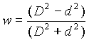
In the above, d
is the distance (in grid increments) of the neighboring point to the smoothing
point, and D is the radius of
influence [in grid increments, given by (n – 300)].
If n is between
401 and 499, then the smoothing is similar for n = 301-399, except the weighting function is the
circular aperture diffraction function (following a suggestion of Barnes et al.
1996):
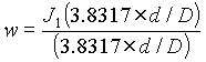
If n is between
501 and 599, then the smoothing is similar for n = 301-399, except the weighting function is the
product of the rectangular aperture diffraction function in the x and y
directions (the function used in Barnes et al. 1996):
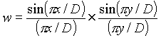
sndg: Print
sounding parameters.
Expects no values (logical); default is .false.; type is F.
Purpose: This flag causes a variety of sounding
parameters to be calculated and printed out in the lower left corner of a
skew-T sounding. It must be used with ptyp=sv! It will not work with ptyp=sc! Also, if a skew-T background is drawn on a sounding for which sndg was used with a sounding vector (ptyp=sv) plot, sndg should also be used on the plot specification line for the sounding
background, so that RIP will omit drawing skew-T background lines in the same
area as that where the sounding parameters are printed.
strm: Storm
velocity
Expects 1 or 2 real values; default is 0.0; type is F.
Purpose: The storm velocity is used to plot
storm-relative wind vectors, speeds, or trajectories. The storm velocity can be
specified in 2 ways. The first way is as a speed which is assumed to be in the
along-cross-section (left to right) direction, where the cross section position
is defined by the keywords crsa and crsb. (See descriptions of keywords crsa and crsb.)
The second way is by giving two values for strm, separated by a comma, which are the x and y
components of the storm velocity. In either case, the x and/or y
components of the storm motion will be subtracted from the x and/or y
components of the wind prior to plotting. This keyword only effects the
following fields: uuu, vvv,
ugeo, vgeo, xptgeo, xntgeo, bvfsq, spsq, wsp, wspk, wdir, xnt, amt, and xpt;
and the five trajectory fields arrow,
ribbon, swarm, gridswarm. and circle,
titl: Plot title
Expects 1 character string; default is that RIP
automatically generates the tile for each plot overlay; type is F.
Purpose: Normally, RIP automatically generates a title
for each plot overlay at the top of the frame underneath the frame title. You
can specify your own title for a plot overlay using titl. Because blank characters are not recognized in the
plot specification table, you must use the underscore character to indicate
that you want a blank character at a particular position in your specified plot
title. titl also has another
special use: it can be used to print any message at any location on the plot by
using it in conjunction with feld=bull, and it can be used to place a label above a vertical bar (feld=vbar).
time: Time
discriminator
Expects an arbitrary number of real values; default is
all times in the ptimes (or iptimes) array; type is F.
Purpose: This is a special keyword that should only
appear by itself in a PSL. It does not apply to a single plot, but rather to
the entire FSG that it is in. If you want a particular frame to be plotted only
at some of the times specified in the ptimes (or iptimes) array in
the namelist, then you can include the following line in the FSG for that
frame:
time=time1,time2,time3,...
where each of time1,
time2, time3, etc., are times, specified as real numbers. Like
the values given for the ptimes
(or iptimes) array in the
namelist, the values of time should be in hours, but do not need to be whole
numbers. If a time= PSL is
included in the FSG, then RIP will only draw that frame for those model output
times that are within tacc
seconds of one of the times in the ptimes (or iptimes) array AND
are within tacc seconds of one of
the times in the time= setting.
tjar: Arrow
widths for trajectory plots
Expects 1 or 2 real values; defaults are .003 and .035;
type is F.
Purpose: arrow
and ribbon trajectories in
horizontal plots use variable-width arrowheads, where the width of the
arrowhead indicates the height of the trajectory. The two values of tjar specify the widths (as a fraction of the total
screen width) that correspond to the lowest and highest (height-wise) values,
respectively, of the vertical window, as specified by vwin. For the feld=circle trajectories, only one value is expected for tjar, and it represents the radius of a circle corresponding
to the reference net ascent specified by vwin. For trajectories in a cross section (vertical
trajectory plots), there is no variable width feature, so only one value is
expected for tjar; if no value is
specified, .035 is the default.
tjen: End time
(in forecast hour) of plotted trajectories.
Expects 1 real value; default is the final time of the
calculated trajectory; type is F.
Purpose: This specifies the last time (i.e. the time
corresponding to the head) of the plotted trajectory. For feld=circle trajectories, this specifies the end time for the
period during which net ascent is calculated. Note that tjen may be less than or equal to the actual end time of
the calculated trajectory.
tjfl: File name
of trajectory position info.
Expects 1 character value; default is junk (i.e. a useless value); type is F.
Purpose: This specifies the name of the file containing
trajectory position information for the trajectories you want to plot. This
file should already exit, since it should have already been created by a
previous RIP run in trajectory calculation mode.
tjid: ID numbers
of trajectories to be plotted.
Expects an arbitrary number of real values; default is a
single value of 1.0; type is F.
Purpose: This specifies the ID numbers of the desired
trajectories. For the trajectory fields arrow, ribbon, swarm, or circle, all desired trajectory IDs can be listed, or IDs can be requested in
a manner similar to the way the levs
keyword is set for requesting vertical levels. See the description of the
keyword levs for more details.
For example, a setting of
tjid=1,3,8,9,-27,6,32;
would result in the plotting of trajectory numbers
1,3,8,9,15,21,27, and 32. For a trajectory swarm, the desired sequence of trajectory IDs for the swarm curve should be
specified in the order desired, and if a closed polygon is desired, the first
and last ID requested should be the same. For a trajectory gridswarm, it is assumed that part or all of the trajectories
in the position file were initially arranged in a row-oriented 2-D array. In
this case, instead of individually specifying each trajectory in the swarm
sequence (as is done for feld=swarm),
three values must be provided for the tjid keyword: (1) the ID number of the first trajectory of the gridswarm;
(2) the number of columns in the gridswarm array (i.e., the direction that
varies first); and (3) the number of rows in the gridswarm array (i.e., the
direction that varies second).
tjsp: Storm
position for storm-relative trajectories.
Expects an arbitrary number of real values, in sets of
three; default is such that this keyword is not set to anything, disabling its
effect; type is F.
Purpose: Trajectories can be plotted in a storm-relative
sense. In order to do this, RIP needs to know where the storm is. This information
is provided through either the tjsp
keyword or the strm keyword. If
the storm motion can be approximated by a constant speed and direction, then
using the strm keyword is
easiest. See the explanation of keyword strm. If the storm motion is more complicated, then tjsp must be used. Each set of three values is a time (in
model forecast hours), an x
value, and a y value. Use as many
sets as you need to cover the period of interest and to sufficiently resolve
the storm motion. RIP linearly interpolates in time and space to get the storm
position between the provided times. An IMPORTANT rule is that the x and y
values must be relative to the coarsest domain grid (the domain which is
centered on the central lat. and lon.). This is to accommodate the possibility
that the data set you are working with is from a moving nest. When
storm-relative trajectories are plotted (by either method) against other fields
or a map background, the only point along the trajectory that is actually where
it appears to be (relative to those other fields) is the point that corresponds
to the time being plotted. If tjsp
is used, RIP marks the storm position at the time being plotted with an
"L", although this feature can be disabled with the keyword nohl.
tjst: Start time
(in forecast hour) of plotted trajectories.
Expects 1 real value; default is the beginning time of
the calculated trajectory; type is F.
Purpose: This specifies the first time (i.e. the time
corresponding to the tail) of the plotted trajectory. For feld=circle trajectories, this specifies the beginning time for
the period during which net ascent is calculated. Note that tjst may be greater than or equal to the actual start
time of the calculated trajectory.
tjti: Time
interval for plotted trajectories, in hours.
Expects 1 real value; default is 1 hour; type is F.
Purpose: This specifies the time interval between arrow
heads for arrow or ribbon trajectories, or between swarms for swarm or
gridswarm trajectories. Note that this is typically greater than the time step
used to calculate the trajectories.
tshl: Text size
for high/low labels.
Expects 1 real value; default is the value of tslb; type is F.
Purpose: In contour plots, this sets the text size for
high/low labels, if it is to be different from tslb. For trajectories, this sets the text size of the
"L" marking the storm position for storm-relative trajectories.
tslb: Text size
for labels
Expects 1 real value; default is .01; type is F.
Purpose: This sets the text size (i.e. character width)
for labels, as a fraction of the width of the full plotting screen. It applies
to contour labels, lat/lon labels (in maps), perimeter tick mark labels, and
trajectory labels. It also sets the size of the bullet (or text) drawn when feld=bullet, and it sets the size of the label for feld=vbar.
tynt: Typhoon
track symbol interval (hours)
Used with feld=track. Default is every forecast output
time. A typhoon symbol (and label) is plotted every tynt hours. Increasing tynt
may improve legibility. tynt does not
affect the track printout.
v5nm: Variable
name for Vis5D
Expects 1 character string; default is whatever was
specified for feld; type is F.
Purpose: In Vis5D data set preparation mode (i.e., if imakev5d=1 in the &userin namelist), RIP assigns to each requested variable a
name that will identify that variable when Vis5D is run. For the velocity
fields, the Vis5D names are always U,
V, and W. For all other variables, the name is the same as
what was requested with the feld
keyword. However, in some cases, you may want to assign a different name. Use v5nm to do this. This keyword should only be used when
RIP is run in Vis5D data set preparation mode.
vcmx: Maximum
vector value
Expects 1 real value; default is 0.; type is F.
Purpose: This specifies the magnitude of a vector that
exactly reaches the tail of the next adjacent vector. It should be specified in
the same units as those of the vector component fields, typically m s-1.
If vcmx is set to zero, then RIP will
choose the maximum vector magnitude in the data as the magnitude of a vector
that reaches the tail of the next adjacent vector.
Special instructions for different plot types:
ptyp=hv or vw: If vcmx
is specified as any negative number, then the vectors will be plotted with the
barb/flag convention.
ptyp=sv: these
vectors can only be plotted with the barb/flag convention, so vcmx is irrelevant.
ptyp=vv: the
"next adjacent vector" means the next adjacent vector in the
horizontal direction, and vcmx
should be specified in units of the horizontal components, which will probably
be different from the units of the vertical component. Some experimentation may
be required to get a feel for this keyword in vertical vector mode. These
vectors can only be plotted as arrows, not as wind barbs, because the units in
the horizontal and vertical directions are different.
vcor: Vertical
coordinate
Expects 1 character value of length 1; default is s;
type is R.
Purpose: This defines the vertical coordinate to be used
for (1) determining plotting levels in horizontal plots; or (2) defining the
vertical axis in cross section plots; or (3) defining the variable width
feature of arrow, ribbon or circle
trajectories drawn in horizontal plots. The
possible choices for the different types of plots are:
Horizontal plots or trajectory initial points:
s: model
vertical level (k) index
p: pressure
z: height
t: potential temperature
e: equivalent potential
temperature
m: temperature
q: potential vorticity
Vertical cross sections (excluding ptyp=vv) or horizontal trajectory plots:
s: model
vertical level index
p: pressure
x: Exner function (as in
pseudoadiabatic charts)
l: log pressure
z: height
t: potential temperature
e: equivalent potential
temperature
m: temperature
q: potential vorticity
Vectors in the plane of a cross section (ptyp=vv):
s: model
vertical level index
p: pressure
z: height
(These are the only choices for ptyp=vv because they are the only vertical coordinates for
which RIP can calculate an appropriate vertical velocity).
vvms: Minimum
pressure difference between plotted vectors for cross sections and soundings
Expects 1 real value; default is 0.0; type is F.
Purpose: This specifies the minimum pressure increment
between two vectors in a column._ Due to the fact that the data are not
interpolated to a regular grid in the vertical, the vectors can become crowded
in the high-resolution PBL. If this keyword is set to some non-zero value, for
example 30, then RIP will not plot a vector if it is less than 30 hPa away from
the vector below it.
vvnx: Number of
vectors in the x-direction
Expects 1 integer value; default is 20; type is F.
Purpose: This specifies an approximate number of vectors
that are desired in the horizontal direction. It is approximate because of the
way RIP sets up the cross section grid.
vwin: Vertical
window.
Expects 1 or 2 real values; default is as shown below;
type is R.
Purpose: This determines the vertical window to use for
cross sections, or for the variable width feature of trajectory arrows,
ribbons, or circles in a horizontal plot. The first value is the bottom of the
window, and the second is the top. For trajectory circles, only one value is
specified, and this determines the reference vertical displacement amount that
corresponds to a circle of diameter set by tjar. The units of the given values are assumed to be as follows:
|
vcor |
Units |
Default values for vertical cross sections |
|
's' |
Dimensionless |
1.0, 0.0 |
|
'p','l', or 'x' |
Mb |
1050, 100 |
|
'z' |
Km |
0.0, 15.0 |
|
't' or 'e' |
K |
260, 400 |
|
'm' |
_C |
-60, 40 |
|
'q' |
PVU |
-0.5, +5.5 |
For horizontal trajectory plots, the default values
are the minimum and maximum values of the trajectories being plotted during the
time interval set by tjst and tjen. For feld=circle trajectory plots, only one value of vwin is expected, and it specifies the net ascent that
corresponds to the circle radius specified by tjar; if no value is specified, the maximum absolute net
ascent for all the trajectories requested is the default value.
wdbr: XXXXX
Distance between label bar and plot for filled contour plots
Expects 1 real value; default is -1; type is F.
Purpose: For color-filled contour plots, RIP creates a
label bar which shows what values correspond to what colors. wdbr sets the width of the area used for the label bar
(including labels), as a fraction of the total width of the screen. The default
value of -1 tells RIP to try to optimize the width. This is usually sufficient
for typical plots, i.e. it is large enough to allow room for tick labels and
lat/lon labels. However, in some cases, you may want to change this width, if
various messages or labels from other plots are being covered up by the label
bar.
xavg:
cross-section averaging distance
Expects 1 integer value; default is 0; type is F.
Purpose: Rather than plotting the value of a variable at
a point on the cross section, you may want to plot an average along a line that
extends into and out of the cross section. This may be useful for getting the
average sense of quasi-2D features such as fronts or squall lines. The
averaging distance into and out of the cross section is given by xavg in units of grid points. Hence, if the grid space is
40 km, and xavg is specified as
2, each point plotted on the cross section would represent an average from 80
km out of the cross section to 80 km into the cross section, or a total of 160
km.
xwin: Plotting
window in the x direction
Expects 2 integer values; defaults are 1, mjx (mjx
is the number of dot points in the x
(or j) direction); type is
R.
Purpose: This sets the left and right limits of the
desired subdomain for a horizontal plot, specified as grid point values on the
dot-point domain. If the first value given is outside the range 1 to mjx, it is changed to 1. If the second value given is
outside the range 1 to mjx, it is
changed to mjx. This can also be
used to save a reduced-size domain when creating a Vis5D data set (imakev5d=1), in which case it should be specified only once,
with the first requested variable.
ywin: Plotting
window in the y direction
Expects 2 integer values; defaults are 1, miy (miy is
the number of dot points in the y
(or i) direction); type is
R.
Purpose: This sets the bottom and top limits of the
desired subdomain for a horizontal plot, specified as grid point values on the
dot-point domain. If the first value given is outside the range
1 to miy, it is changed to 1. If the
second value given is outside the range 1 to miy, it is changed to miy. This can also be used to save a reduced-size domain
when creating a Vis5D data set (imakev5d=1), in which case it should be specified only once, with the first
requested variable.
Appendix B. Available fields for
plotting
This appendix is a list of all fields
that are currently available to be plotted in RIP, i.e. the names that can be
used for the feld keyword. For each
field, the name is given, the field is described, the units are given, and the
dimensionality of the field (2D or 3D) is given. Capital letters in the field
name indicate a variable character for which there is more than one choice.
a. Background fields (units and dimensionality are
irrelevant):
map: Map
background.
This field results in a map background being drawn in
the frame. Works only if ptyp=hb.
box: Box.
This field results in a box being drawn in the frame,
the size and location of which is determined by the keywords crsa and crsb.
Works only if ptyp=hb.
line: Line.
This field results in a line being drawn in the frame,
the size and location of which is determined by the keywords crsa and crsb.
Works only if ptyp=hb.
bullet: Bullet.
This field results in the drawing of a bullet (i.e., a
solid circle), the location of which is determined by the keyword crsa. It can also be used to write any text string on the
plot at the location specified by crsa. This is accomplished by setting the titl keyword equal to the desired text string. Use the
underscore character to represent blank characters in the text string. Works
only if ptyp=hb.
sids: Station
IDs.
This field results in the labeling of a station or
stations on the plot. Use the sids
keyword in conjunction with feld=sids to list the station(s) you want to be shown on the plot. See the
description of sids in Appendix A for more information. Works only if ptyp=hb.
tic: Tick mark
background.
This field results in the drawing of helpful markings on
the plot. It works in conjunction with the following ptyp settings:
ptyp=hb: The
perimeter is marked on all four sides with tick marks and labels denoting grid
points.
ptyp=vb: The left and right
perimeters are marked with tick marks and labels denoting vertical coordinate
increments. The bottom and top perimeters are marked with tick marks and labels
denoting distance along the cross section.
ptyp=sb: A standard skew-T grid
is drawn and labeled, including pressure levels, temperature contours,
adiabats, pseudoadiabats, and mixing ratio contours.
vbar: Vertical
bar.
This field results in the drawing of a vertical bar in a
vertical cross section. The location of the vertical bar is specified with the sloc keyword, and it is drawn where that location
projects perpendicularly onto the plane of the vertical cross section defined
by the current setting of crsa
and crsb. A label can be placed
above the vertical bar by using the keyword titl._ Works only if ptyp=vb.
b. Model output and diagnostic fields (listed in
alphabetical order):
amt: Absolute
momentum, m s-1. (3D)
Absolute momentum is defined here as the horizontal
wind component normal to, and out of, the cross section (as defined by the crsa and crsb
keywords) minus f (at the middle
of the cross section), all times the left-to-right distance along the
cross-section.
amtg: Geostrophic
absolute momentum, m s-1. (3D)
Same as amt, but
using geostrophic wind instead of the actual wind.
arrow: Trajectory
arrows (see Chapter 6 for more details).
avo: Absolute
vorticity (vertical component), 10-5 s-1. (3D)
bocX: Surface
precipitation type probability, percent. (2D)
The precipitation type probability is calculated
according to the REEP method of Bocchieri (1980). It uses the sounding of
temperature and wet bulb temperature to determine the probabilities. Replace X with l
for probability of liquid precipitation, f for probability of freezing precipitation, or i for probability of ice (or frozen) precipitation.
bshXU: Horizontal
bulk wind shear with variable units depending on the value of U. (2D)
The bulk wind shear is defined between the surface and
up to 9 km (X = 1 through 9). If X is not specified, it defaults to shear between the
surface and 6 km. Units of bsh
can be m s-1 (e.g. bsh5),
or knots (e.g. bsh5k).
bvfsqP: Dry
Brunt-Vaisala frequency, s-2. (3D)
brnshr: Bulk
Richardson number shear as in Stensrud et al. (1997), m2s-2.
(2D)
bvfsqP: Dry
Brunt-Vaisala frequency, s-1. (3D)
P determines
the inclusion of moist physics in the calculation of the B-V frequency: d for dry, l for liquid-only latent heating/cooling considerations, and i for liquid and ice latent heating/cooling
considerations.
cap3: Convective
available potential energy (CAPE) of parcels at all 3D grid points, J kg-1.
(3D)
In this diagnostic field, CAPE is calculated for every
grid point in the entire 3D domain, based on the lifting of a parcel starting
from that grid point. It is defined as the accumulated buoyant energy from the
LFC to the equilibrium level. To get CAPE as a 2D field, showing CAPE only from
the parcel in each column with maximum qe
below 3000 m AGL, use mcap.
cat: Clear-air
turbulence index, s-2. (3D)
This index is based on Ellrod and Knapp (1992, W&F, March issue).
cin3: Convective
inhibition (CI) of parcels at all 3D grid points, J kg-1. (3D)
In this diagnostic field, CI is calculated for every
grid point in the entire 3D domain, based on the lifting of a parcel starting
from that grid point. It is defined as the accumulated negative buoyant energy
from the parcel starting point to the LFC. To get CI as a 2D field, showing CI
only from the parcel in each column with maximum qe
below 3000 m AGL, use mcin.
circle: Net
ascent circles (a type of trajectory representation, see Chapter
6 for more details).
clgX: Cloud
ceiling, m. (2D)
Regardless of whether or not mixed phase
microphysics were used, there are three possibilities to choose from for the
determination of the phase of cloud and precipitation hydrometeors: Replace X with d
for the 0 _Celsius assumption, b for the Bocchieri assumption, or r for the mixed phase assumption. See code for details
of these assumptions.
condheat, condheati:
Diagnosed condensational heating, K h-1. (3D)
condheat
calculates the heating due to condensation in regions of explicitly resolved
saturated ascent. condheati does
the same, except it adds in the latent heat of fusion in regions that are below
freezing.
cor: Coriolis
factor, s-1. (2D)
ctt: Cloud-top
temperature, _C. (2D)
Note: cloud-top temperature is calculated by
interpolating the temperature to the level of unit optical depth into the cloud
(starting at the model top). Expressions for absorption cross-section for cloud
ice and cloud water are obtained from Dudhia (1989).
dbzXXXY: Simulated
equivalent radar reflectivity factor, dBZ. (3D)
This field calculates a simulated equivalent radar reflectivity factor, based on the mixing ratios of rain, snow, and graupel (if available). The formulas that relate mixing ratios of rain, snow, and graupel to reflectivity factor were derived assuming spherical particles of constant density, with exponential size distributions (consistent with what is used in MM5's Reisner-2 bulk microphysical scheme). If X is set to "0" (or omitted), then the simulated reflectivity is calculated using constant values of the intercept parameters for the size distributions of rain, snow, and graupel, as in early versions of Reisner-2 (this is equivalent to the field dbzc used in older RIP4 versions). If X is set to "1", then variable intercepts are used, as in more recent versions of Reisner-2 (this is equivalent to the field dbzv used in older RIP4 versions). IF Y is set to “1” (0 is default), frozen particles that are at a temperature above freezing are assumed to scatter as a liquid particle. See comments in routine "dbzcalc.f" for more details
div: Divergence
(of horizontal wind), s-1. (3D)
dmap: Map factor
on dot points, dimensionless. (2D)
dpbhAAABBB:
Pressure difference between height levels, hPa. (2D)
This field is similar to thickness, except it is
the pressure difference between height surfaces, rather than the height
difference between pressure surfaces. The two height levels are specified as
three-digit integers in units of hectometers (hm). For example, feld=dpbh015120 would give the pressure at 1.5 km AMSL minus the
pressure at 12.0 km AMSL.
dthtedz:
Convective (or potential) instability, expressed as the partial derivative of qe with respect to height, K km-1.
(3D)
ehi: Energy-helicity
index, dimensionless. (3D)
eth: Equivalent
potential temperature, K. (3D)
ethmx: Maximum
value of equivalent potential temperature below 3000 m AGL, K. (2D)
extXY: Surface
extinction coefficient due to hydrometeors, km-1. (2D)
Regardless of whether or not mixed phase
microphysics were used, there are three possibilities to choose from for the
determination of the phase of cloud and precipitation hydrometeors: Replace X with d
for the 0 _Celsius assumption, b for the Bocchieri assumption, or r for the mixed phase assumption. See code for details
of these assumptions. The extinction coefficient is calculated for only one of
the four hydrometeor types at a time: Replace Y with c
for extinction due to cloud water, r
for extinction due to rain, i for
extinction due to cloud ice, or s
for extinction due to snow.
fregWX: Flight
regulation. (2D)
This field will assign a number from 1 to 4 to each grid
point. It should therefore be plotted with the setting of ptyp=hh. The numbers correspond to the following flight
regulation categories:
1: Visual Flight Regulation (VFR)
2: Marginal Visual Flight Regulation (MVFR)
3: Instrument Flight Regulation (IFR)
4: Low Instrument Flight Regulation (LIFR)
It can be calculated based on model-diagnosed ceiling,
visibility, or both. Replace W with c for ceiling only, v for visibility only, or b for both.
Regardless of whether or not mixed phase microphysics
were used, there are three possibilities to choose from for the determination
of the phase of cloud and precipitation hydrometeors: Replace X with d for the 0 _Celsius assumption, b
for the Bocchieri assumption, or r
for the mixed phase assumption. See code for details of these assumptions.
frgmXXX:
Frontogenesis, Miller form, K (100 km h)-1. (3D)
The Miller form of frontogenesis is the Lagrangian time
rate of change of the absolute value of the horizontal gradient of potential
temperature. XXX specifies which term on
the RHS of the Miller frontogenesis equation is desired:
div: divergence
term
def: deformation term
dia: diabatic term
til: titling term
The diabatic term uses a diagnosis of condensational
heating assuming maintenance of 100% RH with respect to liquid water in regions
of explicitly resolved saturated ascent. It does not include evaporative, sublimational,
or melt cooling; fusional or depositional heating; or any diabatic results of
either the cumulus or PBL parameterization schemes.
You can also request the horizontal or vertical
advective terms (i.e., the advection of the absolute value of the horizontal
gradient of potential temperature) by specifying XXX as either had or vad.
frg2dXXX:
Frontogenesis, 2D frontal zone form, K (100 km h)-1. (3D)
The 2D form of frontogenesis examines the Lagrangian
time rate of change of the along-cross-section component of the horizontal
gradient of potential temperature. Regardless of whether you want to display
the result in a cross section or in a horizontal plot, use crsa and crsb
to define the endpoints of a cross section (and, thus, the along-cross-section
direction). XXX specifies which
term on the RHS of the uni-directional frontogenesis equation is desired:
cnf: confluence
term
shr: shear term
dia: diabatic term
til: titling term
The diabatic term uses a diagnosis of condensational
heating assuming maintenance of 100% RH with respect to liquid water in regions
of explicitly resolved saturated ascent. It does not include evaporative,
sublimational, or melt cooling; fusional or depositional heating; or any
diabatic results of either the cumulus or PBL parameterization schemes.
You can also request the advective terms (i.e., the
advection of the along-cross-section component of the horizontal gradient of
potential temperature) by specifying XXX
as either aad, iad, or or vad. These refer to the advection along the cross section, the advection
into the cross section, and the vertical advection, respectively. For the two
horizontal advective terms, you can specify a wind speed and direction with the
strm keyword so that relative
winds will be used in the advective calculation.
Finally, all of the fields that are used to calculate
the above terms can be smoothed on constant-pressure surfaces prior to the
computing of products in the nonlinear terms, by using the qgsm keyword.
ght: Geopotential
height above mean sea level, m. (3D)
ghtagl:
Geopotential height above ground level, m. (3D)
gridswarm:
Trajectory gridswarm (see Chapter 6 for more details).
intcld:
Column-integrated cloud hydrometeors, mm. (2D)
This is the column-integrated value of the field qcl (i.e., the sum of the fields qcl and qci).
intclq:
Column-integrated cloud liquid water, mm. (2D)
This is the column-integrated value of the field qcw.
intpcp:
Column-integrated precipitation mass, mm. (2D)
This is the column-integrated value of the field qpr (i.e., the sum of the fields qra, qsn,
and qgr).
k-index: k-index of the grid points, dimensionless. (3D)
This field can be used to show where the model levels
are in a vertical cross section, or in a horizontal plot interpolated to an
alternate vertical coordinate.
lcl: Lifted
condensation level (LCL), m (AGL). (2D)
This is the LCL for the parcel in each column with
maximum qe below 3000 m AGL.
lfc: Level of
free convection (LFC), m (AGL). (2D)
This is the LFC for the parcel in each column with
maximum qe below 3000 m AGL.
maxdbzX: Maximum
simulated equivalent radar reflectivity factor in a column, dBZ. (2D)
The definition of simulated equivalent radar
reflectivity factor and X are the same
as for dbzX.
mcap: Maximum
convective available potential energy (MCAPE), J kg-1. (2D)
This is the CAPE for the parcel in each column with
maximum qe below 3000 m AGL.
mcin: Convective
inhibition (CI) for MCAPE parcel, J kg-1. (2D)
This is the CI for the parcel in each column with
maximum qe below 3000 m AGL.
omg: Omega (dp/dt), m
bar s-1. (3D)
pcptw:
Precipitable total water, mm. (2D)
This is the column-integrated total water (vapor plus
all hydrometeors).
pcpwv:
Precipitable water vapor, mm. (2D)
This is the column-integrated water vapor only.
phydpNN:
Hydrostatic pressure perturbation, mb. (3D)
This is the same as ppt (below), except it is the perturbation of the
hydrostatic pressure (not the total pressure) with respect to the reference
state, as defined by the keyword rfst. A model vertical level must be chosen at which hydrostatic pressure
is defined to be equal to full pressure. This level is specified as a k-index with NN
ppt: Pressure
perturbation, mb. (3D)
The perturbation is with respect to the reference state,
as defined by the keyword rfst.
prs: Pressure,
mb. (3D)
pvm: Moist
potential vorticity (hydrostatic form), PVU. (3D)
pvo: Potential
vorticity (hydrostatic form), PVU. (3D)
qci: Cloud ice
mixing ratio, g kg-1. (3D)
Note: If non-mixed-phase microphysics was used,
this field contains the model output cloud water only where T < 0 _C,
and is zero where T > 0 _C.
qcl: Total cloud
mixing ratio, g kg-1. (3D)
Note: This is just qcw + qci.
qcw: Cloud water
mixing ratio, g kg-1. (3D)
Note: If non-mixed-phase microphysics was used, this
field contains the model output cloud water where T > 0 _C,
and is zero where T < 0 _C.
qgomfNNN: Full
omega (subjected to same processing as QG omega), m bar s-1. (3D)
This field is, in principle, the same as feld=omg, except it subjects the full omega (i.e., dp/dt)
field to the same processing as the input fields to QG omega, thus allowing for
a meaningful comparison between full omega and QG omega. The actions that qgomf are subjected to are an interpolation to a
pressure-level grid, a smoothing on that grid (as determined by the value of
the keyword qgsm---see the
explanation for qgomg below and
the explanation for qgsm in Appendix A), and an interpolation back to the model vertical
levels.
qgomgNNN or qmomgNNNRR: Quasi-geostrophic omega, m bar s-1. (3D)
This field is calculated by means of a 3-D inversion
(using over-relaxation) of the Q-vector
form of the quasigeostrophic omega equation, using the domain average Coriolis
parameter and vertical stability profile. It is performed on a pressure-level
grid, with an irregular lower boundary that matches (as closely as possible)
the model topography. The lower boundary condition includes both a topographic
BC and an Ekman BC. The three N’s
correspond to the Q-vector
forcing, the topographic boundary condition, and the Ekman boundary condition,
respectively. Each of the N’s should be replaced with either a 1 or 0, to
indicate that the corresponding forcing is included or excluded in the omega
equation inversion. For example, feld=qgomg101 would request QG omega calculated from the Q-vector forcing, including the Ekman boundary
condition but not the topographic boundary condition. The difference between ‘qg’ and ‘qm’
is that in the former case, the dry static stability is used everywhere,
whereas in the latter case, the moist static stability is used where the
relative humidity exceeds a threshold value. The threshold value is specified
by replacing ‘RR’ with a two
digit percent value ranging from 00 to 99.
Note: The first step that RIP takes in calculating this
field is the interpolation of geopotential height and specific volume to
pressure levels. Following that step, but prior to calculating the Q-vector, it is likely that you'll want to have those
fields smoothed, so that they represent synoptic or meso-alpha scales. This
cannot be accomplished by using smth
or smcp, because the smoothing
must occur prior to the Q-vector
calculation. A special capability has been set up to do this intermediate
smoothing. It is accomplished by setting the value of the keyword qgsm to a value that indicates the desired number of
smoothing passes, as described for the keyword smth. So, for example, if you want the intermediate
pressure-level fields to be smoothed with 4 passes of the smoother-desmoother,
then use qgsm=104.
qgr: Graupel
mixing ratio (if available as a separate RIP data file), g kg-1.
(3D)
qpr: Total
precipitation hydrometeor mixing ratio, g kg-1. (3D)
Note: This is just qra + qsn (+
qgr if available).
qra: Rain water
mixing ratio, g kg-1. (3D)
Note: If non-mixed-phase microphysics was used, this
field contains the model output rain water only where T > 0 _C.,
and is zero where T < 0 _C.
qsn: Snow mixing
ratio, g kg-1. (3D)
Note: If non-mixed-phase microphysics was used, this
field contains the model output rain water only where T < 0 _C,
and is zero where T > 0 _C.
qvdiv: Divergence
of the Q-vector, 10-12 s-3 mb-1. (3D)
Note: See the note on intermediate smoothing under the
description of the field qgomg, above.
qvp: Water vapor
mixing ratio, g kg-1. (3D)
qvx: x-component of the Q-vector, 10-6 m s-3 mb-1.
(3D)
Note: See the note on intermediate smoothing under
the description of the field qgomg,
above.
qvy: y-component of the Q-vector, 10-6 m s-3 mb-1.
(3D)
Note: See the note on intermediate smoothing under the
description of the field qgomg, above.
rSSST:
Accumulated rainfall (or more generally, precipitation), mm. (2D)
SSS determines
the source of the precipitation you're interested in: cum for cumulus parameterization precipitation, exp for explicitly resolved precipitation, and tot for the sum of cumulus and explicit. T (which will actually be two or more characters in
length) determines the desired accumulation time period. If it is of the form Nh, where N
is a time period in hours specified either as an integer or as a real number,
then RIP will interpret this as "in the past N hours". If it is of the form shN, then RIP will interpret this as "since hour N". An important consideration is that the time
that is implied by the specification of T must be available in your RIP data set, or else RIP will not be able
to access the precipitation file(s) at that time to perform the subtraction. If
the time implied by T is negative
(for example, if you're trying to plot 6-h precipitation accumulation at
forecast hour 3), RIP will use the hour-0 data for the subtraction. Here are
some examples:
feld=rcum3h
-> gives cumulus precip in past 3 h
feld=rtotsh0 -> gives total
(cumulus + explicit) precip since hour 0
feld=rexpsh12.5 -> gives
explicit precip since hour 12.5
feld=rtot24h -> gives total
(cumulus + explicit) in past 24 h; but if plotted before hour 24, gives total
precip since hour 0
rhi: Relative
humidity with respect to ice, percent. (3D)
rho: Density, kg
m-3. (3D)
rhu: Relative
humidity with respect to liquid water, percent. (3D)
rib: Near-surface
Richardson number, as used in high-resolution PBL scheme, s-2. (2D)
ribbon:
Trajectory ribbons (see Chapter 6 for more details).
richnPSSS:
Richardson number, dimensionless number. (3D)
P determines
the inclusion of moist physics in the calculation of the B-V frequency: d for dry, l for liquid-only latent heating/cooling considerations, and i for liquid and ice latent heating/cooling considerations.
SSS determines the number of
horizontal smoothing passes (on model vertical levels) for the velocity prior
to calculation of Rich. num. The SSS
value can be omitted if no smoothing is desired, i.e. feld=richnd000 is the same as feld=richnd. For an explanation of the smoothing routine, see
the description of the keyword smth
in Appendix A. The component of the wind used for the shear
calculation is the along-cross-section (left-to-right) component, where the
cross section endpoints are determined by the crsa and crsb
keywords.
sateth:
Saturation equivalent potential temperature, K. (3D)
This is the value of equivalent potential
temperature a parcel would have if it were brought to saturation without change
in temperature or pressure.
sdpU: Surface
dewpoint temperature, units determined by U. (3D)
This field is intended to represent the surface dewpoint
temperature as measured by a surface meteorological station (at ~10 m height
AGL). From terrain-following data sets, it is calculated with surface pressure,
and water vapor mixing ratio at the lowest model level._ From pressure- or
height-level output, it is calculated from surface pressure, and from a surface
water vapor analysis that RIP looks for in a file ending in tmk_sfan._ Units can be either in Celsius, Kelvin, or
Fahrenheit, depending on whether U
is set to c, k, or f.
seFFFNNNNN or smFFFNNNNN: Various fields derived from inversion of the
Sawyer-Eliassen equation, units are variable. (3D)
FFF is either psi (Sawyer-Eliassen streamfunction, mb m s-1),
vab (balanced ageostrophic wind
in the plane of the cross section, m s-1), vtb (geostrophic plus balanced ageostrophic wind in the
plane of the cross section, m s-1), or omb (balanced vertical velocity, m bar s-1). The five N’s correspond to five different forcings that can be
included in the inversion of the Sawyer-Eliassen equation. They are the
confluent frontogenesis term on the RHS, the shear frontogenesis term on the
RHS, a topographic boundary condition, an Ekman boundary condition, and a side
boundary condition that approximately relates the vertical derivative of y to the actual ageostrophic wind along the
sides of the cross section. Each of the N_s
should be set to 1 or 0 to indicate that the corresponding forcing is included
or excluded in the Sawyer-Eliassen inversion. The difference between ‘se’ and ‘sm’
is that in the former case, the dry static stability is used everywhere,
whereas in the latter case, the moist static stability is used where vertical
velocity is upward and the relative humidity exceeds a threshold value. The
moist version is solved "double-iteratively", that is to say, the
relaxation is carried out to convergence several times, with each of the
"big" iterations using the vertical velocity obtained from the
previous "big" iteration in order to choose between moist and dry
stability at each grid point in the cross section.
A variety of parameters can be adjusted in running the
Sawyer-Eliassen diagnosis. These are specified through the keyword sepa, which is described in detail in Appendix
A.
Note: The Sawyer-Eliassen fields can only be plotted in
a vertical cross section with pressure as the vertical coordinate.
sfp: Surface
pressure, mb. (2D)
slp: Sea-level pressure
inspired by Benjamin and Miller (1990), mb. (2D)
snf: Frozen
fraction of precipitation hydrometeor mixing ratios, dimensionless number
between 0.0 and 1.0. (3D)
Note: This is just [qsn (+ qgr if available) ] / qpr. If qpr
is less than .0001 g kg-1, then snf is set to 0.5. This can be used to give a nice
depiction of the "rain/snow line" if mixed phase microphysics are
used.
sno: Snow cover
(if available as a separate RIP data file). (2D)
spsqTPSSS: Scorer
parameter squared, m-2. (3D)
T determines
which terms to include: a for N2/(u-c)2, b for uzz/(u-c), or t
for total (a + b). P
determines the inclusion of moist physics in the calculation of the B-V
frequency: d for dry, l for liquid-only latent heating/cooling
considerations, and i for liquid
and ice latent heating/cooling considerations. SSS determines the number of horizontal smoothing passes
(on model vertical levels) for the velocity prior to calculation of Scorer
parameter. The SSS value can be
omitted if no smoothing is desired, i.e. feld=spsqtd000 is the same as feld=spsqtd. For an explanation of the smoothing routine, see
the description of the smth
keyword in Appendix A. The component of the wind used for
the shear calculation is the along-cross-section (left-to-right) component,
where the cross section endpoints are determined by the crsa and crsb
keywords. The phase speed in terms a
and b can be provided with the strm keyword. See the description of the strm keyword in Appendix A.
sr9:
Storm-relative flow at 9 km AGL, m s-1. (2D)
sreh:
Storm-relative environmental helicity, m2 s-2. (2D)
Assumes a supercell storm moves at 75% of the
magnitude of, and 30_ to the right of,
the mean wind vector between 3 and 10 km AGL.
srfh: Storm-relative
flow at high levels (~9 km), m2 s-2. (2D)
Assumes a supercell storm moves at 75% of the magnitude
of, and 30_ to the right of, the mean
wind vector between 3 and 10 km AGL.
srfl:
Storm-relative flow at low levels (~2 km), m2 s-2. (2D)
Assumes a supercell storm moves at 75% of the magnitude
of, and 30_ to the right of, the mean
wind vector between 3 and 10 km AGL.
stb: Static
stability [-dq/dp], K hPa-1. (3D)
stbe: Potential
or convective stability [-dqe/dp],
K hPa-1. (3D)
stbz: Static
stability [dq/dz], K km-1. (3D)
swarm: Trajectory
swarm (see Chapter 6 for more details).
tdd: Dew point
depression, _C. (3D)
tdf: Dew point
temperature, _F. (3D)
tdk: Dew point
temperature, K. (3D)
tdp: Dew point
temperature, _C. (3D)
tdsfU: Surface
dew point temperature, units are variable depending on the value of U. (2D)
It is computed using 2 m water vapor mixing ratio if
available. Otherwise it uses the moisture field from the lowest model level.
Units of tdsfU can be either in Celsius,
Kelvin, or Fahrenheit, depending on whether U is set to c, k, or f.
ter: Terrain
height, m. (2D)
tfp: Frost point
temperature, _C. (3D)
tgc: Ground
temperature, _C. (2D)
tgk: Ground
temperature, K. (2D)
thckMMMNNN:
Thickness, decameters (or dam). (2D)
MMM and NNN are the lower and upper pressure levels,
respectively, expressed in kPa with leading zeros included, so that the total
number of digits is always 6. For example:
thck100050
-> This gives the 1000 to 500 hPa thickness.
thck050005 -> This gives the
500 to 50 hPa thickness.
the: Potential
temperature, K. (3D)
thsf: Surface air
potential temperature, K. (2D)
This is intended to represent the surface air potential
temperature as measured by a surface meteorological station (at ~10 m height
AGL). The surface air temperature is first calculated, as described for field tsfU._ It is then converted to potential temperature.
thv: Virtual
potential temperature, K. (3D)
thvhm: Virtual
potential temperature, with hydrometeor effect included, K. (3D)
This is the same as thv, except it is virtual potential temperature
including the negative effects of hydrometeors.
tmc: Temperature,
_C. (3D)
tmclKK:
Temperature of a lifted parcel, _C.
(3D)
The level from which parcels are to be lifted is
the model level that is the KKth level
from the bottom (always use two digits). Therefore, this field is only defined
for model levels at or above that level. This field is most useful for plotting
in a sounding, to give a sense of the CAPE.
tmf: Temperature,
_F. (3D)
tmk: Temperature,
K. (3D)
tpt: Temperature
perturbation, _C (or K). (3D)
The perturbation is with respect to the reference
state, as defined by the keyword rfst.
tptslr:
Temperature perturbation with respect to the U.S. Standard Atmosphere, _C. (or K) (3D)
track: Typhoon
track
Objectively-determined typhoon track including
central pressures. The default code is able to track five storms
simultaneously. The track is plotted using all times in the .xtimes file,
regardless of the value of ptimes. The typhoon symbol and central pressure
locations are plotted based on the keyword tynt. The typhoon location, central
pressure, and maximum surface wind speed is printed out at each forecast output
time. While the track algorithm is designed for use with any model grid
spacing, performance for any particular delta-x may be improved by tuning the
algorithm. Additional documentation is included in the source code (including a
sample plspec entry).
tsfU: Surface air
temperature, units are variable depending on the value of U. (2D)
If 2 m temperature is available from the dataset,
this is that temperature. Otherwise, this temperature is intended to represent
the surface air temperature as measured by a surface meteorological station (at
~10 m height AGL). From terrain-following data sets, it is calculated with a
crude application of similarity theory: if the air temperature at the lowest
model layer (TLML) is warmer
than the ground temperature, tsfc
is equal to TLML; if TLML is colder than the ground temperature,
tsfc is equal to the average of
the ground temperature and TLML.
From pressure- or height-level output, it looks for the surface air temperature
analysis that is stored in the file ending in tmk_sfan. Units of tsfU can be either in Celsius, Kelvin, or Fahrenheit, depending on whether U is set to c, k, or f.
tvc: Virtual
temperature, _C. (3D)
tvclKK: Virtual
temperature of a lifted parcel, _C.
(3D)
This is the same as tmcl, except it gives the virtual temperature of a lifted parcel. When
plotted alongside tvc on a skew-T
sounding, this gives a more accurate graphical representation of CAPE than does
tmcl plotted alongside tmc.
tvk: Virtual
temperature, K. (3D)
tvp: Virtual
temperature perturbation, _C (or
K). (3D)
This is the same as tpt, except it is the perturbation of virtual
temperature with respect to the reference state, as defined by the keyword rfst.
tvphm: Virtual
temperature perturbation, with hydrometeor effect included, _C (or K). (3D)
This is the same as tvp, except it is the perturbation of virtual
temperature including the negative effects of hydrometeors on virtual
temperature.
twb: Wet bulb
temperature, _C. (3D)
uageo: Horizontal
ageostrophic wind speed in the x
(or j-index) direction, m s-1.
(3D)
ugeo: Horizontal
geostrophic wind speed in the x
(or j-index) direction, m s-1.
(3D)
unor: Westerly
horizontal wind component, m s-1. (3D)
uubs: 0-6 km
shear (x-component), m s-1.
(2D)
uusr: Supercell
motion vector following Bukers et al (1999) (x-component), m s-1. (2D)
uuu: Horizontal wind
speed in the x (or j-index) direction, m s-1. (3D)
vadvtheta:
Vertical advection of potential temperature, K h-1. (3D)
This calculates the local change in potential
temperature due to vertical advection. The vertical velocity and potential
temperature fields can be smoothed on constant-pressure surfaces prior to the
computing of the product in this nonlinear quantity, by using the qgsm keyword.
vageo: Horizontal
ageostrophic wind speed in the y
(or i-index) direction, m s-1.
(3D)
vgeo: Horizontal
geostrophic wind speed in the y
(or i-index) direction, m s-1.
(3D)
vgp: Vorticity
generation potential, m s-2. (2D)
This is the 0 to 3 km AGL total shear (i.e., the
length of the 0-3 km AGL hodograph divided by 3000 m) times the square root of
CAPE of the parcel with maximum qe
below 3 km AGL.
visX: Surface
visibility due to hydrometeors, km. (2D)
Regardless of whether mixed phase microphysics were
used, there are three possibilities to choose from for the determination of the
phase of cloud and precipitation hydrometeors: Replace X with d
for the 0 _Celsius assumption, b for the Bocchieri assumption, or r for the mixed phase assumption. See code for details
of these assumptions.
vnor: Southerly
horizontal wind component, m s-1. (3D)
vor: Relative
vorticity (vertical component), 10-5 s-1. (3D)
vox: x-component of vorticity, 10-5 s-1.
(3D)
voy: y-component of vorticity, 10-5 s-1.
(3D)
vvbs: 0-6 km
shear (y-component), m s-1.
(2D)
vvsr: Supercell
motion vector following Bukers et al (1999) (y-component), m s-1. (2D)
vvv: Horizontal
wind speed in the y (or i-index) direction, m s-1. (3D)
wdr: Horizontal
wind direction (compass direction that wind is blowing from), degrees. (3D)
wsp: Horizontal
wind speed, m s-1. (3D)
www: Vertical
velocity (dz/dt), cm s-1. (3D)
xlat: Latitude
(if available as a separate RIP data file). (2D)
xlon: Longitude
(if available as a separate RIP data file). (2D)
xlus: Land use
category (if available as a separate RIP data file). (2D)
xmap: Map factor,
dimensionless number. (2D)
xnt: Horizontal
wind component normal to the cross section, m s-1. (3D)
Note: The normal wind component is calculated using the
cross section end points defined by the crsa and crsb keywords.
Positive is assumed to be into the cross section.
xntageo:
Horizontal ageostrophic wind component normal to the cross section, m s-1.
(3D)
Note: The normal wind component is calculated using the
cross section end points defined by the crsa and crsb keywords.
Positive is assumed to be into the cross section.
xntgeo:
Horizontal geostrophic wind component normal to the cross section, m s-1.
(3D)
Note: The normal wind component is calculated using the
cross section end points defined by the crsa and crsb keywords.
Positive is assumed to be into the cross section.
xpt: Horizontal
wind component parallel to the cross section, m s-1. (3D)
Note: The parallel wind component is calculated using
the cross section end points defined by the crsa and crsb keywords.
Positive is assumed to be from left to right.
xptageo: Horizontal
ageostrophic wind component parallel to the cross section, m s-1.
(3D)
Note: The parallel wind component is calculated using
the cross section end points defined by the crsa and crsb keywords.
Positive is assumed to be from left to right.
xptgeo: Horizontal
geostrophic wind component parallel to the cross section, m s-1.
(3D)
Note: The parallel wind component is calculated using
the cross section end points defined by the crsa and crsb keywords.
Positive is assumed to be from left to right.
Appendix C. Format of RIP data
files
When RIPDP is executed, it produces a large number of
data files._ This appendix describes the naming convention and format of RIP
data files.
a._ The .xtimes file
A text file is created, with the name model-data-set-name.xtimes,
where model-data-set-name
is as defined in Section 3._ On the first line of the file
is the total number of times available in the RIP data set._ Beneath the first
line is a list of those times (one time per line)._ Each time is expressed as a
forecast hour with four digits left of the decimal and five to the right.
b._ The .minfo file
A text file is created, with the name model-data-set-name.minfo._
This file contains one or more lines of textual information about the model
run, which can be read in by RIP and plotted at the bottom of each plot
produced by RIP, to give the viewer some basic information about the model run.
c._ The data files
The data files are named with the following convention:
model-data-set-name _ HHHH.HHHHH _ variable
model-data-set-name
is as defined in Section 3._ HHHH.HHHHH is the forecast time in hours (four
digits left of the decimal and five to the right)._ variable is the name of the variable that is
contained in the file._ These three pieces of the file name are separated by
underscore characters.
The format of the file is perhaps best described by
showing the Fortran 77 code with which it can be written:
c
c__
Declare RIP header variables
c
_____
integer ihrip(32)
_____
real rhrip(32)
_____
character chrip(64)*64,vardesc*64,plchun*24
c
c__
Declare 3D and 2D (horizontal slab) data arrays
c
_____
real data3(maxiy,maxjx,maxkz), data2(maxiy,maxjx)
c
c__
Open the file, write header and data, close the file
c
_____
open (unit=10,file=<filename>,form=’unformatted’,status=’new’)
_____
write (10) vardesc,plchun,ihrip,rhrip,chrip
_____
write (10) data3
c_
or write (10) data2__ for a 2D field
_____
close (10)
maxiy
and maxjx are the dimensions of
the dot-point gird, regardless of whether the variable is defined on dot points
or cross points._ maxkz is the
number of vertical levels._ All 3D variables in a RIP data set must be defined
on the same vertical levels._ For example, in the MM5 vertical coordinate
system, most of the variables are defined on the staggered “half-sigma” levels,
but vertical velocity is defined on the “full-sigma” levels._ To adhere to the
“same vertical levels” requirement, ripdp_mm5 interpolates the vertical velocities to the “half-sigma” levels._ maxkz would then be equal to the
number of half-sigma levels.
vardesc
is a character string, 64 characters maximum length, that contains a brief
verbal description of the variable._ It may also include units, although the
representation of units is limited to the ASCII character set.
plchun
is a character string, 24 characters maximum length, that contains the units of
the variable, in NCAR Graphics PLOTCHAR code._ This code can be used by the
NCAR Graphics code in RIP to display the units of the variable on a plot,
including special characters (e.g., Greek symbols) and exponents.
ihrip
and rhrip are integer and real
header arrays (respectively) contain information about model dimensions, start
time and date, and map background, as well as information about the variable
such as a brief description and units._ The chrip
array contains a text description, 64 characters maximum length, of each of the
elements of the ihrip and rhrip arrays._ Elements 1-32 of chrip correspond to the 32 elements of
ihrip, and elements 33-64 of chrip correspond to the 32 elements or
rhrip._ Note that not all of the
elements of ihrip and rhrip are used._ A list of all the
currently defined elements of ihrip
and rhrip, as well as the text
description in the corresponding element of chrip,
are shown in the table below:
|
Header Array Element |
Description |
|
ihrip( 1) |
chrip( 1)='map
projection (0: none/ideal, 1: LC, 2: PS, 3: ME, 4: SRCE)' |
|
ihrip( 2) |
chrip( 2)='number
of dot points in the y-direction (coarse domain)________ ' |
|
ihrip( 3) |
chrip( 3)='number
of dot points in the x-direction (coarse domain)________ ' |
|
ihrip( 4) |
chrip( 4)='number
of dot points in the y-direction (this domain)_______ ___' |
|
ihrip( 5) |
chrip( 5)='number
of dot points in the x-direction (this domain)__________ ' |
|
ihrip( 6) |
chrip( 6)='number
of dimensions of this variable (2 or 3)_________________ ' |
|
ihrip( 7) |
chrip( 7)='grid
of this variable (1: cross point dom., 0: dot point dom.)_ ' |
|
ihrip( 9) |
chrip( 9)='number
of vertical levels in the data__________________________ ' |
|
ihrip(10) |
chrip(10)='mdateb:
YYMMDDHH (truncated hour) of hour-0 for this dataset___ ' |
|
ihrip(11) |
chrip(11)='mdate:
YYMMDDHH (truncated hour) of this time__________________ ' |
|
ihrip(12) |
chrip(12)='ice
physics (1: sep. arrays for ice fields, 0: no sep. arrays)_ ' |
|
ihrip(13) |
chrip(13)='ver.
coord. type: <or=3: hgt. or prs.; >or=4: terrain-following ' |
|
ihrip(14) |
chrip(14)='landuse
dataset (1: old, 13-cat; 2: USGS, 24-cat; 3: SiB, 16 )_ ' |
|
rhrip( 1) |
chrip(33)='first
true latitude (deg.)_____________________________________ ' |
|
rhrip( 2) |
chrip(34)='second
true latitude (deg.)____________________________________ ' |
|
rhrip( 3) |
chrip(35)='central
latitude of coarse domain (deg.)_______________________ ' |
|
rhrip( 4) |
chrip(36)='central
longitude of coarse domain(deg.)_______________________ ' |
|
rhrip( 5) |
chrip(37)='grid
distance of coarse domain (km)____________________________ ' |
|
rhrip( 6) |
chrip(38)='grid
distance of this domain (km)______________________________ ' |
|
rhrip( 7) |
chrip(39)='coarse
dom. y-position of lower left corner of this domain _____' |
|
rhrip( 8) |
chrip(40)='coarse
dom. x-position of lower left corner of this domain_____ ' |
|
rhrip(13) |
chrip(45)='rhourb:
diff (in h) between exact time and mdate of hour-0_____ ' |
|
rhrip(14) |
chrip(46)='rhour:
diff (in h) between exact time and mdate of this data___ ' |
|
rhrip(15) |
chrip(47)='xtime:
exact time of this data relative to exact hour-0 (in h)_ ' |
If you want to create a version of RIPDP that converts output from a given
model into a RIP data set, there are certain rules that apply to the variable
that RIPDP can or should create, and the variables expected by RIP._ The data
variables can be classified into three different categories:
1)
Required variables
2)
Optional variables
3)
Unexpected variables
Required variables are fundamental variables that RIP expects to find at
every time period that will be processed._ If it does not, it will abort._
Therefore, RIPDP_ should create these variables exactly as shown in the table
below, particularly in terms of variable name, dimensionality, and grid (cross
or dot-point).
Table of Required Variables
|
Variable |
Dimensions [ihrip(6)] |
Grid [ihrip(7)] |
Description of variable
(vardesc) |
Units of variable in
PLOTCHAR code (plchun) |
|
uuu |
3 |
0 |
Horizontal wind
(y-comp.), m/s |
m s~S~-1~N~ |
|
vvv |
3 |
0 |
Horizontal wind
(y-comp.), m/s |
m s~S~-1~N~ |
|
tmk |
3 |
1 |
Temperature, K |
K |
|
ght |
3 |
1 |
Geopotential
height, m |
m |
|
prs |
3 |
1 |
Pressure, hPa |
hPa |
|
ter |
2 |
1 |
Terrain height
AMSL, m |
m |
|
sfp |
2 |
1 |
Surface pressure,
hPa |
hPa |
|
xmap |
2 |
1 |
Map factor on
cross points |
none |
|
dmap |
2 |
0 |
Map factor on dot
points |
none |
|
cor |
2 |
1 |
Coriolis
parameter, per s |
s~S~-1~N~ |
Optional variables are variables that RIP might expect to find depending on
the field(s) requested in the user input file. However, they are not required
for RIP to run. If any of these variables is requested directly, or if a field
is requested that requires one of the optional variables, in some cases the
variable will be assumed to be zero, and in other cases RIP will abort. If you
are creating a version of RIPDP for your model, it is a good idea to have it
create these optional variables if they are available, and to make sure they
agree with the attributes shown in the table below. This will improve the
functionality of RIP. For example, there is a field in RIP called qpr, which is the sum of all the precipitation mixing
ratio fields. When this field is calculated, RIP specifically looks for files
with variable names qra, qsn, and qgr.
If they do not exist, or if they exist but are named something else, then the qpr field will not work.
Table of Optional Variables
|
Variable |
Dimensions [ihrip(6)] |
Grid [ihrip(7)] |
Description of variable
(vardesc) |
Units of variable in
PLOTCHAR code (plchun) |
|
qvp |
3 |
1 |
Water vapor
mixing ratio, g/kg |
g kg~S~-1~N~ |
|
www |
3 |
1 |
Vertical
velocity, cm/s |
cm s~S~-1~N~ |
|
qcw |
3 |
1 |
Cloud water
mixing ratio, g/kg |
g kg~S~-1~N~ |
|
qra |
3 |
1 |
Rain water mixing
ratio, g/kg |
g kg~S~-1~N~ |
|
qci |
3 |
1 |
Cloud ice mixing
ratio, g/kg |
g kg~S~-1~N~ |
|
qsn |
3 |
1 |
Snow mixing
ratio, g/kg |
g kg~S~-1~N~ |
|
qgr |
3 |
1 |
Graupel mixing
ratio, g/kg |
g kg~S~-1~N~ |
|
rtc |
2 |
1 |
Cumulus precip.
since h 0, mm |
Mm |
|
rte |
2 |
1 |
Explicit precip.
since h 0, mm |
Mm |
|
tgk |
2 |
1 |
Ground/sea-surface
temperature, K |
K |
|
tmk_sfan |
2 |
1 |
Temperature (sfc.
anal.), K |
K |
|
qvp_sfan |
2 |
1 |
Water vapor
mixing ratio (sfc. anal.), g/kg |
g kg~S~-1~N~ |
|
xlat |
2 |
1 |
Latitude, degrees |
degrees |
|
xlon |
2 |
1 |
Longitude,
degrees |
degrees |
|
xlus |
2 |
1 |
Land use category |
none |
Finally, an unexpected variable is a variable that RIPDP does not
specifically expect to find in the model output, but upon encountering it,
processes it and creates a data file. The variable name, dimensionality, grid,
description, and units are determined from metadata in the model output file.
These variables can be plotted by RIP by using the automatically determined
variable name in the feld= plot
specifier.