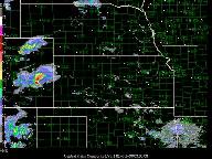
Convective clusters situated in moist easterly flow
persist throughout evening (0000 - 0600 UTC 2 July) in eastern Colorado.
These clusters merge and evolve into a well organized squall line
with stratiform precipitation over western and central Kansas overnight.
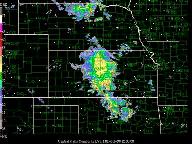
This MCS subsequently merges with an area of less organized convection
over northern Oklahoma near sunrise (around 1000-1200 UTC). An MCV
is evident in the aftermath of the decayed squall line convection
over central/eastern Kansas. Convective activity persists somewhat
longer (past sunrise) along the southern portion of the merged system.
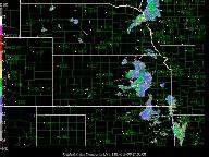
By midmorning (1500 UTC 2 July) visible satellite imagery indicates
an outflow boundary moving southeastward from an active convective
cluster in northeastern Oklahoma. This outflow becomes the focus
for an afternoon convective system over Arkansas back into southeastern
OKlahoma. This secondary MCS dissipates during the early evening
(after 0000 UTC 3 July) in the environment of weak vertical wind
shear. During the day the MCV farther to the north persists while
moving slowly eastward into Missouri. A first the MCV is relatively
inert producing only light precipitation during the afternoon and
early evening. However, a small cluster of convection that forms
around midnight near the MCV center in central Missouri (around
0400-0500 UTC 3 July) is remarkably long-lived, persisting through
the following morning as it moves southeastward into Kentucky and
Tennessee.
S.T.
Key images
Surface ict (0000 UTC 2 July)
Nexrad cent_plains (0000 UTC 2 July - 0000 UTC 3 July)
Nexrad cent_missvly (1500 UTC 2 July - 0000 UTC 4 July)
Nexrad south_plains (1500 UTC 2 July - 0400 UTC 3 July)
Sat ict (1200 UTC 2 July - 0100 UTC 3 July)
Profiler msl_wp (0000 UTC 2 July - 0000 UTC 3 July)
Profiler agl_wp (0000 UTC 2 July - 0000 UTC 3 July)
NCAR is sponsored by the National Science Foundation