Heavy rain event along the front range of the Rockies (afternoon)
and over the central Great Plains of the U.S. (overnight) within
a week-long pattern of similar occurrences. This event occurred
during an active southwest monsoon pattern with a quasi-stationary
surface front oriented east-west across the central U.S. Afternoon
convection in the monsoon pattern produces up to 6 in. of rain in
the Denver area. This convection merges with convection on the Colorado
high plains to form a large squall-type MCS with stratiform precipation
along the Colorado-Kansas border during the late evening and overnight.
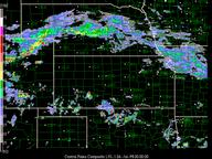
A series of short convective bands with quasi-periodic spacing that
form out ahead of the MCS in SW Kansas (0300 UTC - 0600 UTC 26 July)
could be associated with PBL wave activity. Meanwhile east-west
oriented bands of substantial longitudinal extend form over northern
and central Kansas ahead of the approaching MCS. These bands, which
form north of the surface front in a strong southerly low-level
jet environment, become the dominant convection during the predawn
hours (e.g., 0900 UTC) and produce up to 6 in of rain in the Kansas
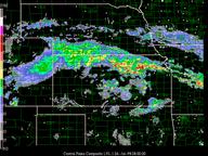
City area. The Colorado MCS that approached from the west has dissipated
leaving a short-lived MCV in its wake over NW Kansas. The large
mass of stratiform precipitation dissipates over Missouri and the
lower Ohio Valley after sunrise on 26 July. Convection redevelops
over Colorado the following afternoon and although less extensive
a similar precipitation pattern occurs over the central plains the
following night.
Key images
Composite map (0100 or 0200 UTC 26 July)
Surface map (1800 UTC 25 July - 1800 UTC 26 July)
Sat irmb (1800 UTC 25 July - 1800 UTC 26 July)
Nexrad cent_plains (2100 UTC 25 July - 1500 UTC 26 July)
Nexrad cent_Missvly (0800 UTC 26 July - 1800 UTC 26 July)
Profiler msl_wp (1800 UTC 25 July - 1800 UTC 26 July)
Profiler agl_wp (1800 UTC 25 July- 1800 UTC 26 July)
NCAR is sponsored by the National Science Foundation