WSR-88D Algorithm Verification Header
 National Center for Atmospheric Research
 Episodes Home WSR-88D Verification Case Studies Image Archive

Case Studies

1998 May 26-29
This long-lived mesoscale convective event exhibited several radar-detectable hazards including localized heavy rain, hail (reflectivities 55-65 dBZ), strong winds (radial velocities exceeding 25 m/s) as well as a large Mesoscale Convective Vortex (MCV).
1998 June 21-22
This Mesoscale Convective System (MCS) lasted more than 24 hours from 2000 UTC on June 21 to 1200 UTC on June 23 in 1998. A sequence of intensification, decay, and regeneration led to this relatively long-lived mesoscale convective event.

1998 June 22-23
This Mesoscale Convective System (MCS) lasted about 24 hours from 1800 UTC on June 22 to 1800 UTC on June 23 in 1998.

1998 July 14-15
Reflectivity swath consists of the maximum reflectivity value that passed over each grid point, accumulated over a 48-hour time period beginning on 0 UTC 14 July. Note N-S orientation and eastward propagation of system over Montana and North Dakota followed by a reorientation (E-W) and intensification over Minnesota.


WSR-88D Movies

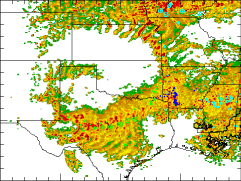
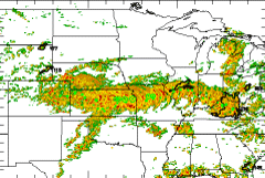
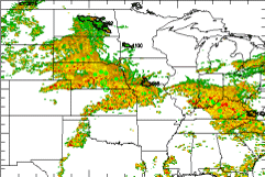
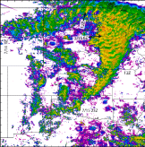
WSR-88D level II data were ordered from the National Climatic Data Center. Reflectivity and radial velocity fields on a spherical grid were interpolated to a regular latitude-longitude grid centered on the radar site. Elevation angle was preserved as the vertical coordinate. The grids encompassed four levels of spatial resolution and coverage:

0
0.005
60
1
0.01
120
2
0.02
240
3
0.04
459

Viewing tips

These AVI movies were created on an SGI workstation with dmconvert using QuickTime-Cinepak compression. They range in size from 0.5 to 4 Mb.