WRF Overview
The WRF model is a flexible, state-of-the-art atmospheric simulation system that is portable and efficient on parallel computing platforms. It is suitable for use across scales, ranging from meters to thousands of kilometers, for a broad range of applications, including the following.
Research Applications |
Functional Applications |
|---|---|
Parameterization |
Idealized simulations |
Data assimilation |
Real-time numerical weather prediction |
Forecasting |
Model coupling |
Tropical cyclones |
Teaching |
Regional climate |
|
Fire |
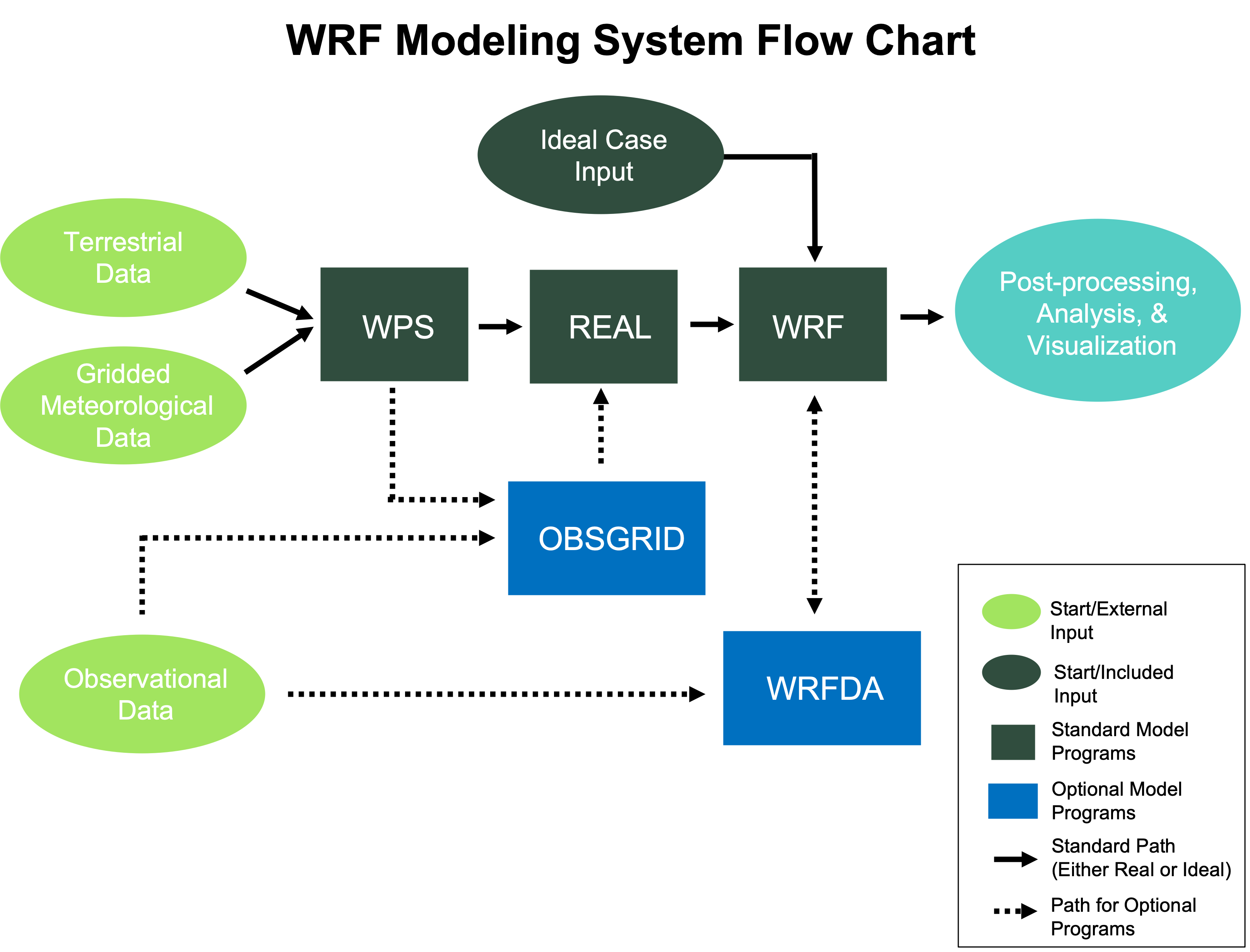
The WRF Modeling System consists of the following programs.
WRF Initialization Programs (Real and Ideal)
WRF-ARW Solver (WRF)
WRF Data Assimilation (WRFDA) (WRFDA)
WRF Preprocessing System (WPS)
The WPS is used for real-data simulations and functions to:
define simulation domains
interpolate terrestrial data (e.g., terrain, landuse, and soil types) to the simulation domain
degrib and horizontally interpolate meteorological input data from an outside model to the simulation domain
WRF Initialization
The WRF model is capable of simulating both real-data and idealized cases.
Real-data Cases
Real-data Case
A model simulation that uses real static geographical data (e.g., landuse) from reputable surveying projects, along with a previously-run external atmospheric analysis or forecast model (e.g., GFS) to provide initial and boundary conditions for the WRF simulation
The WRF Preprocessing System (WPS) processes the input atmospheric and static fields and interpolates them to a user-defined domain. WPS output files are used as input to the WRF’s real.exe initialization program.
Idealized Cases
Idealized Case
A model simulation of an “idealized,” simplified, and controlled environment
Idealized simulations are initiated from an an existing sounding (included with the code), and assume a simplified orography. Idealized simulations can provide the following:
Basic testing of the dynamics solver for a broad range of space and time scales
Reproducing known solutions
A starting point/template for other idealized experiments
Testing physics development
See WRF Initialization for details about available cases.
WRF-ARW Solver
The wrf.exe program is the primary component of the modeling system.
Key Features
Fully-compressible nonhydrostatic equations with a hydrostatic option
Complete Coriolis and curvature terms
Mass-based hybrid sigma-pressure vertical coordinate
Map-scale factors for these projections:
Polar Stereographic (conformal)
Lambert-conformal
Mercator (conformal)
Latitude and longitude, which can be rotated
Arakawa C-grid staggering
Scalar-conserving flux form for prognostic variables
Upper boundary absorption and Rayleigh damping
Lateral boundary conditions
Idealized cases: periodic, symmetric, and open radiative
Real cases: specified with relaxation zone
Full physics options for land-surface, planetary boundary layer, atmospheric and surface radiation, microphysics and cumulus convection
Orographic gravity wave drag
Additional Options
Regional and global applications
Two-way nesting with multiple nests and nest levels
Concurrent one-way nesting with multiple nests and nest levels
Offline one-way nesting with vertical nesting
Moving nests (prescribed moves and vortex tracking)
Vertical grid-spacing can vary with height
Runge-Kutta 2nd and 3rd order time integration options
2nd to 6th order advection options (horizontal and vertical)
Monotonic transport and positive-definite advection option for moisture, scalar, tracer, and TKE
Weighted Essentially Non-Oscillatory (WENO) advection option
Time-split small step for acoustic and gravity-wave modes:
Small step horizontally explicit, vertically implicit
Divergence damping option and vertical time off-centering
External-mode filtering option
Ocean models
Grid analysis nudging using separate upper-air and surface data, and observation nudging
Spectral nudging
Digital filter initialization
Adaptive time stepping
Stochastic parameterization schemes
A number of idealized examples
WRF Data Assimilation (WRFDA)
Important
WRFDA Notice, 20230901: NSF-NCAR/MMM no longer has a dedicated staff for supporting and developing WRFDA. While WRFDA will continue to be maintained, NSF-NCAR/MMM has primarily transitioned to the development of an MPAS data assimilation system based upon the Joint Effort for Data Assimilation Integration (JEDI), i.e., MPAS-JEDI. NSF-NCAR/MMM is working to develop the supporting materials and platform for MPAS-JEDI and offers MPAS-JEDI tutorials.
WRF Data Assimilation (WRFDA) is an optional program used to ingest observations into interpolated analysis created by WPS. It may also be used to update the WRF model’s initial conditions by running in “cycling” mode. WRFDA’s primary features are:
The capability of 3D and 4D hybrid data assimilation (Variational + Ensemble)
Based on an incremental variational data assimilation technique
Tangent linear and adjoint of WRF are fully integrated with WRF for 4D-Var
Utilizes the conjugate gradient method to minimize cost function in the analysis control variable space
Analysis on an un-staggered Arakawa A-grid
Analysis increments interpolated to staggered Arakawa C-grid, which is then added to the background (first guess) to get the final analysis of the WRF-model grid
Conventional observation data input may be supplied in either ASCII format via the obsproc utility, or PREPBUFR format
Multiple-satellite observation data input may be supplied in BUFR format
Two fast radiative transfer models, CRTM and RTTOV, are interfaced to WRFDA to serve as satellite radiance observation operator
Variational bias correction for satellite radiance data assimilation
All-sky radiance data assimilation capability
Multiple radar data (reflectivity & radial velocity) input is supplied through ASCII format
Multiple outer loop to address nonlinearity
Capability to compute adjoint sensitivity
Horizontal background (first guess) error is represented via a recursive filter (for regional) or power spectrum (for global)
Vertical background error is applied through projections on climatologically-generated, averaged eigenvectors and its corresponding Eigen values
Horizontal and vertical background errors are non-separable. Each eigenvector has its own horizontal climatologically-determined length scale
Preconditioning of the background of the cost function is done via the control variable transform U defined as B=UUT
gen_be utility to generate climatological background error covariance estimate via the NMC-method or ensemble perturbations
Utility program to update WRF boundary condition file after WRF-DA
Post-processing, Analysis, and Visualization Tools
The following post-processing programs are supported for use with WRF output.
- wrf-python
A collection of diagnostic and interpolation routines for use with output from the WRF model
- NCL (NCAR Command Language)
A free, interpreted language designed specifically for scientific data processing and visualization. NCL has robust file input and output. It can read in netCDF, HDF4, HDF4-EOS, GRIB, binary and ASCII data. The graphics are world-class and highly customizable.
- RIP (Read/Interpolate/Plot)
A Fortran program that invokes NCAR Graphics routines for the purpose of visualizing output from gridded meteorological data sets, primarily from mesoscale numerical models
- ARWpost
A package that reads-in WRF-ARW model data and creates GrADS output files.
- UPP (Unified Post Processing)
A system deleveloped at the National Centers for Environmental Prediction (NCEP) and is used operationally for models maintained by NCEP. It is currently supported by the Research Applications Laboratory (RAL) at NSF NCAR.
- VAPOR (Visualization and Analysis Platform for Ocean, Atmosphere, and Solar Researchers)
A 3-dimensional data visualization tool developed and supported by the VAPOR team at NSF NCAR (vapor at ucar dot edu)
- METplus (Model Evaluation Tools)
A verification system developed and supported by the Developmental Testbed Center at NSF NCAR (met_help at ucar dot edu).
Details of these programs (with the exception of METplus) are included in WRF Post-processing and , WRF Utilities and Tools.