The Basics for Running WPS and WRF
The following shows the full model program flow for a real-data WRF model simualation.
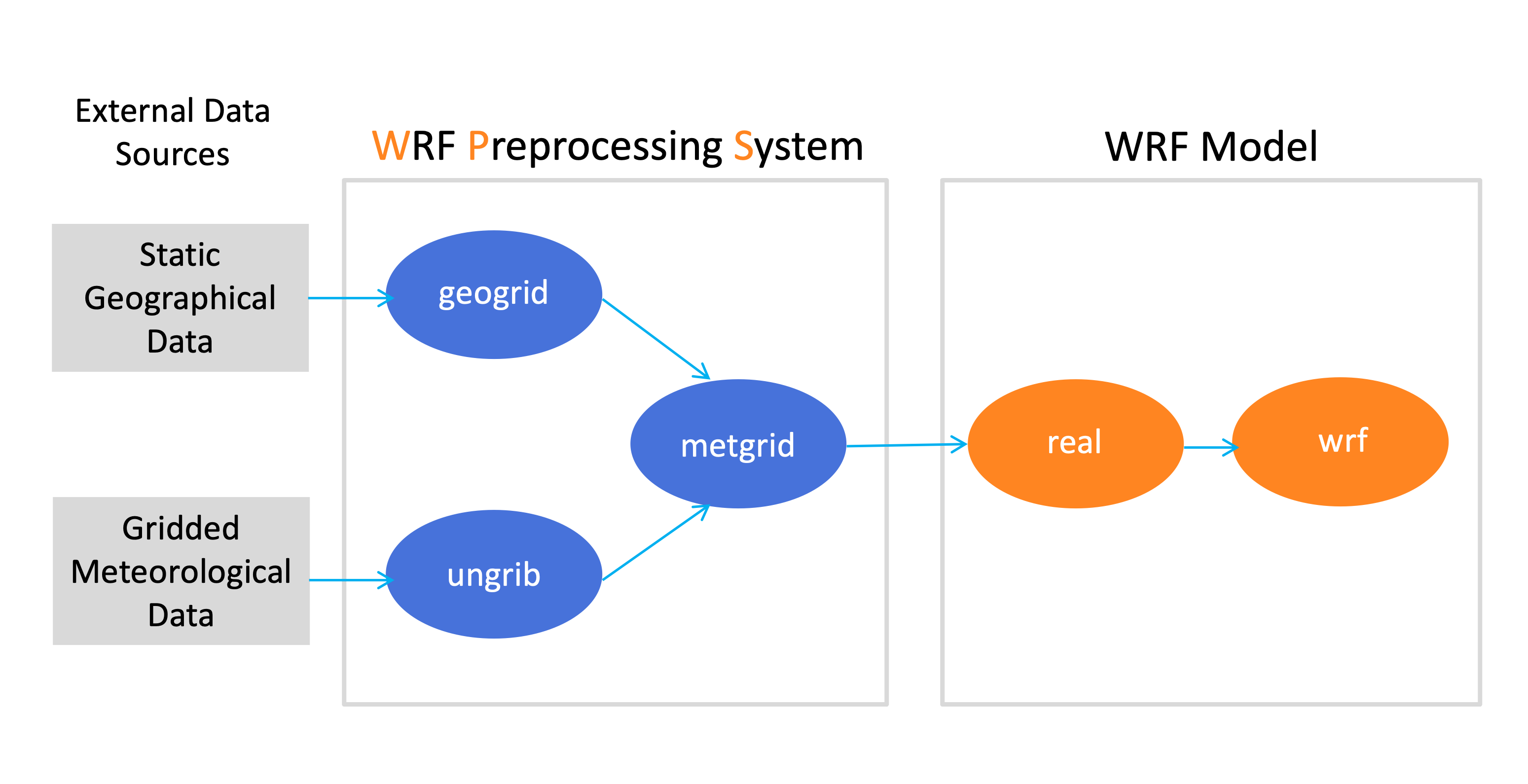
External Data Sources
Static Geographical Data : Earth’s geographical fields for topography, albedo, landuse, etc. These files are mandatory for running the WPS geogrid program. Obtain these files from Geographic Static Data for the WPS.
Gridded Meteorological Data : Meteorological 3d and surface GRIB-formatted data to be used as input to WRF. This is necessary for the ungrib program. See some options for obtaining input meteorological data.
WPS
The following three executables are used for WRF preprocessing. Details about each program are below.
geogrid.exe : program that defines the model domain and creates terrestrial data from static geographic data
ungrib.exe : program that unpacks GRIB-formatted meteorological data and packs it into the intermediate file format expected by the metgrid program
metgrid.exe : interpolates the meteorological data horizontally onto the model domain. Output from metgrid.exe is used as input to WRF (through the real.exe program)
Note
Within each section below are steps to follow when running each process. These are an abridged version for the purpose of explaining the process. There is no need to follow the steps yet. Full case study exercises are provided later.
Geogrid
The purpose of the geogrid program is to define the simulation domain(s), and interpolate various terrestrial data sets to the model grids.
Simulation domain(s) are defined using information specified by the user in the &share and &geogrid records in the WPS namelist (namelist.wps - available in the top-level WPS directory).
In addition to computing latitude and longitude for every grid point, geogrid interpolates soil categories, land use category, terrain height, deep-soil temperature, vegetation fraction, albedo, snow albedo, slope category, and more to the model grids.
Basic Steps to Run Geogrid
After step 1 below, move into the WPS directory for the remaining steps.
Download the geographic static fields and place them in a unique location.
Edit the &share and &geogrid namelist.wps records for the particular domain set-up.
Run geogrid.exe
Geogrid output files are in the format of geo_em.dxx.nc, where xx indicates the domain number. There will be one file available per domain. The file geogrid.log provides the logged information about the geogrid run.
Tip
Use the plotgrids_new.ncl script to ensure the domain is set up properly. This program requires an installation of NCL, as well as x-forwarding for a pop-up window on the screen. From the WPS/ directory, issue ncl util/plotgrids_new.ncl.
Ungrib
The purpose of the ungrib program is to unpack Grib-formatted (GRIB1 and GRIB2) meteorological data and convert it into an intermediate file format that is expected by the metgrid program.
Unpacking the data is controlled via the &share and &ungrib namelist.wps records. The ungrib program * is not dependent on the model domain(s). * is not dependent on the geogrid program. * does not cut down the data according to model domain specifications - it simply unpacks the required fields and writes them out into a format that the metgrid program can read. * makes use of Vtables (see sample Vtables in the WPS/ungrib/Variable_Tables/ directory) to specify which fields to unpack from the GRIB files. Vtables list the fields and their GRIB codes that must be unpacked from the GRIB files.
Note
If input data files are in a format other than GRIB, the data must be converted to the intermediate format and the ungrib program will not be used. See Writing Meteorological Data to the Intermediate Format. Additionally, try searching scripting options available from previous posts to the WRF & MPAS-A User Support Forum. After creating intermediate files manually, it is recommended to check the files with the WPS/util/rd_intermediate.exe utility.
Basic Steps to Run Ungrib
After step 1 below, move into the WPS directory for the remaining steps.
Download meteorological input data and place it in a unique directory (to keep organized). Note that input files are needed for the entire planned simulation time.
Link the correct Vtable from the ungrib/Variable_Tables directory, to the WPS directory, with the generic name “Vtable,” which is the file name expected by the ungrib program. For e.g., if using GFS data, use the following command:
ln -sf ungrib/Variable_Tables/Vtable.GFS Vtable
Use the link_grib.csh script (available in the top-level WPS directory) to link the Grib-formatted data to the WPS directory.
./link_grib.csh path-to-data-files/data-file-prefix
Note there is no need to provide a “.” at the end of the command, as this is built into the script. Only a data file prefix is needed. Make sure to link the specific files in, and not just the directory that holds them.
Edit the &share and &ungrib namelist.wps records - specifically start_date and end_date, interval_seconds, and prefix. Note that it is optional to modify the value of “FILE” for “prefix.” It may help if wanting to prevent saved files from being overwritten.
Run ungrib.exe
Ungrib output files are in the format of FILE:YYYY-MM-DD_hh - one for each time.
Note
Although Vtables are provided for many common data sets, it is not impossible for ungrib to anticipate every possible source of meteorological data in GRIB format. When a new source of data is to be processed by ungrib, the user may create a new Vtable, either from scratch, or by using an existing Vtable as a template. Basic knowledge of the meaning and use of the various fields in the Vtable will be helpful. Ensure the Vtable includes all required input for running WRF
Metgrid
The purpose of metgrid is to horizontally interpolate the meteorological data onto the model domain. Output from metgrid.exe is used as input to WRF.
The simulation domain(s) are defined using information specified by the user in the &share and &metgrid namelist records in namelist.wps.
Basic Steps to Run Metgrid
Input to the metgrid program are both the geo_em.dxx.nc, and the FILE:YYYY-MM-DD_hh files from the geogrid and ungrib programs. Make sure to be in the WPS directory for the following steps.
Edit the &share and &metgrid namelist.wps records.
Run metgrid.exe
Output files from the metgrid program are in the format met_em.dxx.YYYY-MM-DD_hh:00:00.nc - one file per time, per domain (dxx represents the domain number).
See also
See namelist.wps Best Practices for details and recommendations for WPS namelist parameter settings.
WRF
The following two executables are used in the WRF process.
real.exe : program that vertically interpolates the data onto the model coordinates
wrf.exe : program that generates the model forecast and output
All user settings can be applied to namelist.input (available in the WRF/test/em_real directory).
Real
Basic Steps to Run Real
Move into the WRF/test/em_real directory.
Link in the met_em files from WPS, as these are the input used for the real program.
ln -sf path-to-wps-directory/met_em* .
Edit namelist.input for the specific domain set-up, timing information, and additional options. See namelist.input Best Practices for details and recommendations for namelist parameter settings.
Run real.exe.
If this runs successfully, the output should be a wrfinput_d0x files - one for each domain, and a wrfbdy_d01 file - only for domain 01.
WRF
Basic Steps to Run WRF
Run wrf.exe.
If this is succesful, the output files should be in the format wrfout_d0x_YYYY-MM-DD_hh:mm:ss for each time and each domain.
See also
Find detailed information on the above programs in the WRF Users’ Guide.